Maps of South West England

De Bocht van Vranckryck oock 't Canaal aen te doen, comende uyten Westen [Karte], in: De Nieuwe Groote Vermeerderde Zee-Atlas ofte Water-Werelt, S. 47.
1 Karte aus Atlas Doncker, Hendrick
Le Ponant
1 Karte auf 2 Blättern : Kupferdruck ; 80 x 81 cm Dicquemare; Patry; Nicollet chez. J. B. Patry M.d libraire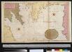
Afteekening van de Bogt van Vrankrijk, een gedeelte van het Canaal als ook t Verkeerde Canaal met de Zuijt cust van Irlandt
Bay of Biscay Gerard van Keulen
A large chart of the BAY OF BISCAY
from The sea-atlas : containing an hydrographical description of most of the sea-coasts of the known parts of the world.
Pas caert van 't in komen van de Canael
1 Karte : Kupferdruck ; 42 x 53 cm Doncker bÿ Hendrick Doncker boeckverkoper inde Nieuwbrugh steegh in 't Stuurmans gereetschap
[131][134] Galliae, Biscajae et Gallissiae Sinus ... De Bocht van Vranckryck ..., uit: Atlas sive Descriptio terrarum orbis
Annotatie: Gedigitaliseerde versie. Amsterdam. Heiloo : Picturae (vervaardiger), 2015. tiff-bestand. Gedigitaliseerd: 07-01-2015; Origineel: Universiteitsbibliotheek Vrije Universiteit (XL.05127.-) ; Netherlands; Titelpagina ontbreekt Wit, Frederik de Amsterdam : Frederick de Wit
Galliæ, Biscajæ et Gallissiæ sinus
1 Karte : Kupferdruck ; 48 x 55 cm Renard gedruckt bÿ L. Renard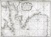
Carte de la Manche des costes de France
1 Karte : Kupferdruck ; 52 x 72 cm Huc; Ch chez le Sr. Huc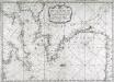
Carte de la Manche des costes de France
1 Karte : Kupferdruck ; 52 x 72 cm Huc; Ch chez le Sr. Huc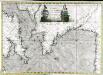
Carte de la Manche des costes de France
1 Karte auf 2 Blättern : Kupferdruck ; 51 x 72 cm Probst; Jäck; Ch chez Iean Michel Probst
Brittische Übermacht zur See wider Franckreich a.o 1759, in denen Unternehmungen derer Engelländer auf die französisch Küsten, nach denen besten Engl. u. Französischen Original Berichten und durch kostbahre Correspondence erhaltene Gewissheit
1 : 2500000 gezeichnet u. historisch erklähret durch Christian Fried. von der Heyden designée fort exactement et explicque par Chrétien Frédéric de Heyden ; gravé par M. A. Lotter, le fis in Augsp : verlegt von Tob. Conr. Lotter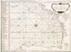
Accurate chart of the Bay of Biscay
Neptune Occidental. A Compleat Pilot for the West-Indies, including the British Channel, Bay of Biscay, and all the Atlantic islands; with their bays, harbours, keys, rocks, land-marks, depths of water, latitudes, longitudes &c. &c. ... Done from actual surveys, by the late Thomas Jefferys ... on twenty-eight large imperial plates. Jefferys, Thomas. London : Printed for R. Sayer and J. Bennett
Pas-caert van de bocht van Vranckrijck, Biscajen en Galissen; tusschen Heyssant en C. de Finisterre
1 Karte : Kupferdruck ; 42 x 53 cm Doncker bÿ Hendrick Doncker inde Nieuwbrug steegh in 't Stuurmans gereetschap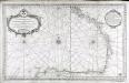
Carte reduite du golphe de Gascogne
1 Karte : Kupferdruck ; 53 x 84 cm Bellin s.n.
Partie, l'Espagne. Europe 18.
1 : 1641836 Vandermaelen, Philippe, 1795-1869
Brittische Übermacht zur See wider Franckreich a.o 1759
1 Karte : Kupferdruck ; 46 x 36 cm, Bildgrösse 48 x 47 cm Heyden; Lotter; Lotter verlegt von Tob: Conr: Lotter
Carte des iles britanniques ou Royaume-Uni de la Grande Bretagne et d'Irlande, 5
2 Blätter : je 50 x 39 cm
Atlantischer Ozean
1 : 600000 Atlantský oceán Admiralität
[Frankreich in 4 Blättern, Nordwestliches Frankreich]
Hand-Atlas über alle Theile der Erde und über das Weltgebäude Stieler, Adolf Justus Perthes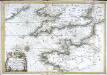
Carte de la Manche
1 Karte : Kupferdruck ; 47 x 68 cm Denis; Basset; Basset chés Basset rue St. Jacques au coin de celle des Mathurins
France, Belgium & Holland - political.
1 : 3000000 John Bartholomew and Son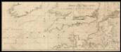
To the right honorable the Masters, Wardens and Eldeil Brother of the Trinity House, this chart of the English Channel: Downs and Margaret; Plysmouth; Falmouth; Portsmouth; Dartmouth
7 Carta nàutica. - Conté carta nàutica de: Dartmouth; Downs and Margate; Plymouth; Falmouth; The Owers Light; Portsmouth Heather, William W. Heather
Galliæ antiquæ descriptio geographica, 3
1 Blatt : 42 x 57 cm s.n.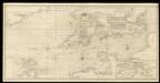
An exact trigonometrical survey of the British Channel, including the mouth of the Thames and Part of the German sea with the coast of Irland from Carnsore point to the Shannon Mouth
Laurie & Whittle
France.
1 : 4400000 Vivien de St Martin, L.
Cartes des terrains d ́atterrissage de France
Northwestern France
1 : 2350000 Relief shown by shading. "Base map No. 2995 (free)." "January 14, 1944." Oriented with north to the bottom. United States. Office of Strategic Services. Research and Analysis Branch [Washington, D.C.] : R & A, OSS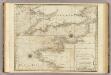
A chart of the British Channel.
1 : 1780000 Jefferys, Thomas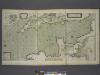
A new and correct draught of the CHANNELL between ENGLAND and FRANCE
from The sea-atlas : containing an hydrographical description of most of the sea-coasts of the known parts of the world.
![De Bocht van Vranckryck oock 't Canaal aen te doen, comende uyten Westen [Karte], in: De Nieuwe Groote Vermeerderde Zee-Atlas ofte Water-Werelt, S. 47.](https://images-2.georeferencer.com/images/iiif/364948935098/full/,300/0/native.jpg)

