Maps of Normandy

France.
1 : 4400000 Vivien de St Martin, L.

La Manche, ou le Canal, entre la France et l'Angleterre
1 Karte : Kupferdruck ; 49 x 59 cm Jaillot; Goere H. Jaillot
France N.O.
1 : 1615000 Migeon, J.
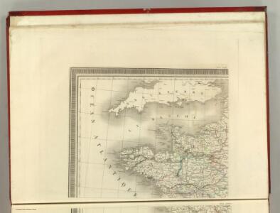
Le royaume de la France occidentale dit autrement Neustrie
1 Karte : Kupferdruck ; 39 x 49 cm, Bildgrösse 41 x 56 cm Duval chez l'auteur en l'isle du Palais sur le quay de l'Orloge
[Frankreich in 4 Blättern, Nordwestliches Frankreich]
Hand-Atlas über alle Theile der Erde und über das Weltgebäude Stieler, Adolf Justus Perthes
A chart of the British Channel.
1 : 1780000 Jefferys, Thomas
Carte de la République française, 1
1 Blatt : 42 x 51 cm P.G. Chanlaire
Manica, gallis la Manche, et belgis het Canaal, pars oceani inter Angliam et Gallicam
1 Karte : Kupferdruck ; 46 x 55 cm Visscher; Gouwen Nicolaes Visscher
La Manche
1 Karte : Kupferdruck ; 50 x 61 cm Jefferys; Le Rouge chez Le Rouge géographe du roi rue des g.ds Augustins
Carte de la France, 1
2 Blätter : mehrfarbig ; 72 x 81 cm de Belleyme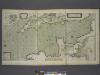
A new and correct draught of the CHANNELL between ENGLAND and FRANCE
from The sea-atlas : containing an hydrographical description of most of the sea-coasts of the known parts of the world.
Carte de la Manche
1 Karte : Kupferdruck ; 50 x 66 cm Lattré chéz Lattré graveur ordinaire du roi de M. le duc d'Orléans et de la ville rue St. Jacques la porte cochère en face de la rue de la Parcheminerie
Pas caart van de canaal tusschen Engeland en Vrancrijck
1 Karte : Kupferdruck ; 43 x 53 cm Doncker by Hendrick Doncker boeckverkoper en graedbooghmaecker inde Nieuwbrugsteegh in 't Stuurmans gereedschap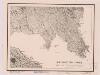
Northwestern France
1 : 2350000 Relief shown by shading. "Base map No. 2995 (free)." "January 14, 1944." Oriented with north to the bottom. United States. Office of Strategic Services. Research and Analysis Branch [Washington, D.C.] : R & A, OSS
La Manche
1 Karte : Kupferdruck ; 50 x 61 cm Jefferys; Le Rouge chez Le Rouge géographe du roi rue des g.ds Augustins
France I.
1 : 1800000 Society for the Diffusion of Useful Knowledge (Great Britain)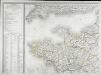
Carte de la France, 1
1 Blatt : 61 x 83 cm de Belleyme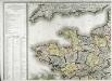
Carte de la France, 1
1 Blatt : 61 x 82 cm de Belleyme
Frankreich NW.
1 : 1700000 Handtke, Friedrich H.
Frankreich In 4 Blattern, Blatt 1.
1 : 1500000 Vogel, C.
Canalis inter Angliæ et Galliæ littora
1 Karte : Kupferdruck ; 48 x 55 cm Renard gedruckt by L. Renard
[Frankreich in 4 Blättern, Blatt 1]
Handatlas über alle Theile der Erde und über das Weltgebäude Stieler, Adolf Justus Perthes
Der Nord-Westliche Theil von Frankreich
Hand-Atlas über alle Theile der Erde nach dem neuesten Zustande und über das Weltgebäude Stieler, Adolf bei Justus Perthes
[Frankreich, Blatt 1]
Adolf Stieler's Handatlas über alle Theile der Erde und über das Weltgebäude Stieler, Adolf Justus Perthes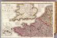
France 1.
1 : 1170000 Herisson, Eustache, b. 1759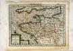
Breta[n]nia et Normandia cum confinijs
1 Karte : Kupferdruck ; 17 x 24 cm Mercator Cloppenburgh
A Chart of the English Channel with the adjacent coasts of England and France.
from Atlantic Ocean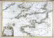
Carte de la Manche
1 Karte : Kupferdruck ; 47 x 68 cm Denis; Basset; Basset chés Basset rue St. Jacques au coin de celle des Mathurins