Maps of New Aquitaine

A large chart of the BAY OF BISCAY
from The sea-atlas : containing an hydrographical description of most of the sea-coasts of the known parts of the world.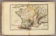
France physique.
1 : 4400000 Vincent
Le Ponant
1 Karte auf 2 Blättern : Kupferdruck ; 80 x 81 cm Dicquemare; Patry; Nicollet chez. J. B. Patry M.d libraire
[131][134] Galliae, Biscajae et Gallissiae Sinus ... De Bocht van Vranckryck ..., uit: Atlas sive Descriptio terrarum orbis
Annotatie: Gedigitaliseerde versie. Amsterdam. Heiloo : Picturae (vervaardiger), 2015. tiff-bestand. Gedigitaliseerd: 07-01-2015; Origineel: Universiteitsbibliotheek Vrije Universiteit (XL.05127.-) ; Netherlands; Titelpagina ontbreekt Wit, Frederik de Amsterdam : Frederick de Wit
United Kingdoms.
1 : 4500000 Arrowsmith, Aaron
United Kingdoms.
1 : 4500000 Arrowsmith, Aaron
Galliæ, Biscajæ et Gallissiæ sinus
1 Karte : Kupferdruck ; 48 x 55 cm Renard gedruckt bÿ L. Renard
De Bocht van Vranckryck oock 't Canaal aen te doen, comende uyten Westen [Karte], in: De Nieuwe Groote Vermeerderde Zee-Atlas ofte Water-Werelt, S. 47.
1 Karte aus Atlas Doncker, Hendrick
Pas-caert van de bocht van Vranckrijck, Biscajen en Galissen; tusschen Heyssant en C. de Finisterre
1 Karte : Kupferdruck ; 42 x 53 cm Doncker bÿ Hendrick Doncker inde Nieuwbrug steegh in 't Stuurmans gereetschap
Carte de la Manche des costes de France
1 Karte : Kupferdruck ; 52 x 72 cm Huc; Ch chez le Sr. Huc
Brittische Übermacht zur See wider Franckreich a.o 1759, in denen Unternehmungen derer Engelländer auf die französisch Küsten, nach denen besten Engl. u. Französischen Original Berichten und durch kostbahre Correspondence erhaltene Gewissheit
1 : 2500000 gezeichnet u. historisch erklähret durch Christian Fried. von der Heyden designée fort exactement et explicque par Chrétien Frédéric de Heyden ; gravé par M. A. Lotter, le fis in Augsp : verlegt von Tob. Conr. Lotter
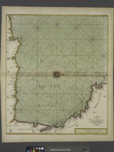
Accurate chart of the Bay of Biscay
Neptune Occidental. A Compleat Pilot for the West-Indies, including the British Channel, Bay of Biscay, and all the Atlantic islands; with their bays, harbours, keys, rocks, land-marks, depths of water, latitudes, longitudes &c. &c. ... Done from actual surveys, by the late Thomas Jefferys ... on twenty-eight large imperial plates. Jefferys, Thomas. London : Printed for R. Sayer and J. Bennett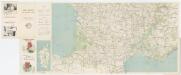
Carte Michelin 99: France - Sud, uit: Carte Michelin au 1:1.000.000e (1 cm = 10 km) : les grandes routes de France
1 : 1000000 Clermont-Ferrand : Michelin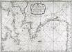
Carte de la Manche des costes de France
1 Karte : Kupferdruck ; 52 x 72 cm Huc; Ch chez le Sr. Huc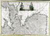
Carte de la Manche des costes de France
1 Karte auf 2 Blättern : Kupferdruck ; 51 x 72 cm Probst; Jäck; Ch chez Iean Michel Probst
France provinces.
1 : 5000000 Bowen, Frances
France departments.
1 : 5000000 Bowen, Frances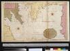
Afteekening van de Bogt van Vrankrijk, een gedeelte van het Canaal als ook t Verkeerde Canaal met de Zuijt cust van Irlandt
Bay of Biscay Gerard van Keulen
Cartes des terrains d ́atterrissage de France

Brittische Übermacht zur See wider Franckreich a.o 1759
1 Karte : Kupferdruck ; 46 x 36 cm, Bildgrösse 48 x 47 cm Heyden; Lotter; Lotter verlegt von Tob: Conr: Lotter
Partie, l'Espagne. Europe 18.
1 : 1641836 Vandermaelen, Philippe, 1795-1869
Galliæ antiquæ descriptio geographica, 3
1 Blatt : 42 x 57 cm s.n.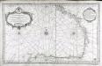
Carte reduite du golphe de Gascogne
1 Karte : Kupferdruck ; 53 x 84 cm Bellin s.n.
Le royaume d'Aquitaine
1 Karte : Kupferdruck ; 40 x 49 cm, Bildgrösse 41 x 56 cm Duval chez l'auteur en l'isle du Palais sur le quay de l'Orloge au coin de la rüe de Harlay
Atlantischer Ozean
1 : 600000 Atlantský oceán Admiralität
Carte de la France, 3
1 Blatt : 61 x 83 cm de Belleyme
Carte de la France, 3
1 Blatt : mehrfarbig ; 61 x 83 cm de Belleyme
Carte de la France, 3
1 Blatt : 61 x 82 cm de Belleyme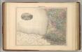
France S.O.
1 : 1615000 Migeon, J.