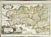
Maps of Bretagne
Carte reduite du golphe de Gascogne
1 Karte : Kupferdruck ; 53 x 84 cm Bellin s.n.
Accurate chart of the Bay of Biscay
Neptune Occidental. A Compleat Pilot for the West-Indies, including the British Channel, Bay of Biscay, and all the Atlantic islands; with their bays, harbours, keys, rocks, land-marks, depths of water, latitudes, longitudes &c. &c. ... Done from actual surveys, by the late Thomas Jefferys ... on twenty-eight large imperial plates. Jefferys, Thomas. London : Printed for R. Sayer and J. Bennett
Pas-caert van de bocht van Vranckrijck, Biscajen en Galissen; tusschen Heyssant en C. de Finisterre
1 Karte : Kupferdruck ; 42 x 53 cm Doncker bÿ Hendrick Doncker inde Nieuwbrug steegh in 't Stuurmans gereetschap
Galliæ antiquæ descriptio geographica, 3
1 Blatt : 42 x 57 cm s.n.
Atlantischer Ozean
1 : 600000 Atlantský oceán Admiralität
Le royaume d'Aquitaine
1 Karte : Kupferdruck ; 40 x 49 cm, Bildgrösse 41 x 56 cm Duval chez l'auteur en l'isle du Palais sur le quay de l'Orloge au coin de la rüe de Harlay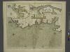
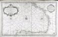
The sea coast of FRANCE from Ushent to Olone
from The sea-atlas : containing an hydrographical description of most of the sea-coasts of the known parts of the world.
France Flle. Ouest.
1 : 1000000 Vivien St Martin, L.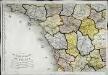
Carte de la république de France, no. 3
1 Blatt : 41 x 59 cm s.n.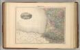
France S.O.
1 : 1615000 Migeon, J.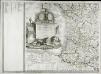
Carte de la France, 3
1 Blatt : 61 x 83 cm de Belleyme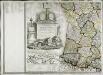
Carte de la France, 3
1 Blatt : mehrfarbig ; 61 x 83 cm de Belleyme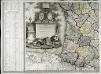
Carte de la France, 3
1 Blatt : 61 x 82 cm de Belleyme
Carte de France, 5
2 Blätter : Kupferdruck ; 53 x 44 cm Crepy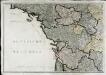
Neueste Generalkarte von Frankreich, 3
1 Blatt : 55 x 78 cm F.A. Schrämbl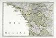
Troisieme feuille contenant une partie de la Bretagne, l'Anjou, la Touraine, le Poitou, la Saintonge, la Marche et le Limosin
1 Blatt : 34 x 55 cm Bourgoin
Karte von Frankreich in XVI Blättern, No. 9 und [No. 13]
2 Blätter : 52 x 33 cm Königl. Preuss. Academischen Kunst und Buchhandlung
Carte de la France (SO)
1 : 345600 Cassini family
Schauplaz des Krieges der Vendeer und Chouans
1 Karte : Kupferdruck ; 36 x 40 cm Abel s.n.
Duche de Bretaigne [Karte], in: Novus atlas absolutissimus, Bd. 4, S. 138.
1 Karte aus Atlas Janssonius Offizin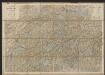
Duche de Bretaigne [Karte], in: Gerardi Mercatoris et I. Hondii Newer Atlas, oder, Grosses Weltbuch, Bd. 2, S. 74.
1 Karte aus Atlas Mercator, Gerhard und Hondius, Jodocus Jansson, Jan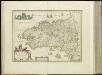
[15][15] Duche de Bretaigne, uit: Atlas sive Descriptio terrarum orbis
Annotatie: Gedigitaliseerde versie. Amsterdam. Heiloo : Picturae (vervaardiger), 2015. tiff-bestand. Gedigitaliseerd: 07-01-2015; Origineel: Universiteitsbibliotheek Vrije Universiteit (XL.05127.-) ; Netherlands; Titelpagina ontbreekt Wit, Frederik de Amsterdam : Frederick de Wit
Tabula ducatus Brittaniae Gallis
1 : 511000 Bretaň (Francie) Homann, Johann Baptist Ioh. Bapt. Homanno
Composite 8: Carte de France.
1 : 86400 Cassini family; Cassini, Cesar-Francois, 1714-1784
Bovrdelois, pays de Medoc, et la prevoste de Born
1 Karte : Kupferdruck ; 36 x 48 cm Hondius; Hamersvelt; Mercator excudit Judocus Hondius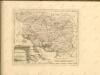

Carte de la France, no. 22
1 Blatt : 60 x 41 cm s.n.
Bovrdelois, pays de Medoc, et la prevost de Born
1 : 600000 Bordeaux (Francie) Hamersveldt, Everard S. van P. Schenk et G. Valk
Duché et gouvernement de Bretagne
1 Karte : Kupferdruck ; 25 x 34 cm Merian Caspar Merian