Maps of France
Carte de la Manche des costes de France
1 Karte : Kupferdruck ; 52 x 72 cm Huc; Ch chez le Sr. Huc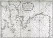
Carte de la Manche des costes de France
1 Karte : Kupferdruck ; 52 x 72 cm Huc; Ch chez le Sr. Huc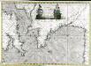
Carte de la Manche des costes de France
1 Karte auf 2 Blättern : Kupferdruck ; 51 x 72 cm Probst; Jäck; Ch chez Iean Michel Probst
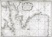
Brittische Übermacht zur See wider Franckreich a.o 1759, in denen Unternehmungen derer Engelländer auf die französisch Küsten, nach denen besten Engl. u. Französischen Original Berichten und durch kostbahre Correspondence erhaltene Gewissheit
1 : 2500000 gezeichnet u. historisch erklähret durch Christian Fried. von der Heyden designée fort exactement et explicque par Chrétien Frédéric de Heyden ; gravé par M. A. Lotter, le fis in Augsp : verlegt von Tob. Conr. Lotter
Le Ponant
1 Karte auf 2 Blättern : Kupferdruck ; 80 x 81 cm Dicquemare; Patry; Nicollet chez. J. B. Patry M.d libraire
Brittische Übermacht zur See wider Franckreich a.o 1759
1 Karte : Kupferdruck ; 46 x 36 cm, Bildgrösse 48 x 47 cm Heyden; Lotter; Lotter verlegt von Tob: Conr: Lotter
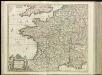
[13][13] Accuratissima Galliae tabula, uit: Atlas sive Descriptio terrarum orbis
Annotatie: Gedigitaliseerde versie. Amsterdam. Heiloo : Picturae (vervaardiger), 2015. tiff-bestand. Gedigitaliseerd: 07-01-2015; Origineel: Universiteitsbibliotheek Vrije Universiteit (XL.05127.-) ; Netherlands; Titelpagina ontbreekt Wit, Frederik de Amsterdam : Frederick de Wit
Homannův atlas světa
1 : 2350000

Die durch die Engellænder beunruhigte französische Küsten a.o 1758
1 Karte : Kupferdruck ; 47 x 49 cm, Bildgrösse 48 x 59 cm Heyden; Lotter; Lotter verlegt von Tobias Conrad Lotter
Die Reiche der Franken in Gallien unter den Merovingern.
1 : 3800000 Spruner von Merz, Karl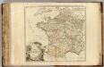
France postes.
1 : 2400000 Robert de Vaugondy, Gilles, 1688-1766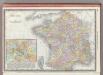
France.
1 : 3040000 Rand McNally and Company
France provinces.
1 : 5000000 Bowen, Frances
France departments.
1 : 5000000 Bowen, Frances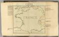
Confins (de la France)
1 : 2900000 Dangeau, abbe de, 1643-1723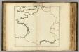
Confins (de la France - outline)
1 : 2900000 Dangeau, abbe de, 1643-1723
Cartes des terrains d ́atterrissage de France

Jak vzniká mapa

France.
1 : 5000000 Carey, Mathew
France.
1 : 4900000 Carey, Mathew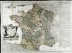
La France
1 Karte auf 2 Blättern : Kupferdruck ; 70 x 81 cm Janvier; Lattré; Arrivet chez Lattré graveur ruë St. Jacques près la fontaine S. Severin à la ville de Bordeaux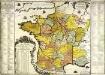
La France
1 Karte : Kupferdruck ; 48 x 49 cm Fer; Danet chez le Sr. Danet gendre de l'auteur sur le Pont N. Dame a la sphere royale
Frankreich von 1180 bis 1461, Zeitraum der Albigenser- und englischen Kriege.
1 : 3800000 Spruner von Merz, Karl
A large chart of the BAY OF BISCAY
from The sea-atlas : containing an hydrographical description of most of the sea-coasts of the known parts of the world.
[Frankreich in 4 Blättern, Nordwestliches Frankreich]
Hand-Atlas über alle Theile der Erde und über das Weltgebäude Stieler, Adolf Justus Perthes
La France divisée en provinces et en généralités, dont le plan est celui de l'ancienne Gaul
1 : 2500000
France.
1 : 3350000 Mitchell, Samuel Augustus
France.
1 : 3350000 Mitchell, Samuel Augustus


