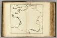
Maps of Metropolitan France

Die durch die Engellænder beunruhigte französische Küsten a.o 1758
1 Karte : Kupferdruck ; 47 x 49 cm, Bildgrösse 48 x 59 cm Heyden; Lotter; Lotter verlegt von Tobias Conrad Lotter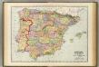
Spain, Portugal.
1 : 1930000 Rand McNally and Company
Spain, Portugal, W. France.
1 : 3000000 Philip, George
Brittische Übermacht zur See wider Franckreich a.o 1759, in denen Unternehmungen derer Engelländer auf die französisch Küsten, nach denen besten Engl. u. Französischen Original Berichten und durch kostbahre Correspondence erhaltene Gewissheit
1 : 2500000 gezeichnet u. historisch erklähret durch Christian Fried. von der Heyden designée fort exactement et explicque par Chrétien Frédéric de Heyden ; gravé par M. A. Lotter, le fis in Augsp : verlegt von Tob. Conr. Lotter
Jak vzniká mapa
Carte de la Manche des costes de France
1 Karte : Kupferdruck ; 52 x 72 cm Huc; Ch chez le Sr. Huc
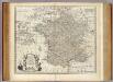
Carte de la Manche des costes de France
1 Karte auf 2 Blättern : Kupferdruck ; 51 x 72 cm Probst; Jäck; Ch chez Iean Michel Probst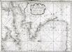
Carte de la Manche des costes de France
1 Karte : Kupferdruck ; 52 x 72 cm Huc; Ch chez le Sr. Huc
Jak vzniká mapa

Le Ponant
1 Karte auf 2 Blättern : Kupferdruck ; 80 x 81 cm Dicquemare; Patry; Nicollet chez. J. B. Patry M.d libraire
Landtaflen
1 Atlas [von Johannes Stumpf] Christoffel Froschower, Zürych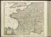
[13][13] Accuratissima Galliae tabula, uit: Atlas sive Descriptio terrarum orbis
Annotatie: Gedigitaliseerde versie. Amsterdam. Heiloo : Picturae (vervaardiger), 2015. tiff-bestand. Gedigitaliseerd: 07-01-2015; Origineel: Universiteitsbibliotheek Vrije Universiteit (XL.05127.-) ; Netherlands; Titelpagina ontbreekt Wit, Frederik de Amsterdam : Frederick de Wit
Totius regni Galliæ, sive Franciæ et Navarræ novissima tabula
1 Karte : Kupferdruck ; 47 x 55 cm Homann edita à Io. Bapt. Homann
Gallia [Karte], in: Gerardi Mercatoris Atlas, sive, Cosmographicae meditationes de fabrica mundi et fabricati figura, S. 213.
1 Karte aus Atlas Mercator, Gerhard Montanus, Petrus
Galliae supra omnes in hac forma editiones locupletißima et exatißima descriptio. [Karte], in: Gerardi Mercatoris et I. Hondii Newer Atlas, oder, Grosses Weltbuch, Bd. 2, S. 16.
1 Karte aus Atlas Mercator, Gerhard und Hondius, Jodocus Jansson, Jan

Jak vzniká mapa

Frankreich
Adolf Stieler's Handatlas über alle Theile der Erde und über das Weltgebäude Stieler, Adolf Justus Perthes
Jak vzniká mapa
Map of France.
1 : 3300000 Bowen, Emanuel
Jak vzniká mapa


GALLIA | LE | ROYAVME | DE | FRANCE.
I. vanden Ende fec. Amsterodami | Excudebat Guilielmus | Blaeuw Sub Signo Solarii
Frankreich nach der alten und neuen Eintheilung
1 Karte : Kupferdruck ; 28 x 24 cm Sotzmann; Jättnig s.n.
Sprachkarte von Frankreich.
1 : 3700000 Berghaus, Heinrich
Die Reiche der Franken in Gallien unter den Merovingern.
1 : 3800000 Spruner von Merz, Karl
Le royaume de France
1 : 2670000 Francie Seutter, Matthäus Matthieu Seutter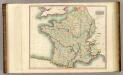
France.
1 : 2300000 Thomson, John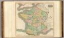
France, provinces.
1 : 2300000 Thomson, John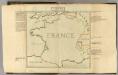
Confins (de la France)
1 : 2900000 Dangeau, abbe de, 1643-1723