Maps of Pays de la Loire

[Frankreich in 4 Blättern, Nordwestliches Frankreich]
Hand-Atlas über alle Theile der Erde und über das Weltgebäude Stieler, Adolf Justus Perthes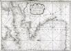
Carte de la Manche des costes de France
1 Karte : Kupferdruck ; 52 x 72 cm Huc; Ch chez le Sr. Huc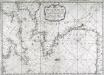
Carte de la Manche des costes de France
1 Karte : Kupferdruck ; 52 x 72 cm Huc; Ch chez le Sr. Huc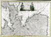
Carte de la Manche des costes de France
1 Karte auf 2 Blättern : Kupferdruck ; 51 x 72 cm Probst; Jäck; Ch chez Iean Michel Probst
Der Nord-Westliche Theil von Frankreich
Hand-Atlas über alle Theile der Erde nach dem neuesten Zustande und über das Weltgebäude Stieler, Adolf bei Justus Perthes

Northwestern France
1 : 2350000 Relief shown by shading. "Base map No. 2995 (free)." "January 14, 1944." Oriented with north to the bottom. United States. Office of Strategic Services. Research and Analysis Branch [Washington, D.C.] : R & A, OSS
Der Nord-Westliche Theil von Frankreich
Stieler's Hand-Atlas Stieler, Adolf bei Justus Perthes
France.
1 : 4400000 Vivien de St Martin, L.
Frankreich NW.
1 : 1700000 Handtke, Friedrich H.
France I.
1 : 1800000 Society for the Diffusion of Useful Knowledge (Great Britain)
Brittische Übermacht zur See wider Franckreich a.o 1759
1 Karte : Kupferdruck ; 46 x 36 cm, Bildgrösse 48 x 47 cm Heyden; Lotter; Lotter verlegt von Tob: Conr: Lotter
Der Nord-Westliche Theil von Frankreich
Hand-Atlas über alle Theile der Erde nach dem neuesten Zustande und über das Weltgebäude Stieler, Adolf bei Justus Perthes
La Manche, ou le Canal, entre la France et l'Angleterre
1 Karte : Kupferdruck ; 49 x 59 cm Jaillot; Goere H. Jaillot
France Régionale France de l’Ouest Normandie-Bretagne-Charentes carte physique
Gallois, Lucien
France Régionale France de l’Ouest Normandie-Bretagne-Charentes carte politique
Gallois, Lucien
France 1.
1 : 1774080 Letts, Son & Co.
Britannia & Normandia cum confinibus regionibus [Karte], in: Gerardi Mercatoris Atlas, sive, Cosmographicae meditationes de fabrica mundi et fabricati figura, S. 220.
1 Karte aus Atlas Mercator, Gerhard Montanus, Petrus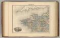
France N.O.
1 : 1615000 Migeon, J.
[Frankreich in 4 Blättern, Blatt 1]
Handatlas über alle Theile der Erde und über das Weltgebäude Stieler, Adolf Justus Perthes
[Frankreich, Blatt 1]
Adolf Stieler's Handatlas über alle Theile der Erde und über das Weltgebäude Stieler, Adolf Justus Perthes
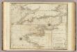
A chart of the British Channel.
1 : 1780000 Jefferys, Thomas
Frankreich In 4 Blattern, Blatt 1.
1 : 1500000 Vogel, C.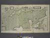
A new and correct draught of the CHANNELL between ENGLAND and FRANCE
from The sea-atlas : containing an hydrographical description of most of the sea-coasts of the known parts of the world.
Carte de la République française, 1
1 Blatt : 42 x 51 cm P.G. Chanlaire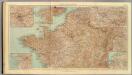
32-34. Francia nord.
1 : 1500000 Touring club italiano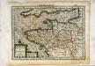
Breta[n]nia et Normandia cum confinijs
1 Karte : Kupferdruck ; 17 x 24 cm Mercator Cloppenburgh
![[Frankreich in 4 Blättern, Nordwestliches Frankreich]](https://images-2.georeferencer.com/images/iiif/857888332036/full/,300/0/native.jpg)

