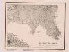
Maps of South West England
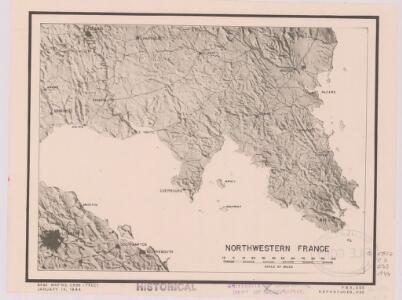
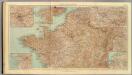
Northwestern France
1 : 2350000 Relief shown by shading. "Base map No. 2995 (free)." "January 14, 1944." Oriented with north to the bottom. United States. Office of Strategic Services. Research and Analysis Branch [Washington, D.C.] : R & A, OSS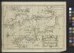
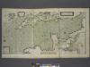
A Chart of the English Channel with the adjacent coasts of England and France.
from Atlantic Ocean
La Manche, ou le Canal, entre la France et l'Angleterre
1 Karte : Kupferdruck ; 49 x 59 cm Jaillot; Goere H. Jaillot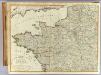
N.W. France.
1 : 1000000 Robert Laurie & James Whittle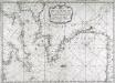
Carte de la Manche des costes de France
1 Karte : Kupferdruck ; 52 x 72 cm Huc; Ch chez le Sr. Huc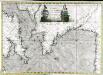
Carte de la Manche des costes de France
1 Karte auf 2 Blättern : Kupferdruck ; 51 x 72 cm Probst; Jäck; Ch chez Iean Michel Probst
Brittische Übermacht zur See wider Franckreich a.o 1759, in denen Unternehmungen derer Engelländer auf die französisch Küsten, nach denen besten Engl. u. Französischen Original Berichten und durch kostbahre Correspondence erhaltene Gewissheit
1 : 2500000 gezeichnet u. historisch erklähret durch Christian Fried. von der Heyden designée fort exactement et explicque par Chrétien Frédéric de Heyden ; gravé par M. A. Lotter, le fis in Augsp : verlegt von Tob. Conr. Lotter
Brittische Übermacht zur See wider Franckreich a.o 1759
1 Karte : Kupferdruck ; 46 x 36 cm, Bildgrösse 48 x 47 cm Heyden; Lotter; Lotter verlegt von Tob: Conr: Lotter
La Manche
1 Karte : Kupferdruck ; 50 x 61 cm Jefferys; Le Rouge chez Le Rouge géographe du roi rue des g.ds Augustins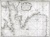
Carte de la Manche des costes de France
1 Karte : Kupferdruck ; 52 x 72 cm Huc; Ch chez le Sr. Huc
France I.
1 : 1800000 Society for the Diffusion of Useful Knowledge (Great Britain)
La Manche
1 Karte : Kupferdruck ; 50 x 61 cm Jefferys; Le Rouge chez Le Rouge géographe du roi rue des g.ds Augustins
Carte de la Manche
1 Karte : Kupferdruck ; 50 x 66 cm Lattré chéz Lattré graveur ordinaire du roi de M. le duc d'Orléans et de la ville rue St. Jacques la porte cochère en face de la rue de la Parcheminerie
Der Nord-Westliche Theil von Frankreich
Hand-Atlas über alle Theile der Erde nach dem neuesten Zustande und über das Weltgebäude Stieler, Adolf bei Justus Perthes
[Frankreich in 4 Blättern, Nordwestliches Frankreich]
Hand-Atlas über alle Theile der Erde und über das Weltgebäude Stieler, Adolf Justus Perthes
Britannia & Normandia cum confinibus regionibus [Karte], in: Gerardi Mercatoris Atlas, sive, Cosmographicae meditationes de fabrica mundi et fabricati figura, S. 220.
1 Karte aus Atlas Mercator, Gerhard Montanus, Petrus
Cartes et coupe du Canal de la Manche et d'une partie de la mer d'Allemagne qui présentent par une nouvelle méthode la pente du fonds de ces deux mers
1 Karte : Kupferdruck ; 16 x 23 cm, Blattgrösse 46 x 61 cm Buache Philippe Buache
Canalis inter Angliæ et Galliæ littora
1 Karte : Kupferdruck ; 48 x 55 cm Renard gedruckt by L. Renard
Manica, gallis la Manche, et belgis het Canaal, pars oceani inter Angliam et Gallicam
1 Karte : Kupferdruck ; 46 x 55 cm Visscher; Gouwen Nicolaes Visscher
32-34. Francia nord.
1 : 1500000 Touring club italiano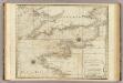
A chart of the British Channel.
1 : 1780000 Jefferys, Thomas
Carte de la France septentrionale
1 : 1000000 Collon delin. lith. de Jobard Frères [Bruxelles] : Jobard Frères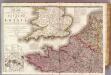
France 1.
1 : 1170000 Herisson, Eustache, b. 1759
Der Nord-Westliche Theil von Frankreich
Stieler's Hand-Atlas Stieler, Adolf bei Justus Perthes
La Manche.
1 : 4300000 Desmarest, Nicolas, 1725-1815
Pas caart van de canaal tusschen Engeland en Vrancrijck
1 Karte : Kupferdruck ; 43 x 53 cm Doncker by Hendrick Doncker boeckverkoper en graedbooghmaecker inde Nieuwbrugsteegh in 't Stuurmans gereedschap
France.
1 : 4400000 Vivien de St Martin, L.