Maps of New Aquitaine

Galliæ antiquæ descriptio geographica, 3
1 Blatt : 42 x 57 cm s.n.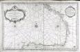
Carte reduite du golphe de Gascogne
1 Karte : Kupferdruck ; 53 x 84 cm Bellin s.n.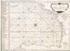
Accurate chart of the Bay of Biscay
Neptune Occidental. A Compleat Pilot for the West-Indies, including the British Channel, Bay of Biscay, and all the Atlantic islands; with their bays, harbours, keys, rocks, land-marks, depths of water, latitudes, longitudes &c. &c. ... Done from actual surveys, by the late Thomas Jefferys ... on twenty-eight large imperial plates. Jefferys, Thomas. London : Printed for R. Sayer and J. Bennett
Pas-caert van de bocht van Vranckrijck, Biscajen en Galissen; tusschen Heyssant en C. de Finisterre
1 Karte : Kupferdruck ; 42 x 53 cm Doncker bÿ Hendrick Doncker inde Nieuwbrug steegh in 't Stuurmans gereetschap
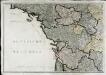
[Frankreich in 4 Blättern, Nordwestliches Frankreich]
Hand-Atlas über alle Theile der Erde und über das Weltgebäude Stieler, Adolf Justus Perthes
Britannia & Normandia cum confinibus regionibus [Karte], in: Gerardi Mercatoris Atlas, sive, Cosmographicae meditationes de fabrica mundi et fabricati figura, S. 220.
1 Karte aus Atlas Mercator, Gerhard Montanus, Petrus


Der Nord-Westliche Theil von Frankreich
Hand-Atlas über alle Theile der Erde nach dem neuesten Zustande und über das Weltgebäude Stieler, Adolf bei Justus Perthes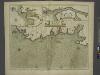
The sea coast of FRANCE from Ushent to Olone
from The sea-atlas : containing an hydrographical description of most of the sea-coasts of the known parts of the world.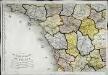
Carte de la république de France, no. 3
1 Blatt : 41 x 59 cm s.n.
Neueste Generalkarte von Frankreich, 3
1 Blatt : 55 x 78 cm F.A. Schrämbl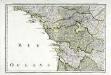
Troisieme feuille contenant une partie de la Bretagne, l'Anjou, la Touraine, le Poitou, la Saintonge, la Marche et le Limosin
1 Blatt : 34 x 55 cm Bourgoin
France Flle. Ouest.
1 : 1000000 Vivien St Martin, L.
France Régionale France de l’Ouest Normandie-Bretagne-Charentes carte politique
Gallois, Lucien
France Régionale France de l’Ouest Normandie-Bretagne-Charentes carte physique
Gallois, Lucien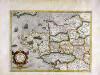
Britannia [et] Normandia cum confinib[us] regionibus
1 Karte : Kupferdruck ; 33 x 45 cm Mercator; Hondius Henricus Hondius
Britannia [et] Normandia cum confinib[us] regionibus
1 Karte : Kupferdruck ; 34 x 45 cm Hondius; Mercator Jodocus Hondius
Britannia [et] Normandia cum confinib[us] regionibus
1 Karte : Kupferdruck ; 33 x 45 cm Mercator s.n.
Der Nord-Westliche Theil von Frankreich
Stieler's Hand-Atlas Stieler, Adolf bei Justus Perthes
Schauplaz des Krieges der Vendeer und Chouans
1 Karte : Kupferdruck ; 36 x 40 cm Abel s.n.
Atlantischer Ozean
1 : 600000 Atlantský oceán Admiralität
Le royaume d'Aquitaine
1 Karte : Kupferdruck ; 40 x 49 cm, Bildgrösse 41 x 56 cm Duval chez l'auteur en l'isle du Palais sur le quay de l'Orloge au coin de la rüe de Harlay
A new an exact map of ey south west part of France
1 : 957000 Berry (Francie) Picard, Jean La Hire, Philippe de
Der Nord-Westliche Theil von Frankreich
Hand-Atlas über alle Theile der Erde nach dem neuesten Zustande und über das Weltgebäude Stieler, Adolf bei Justus Perthes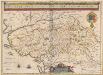
Pictaviae Ducatus Descriptio, Vulgo Le Pais De Poictou. [Karte], in: Novus Atlas, das ist, Weltbeschreibung, Bd. 2, S. 127.
1 Karte aus Atlas Blaeu, Joan Blaeu, Willem Janszoon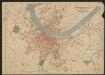
Poictou Pictaviensis Comitatus [Karte], in: Gerardi Mercatoris et I. Hondii Newer Atlas, oder, Grosses Weltbuch, Bd. 2, S. 110.
1 Karte aus Atlas Mercator, Gerhard und Hondius, Jodocus Jansson, Jan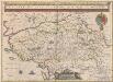
Pictaviae Ducatus Descriptio, Vulgo Le Pais De Poictou. [Karte], in: Theatrum orbis terrarum, sive, Atlas novus, Bd. 2, S. 116.
1 Karte aus Atlas Blaeu, Joan Blaeu, Willem Janszoon


