Maps of Bretagne
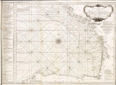
Accurate chart of the Bay of Biscay
Neptune Occidental. A Compleat Pilot for the West-Indies, including the British Channel, Bay of Biscay, and all the Atlantic islands; with their bays, harbours, keys, rocks, land-marks, depths of water, latitudes, longitudes &c. &c. ... Done from actual surveys, by the late Thomas Jefferys ... on twenty-eight large imperial plates. Jefferys, Thomas. London : Printed for R. Sayer and J. Bennett
Pas-caert van de bocht van Vranckrijck, Biscajen en Galissen; tusschen Heyssant en C. de Finisterre
1 Karte : Kupferdruck ; 42 x 53 cm Doncker bÿ Hendrick Doncker inde Nieuwbrug steegh in 't Stuurmans gereetschap
Galliæ, Biscajæ et Gallissiæ sinus
1 Karte : Kupferdruck ; 48 x 55 cm Renard gedruckt bÿ L. Renard
[131][134] Galliae, Biscajae et Gallissiae Sinus ... De Bocht van Vranckryck ..., uit: Atlas sive Descriptio terrarum orbis
Annotatie: Gedigitaliseerde versie. Amsterdam. Heiloo : Picturae (vervaardiger), 2015. tiff-bestand. Gedigitaliseerd: 07-01-2015; Origineel: Universiteitsbibliotheek Vrije Universiteit (XL.05127.-) ; Netherlands; Titelpagina ontbreekt Wit, Frederik de Amsterdam : Frederick de Wit
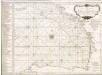
A large chart of the BAY OF BISCAY
from The sea-atlas : containing an hydrographical description of most of the sea-coasts of the known parts of the world.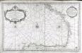
Carte reduite du golphe de Gascogne
1 Karte : Kupferdruck ; 53 x 84 cm Bellin s.n.
Partie, l'Espagne. Europe 18.
1 : 1641836 Vandermaelen, Philippe, 1795-1869
Galliæ antiquæ descriptio geographica, 3
1 Blatt : 42 x 57 cm s.n.
Atlantischer Ozean
1 : 600000 Atlantský oceán Admiralität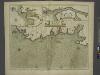
The sea coast of FRANCE from Ushent to Olone
from The sea-atlas : containing an hydrographical description of most of the sea-coasts of the known parts of the world.
Le royaume d'Aquitaine
1 Karte : Kupferdruck ; 40 x 49 cm, Bildgrösse 41 x 56 cm Duval chez l'auteur en l'isle du Palais sur le quay de l'Orloge au coin de la rüe de Harlay
France Flle. Ouest.
1 : 1000000 Vivien St Martin, L.
A new an exact map of ey south west part of France
1 : 957000 Berry (Francie) Picard, Jean La Hire, Philippe de
Carte de la France, 3
1 Blatt : 61 x 83 cm de Belleyme
Carte de la France, 3
1 Blatt : mehrfarbig ; 61 x 83 cm de Belleyme
Carte de la France, 3
1 Blatt : 61 x 82 cm de Belleyme
France S.O.
1 : 1615000 Migeon, J.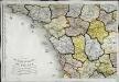
Carte de la république de France, no. 3
1 Blatt : 41 x 59 cm s.n.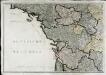
Neueste Generalkarte von Frankreich, 3
1 Blatt : 55 x 78 cm F.A. Schrämbl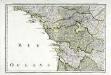
Troisieme feuille contenant une partie de la Bretagne, l'Anjou, la Touraine, le Poitou, la Saintonge, la Marche et le Limosin
1 Blatt : 34 x 55 cm Bourgoin
Frankreich In 4 Blattern. Blatt 3.
1 : 1500000 Vogel, C.
[Frankreich, Blatt 3]
Adolf Stieler's Handatlas über alle Theile der Erde und über das Weltgebäude Stieler, Adolf Justus Perthes
[Frankreich in 4 Blättern, Blatt 3]
Handatlas über alle Theile der Erde und über das Weltgebäude Stieler, Adolf Justus Perthes
Carte de la France (SO)
1 : 345600 Cassini family

Carte de France, 5
2 Blätter : Kupferdruck ; 53 x 44 cm Crepy
Karte von Frankreich in XVI Blättern, No. 9 und [No. 13]
2 Blätter : 52 x 33 cm Königl. Preuss. Academischen Kunst und Buchhandlung
Bourdelois, Pays De Medoc, Et La Prevoste De Born. [Karte], in: Novus atlas absolutissimus, Bd. 4, S. 162.
1 Karte aus Atlas Janssonius Offizin
Tabula ducatus Brittaniae Gallis
1 : 511000 Bretaň (Francie) Homann, Johann Baptist Ioh. Bapt. Homanno