Maps of Switzerland
Karte der Eisenbahnen Deutschlands
1 : 700000 Südwest-Blatt Stich, Druck u. Verlag des lithographischen Instituts von Aug. Wehrt
195. Karwendel, uit: Topographische Uebersichtskarte des Deutschen Reiches / herausgegeben v. d. Kartogr. Abt. d. Königl. Preuß. Landesaufnahme
1 : 200000 titelvariant: Topogr. Übersichtskarte des Deutschen Reiches; Annotatie: Titel boven bladen ook: Topogr. Übersichtskarte des Deutschen Reiches; Annotatie geografische gegevens: Op elk blad twee maatstokken: 10 Kilometer = 5,5 cm; 1 geogr. Meile = 3,6 cm; Legenda onder op elk blad Königlich Preußische Landesaufnahme. Kartographische Abtheilung [S.l : Königlich Preußische Landesaufnahme, Kartographische Abtheilung]
Bibliopolische Karte von Süddeutschland
Frankfurt nad Mohanem (Německo)
Höhen Charte oder bildlich vergleichende Uebersicht der bedeutendesten Berge in Deutschland und der Schweiz
1 : 22000 Německo Weiland, Karl Ferdinand Geograph. Institut
Nova Germaniae
1 : 3420000 Belgie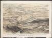
Stannard & Son's, panoramic birds-eye view of the French & Prussian provinces, on the banks of the Rhine, shewing all the fortresses belonging to each army, with the railways & frontier boundaries of each country
1 : 1
Westdeutsches Mittelgebirge
Plastischer Schul-Atlas über alle Theile der Erde : in 24 Karten Woldermann, G Verlag von P. Eckerlein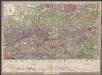
Le Cours De La Riviere Du Rhein depuis sa Source jusques a son Emboucheure [...] [Karte], in: Atlas nouveau, contenant toutes les parties du monde [...], Bd. 1, S. 166.
1 Karte aus Atlas Sanson, Nicolas Jaillot, Alexis Hubert und Mortier, Pieter
Carte des principaux points du théatre de la guerre présente sur le frontieres d'Allemagne et de Pays-Bas
1 : 2200000 Francie Bouge, Jean-Baptiste de chez J. B. de Bouge
Baden.
1 : 670000 Flemming, Carl
Totius Rheni ab ejus capitibus ad Oceanum usque Germanicum in quem se exonerat Novißima Descriptio
1 : 810000 Mollova mapová sbírka Janssonius, Johannes Janssonius, Johannes I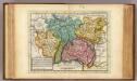
The south west part of Germany.
1 : 2400000 Moll, Herman, d. 1732

[Frankreich, Blatt 2]
Adolf Stieler's Handatlas über alle Theile der Erde und über das Weltgebäude Stieler, Adolf Justus Perthes
German Empire 3.
1 : 1774080 Letts, Son & Co.
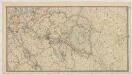
Composite: Sud-West Deutschland, Schweiz.
1 : 925000 Vogel, C.

Belli ab obitu Caroli VI. Imperatoris usqve ad pacem Dresdae d. 25. Dec. MDCCXLV
1 : 1300000 Mollova mapová sbírka Kraus, Lorenz Jacob Homann, Johann Baptista - dědici
Kriegs - Karte 1870

Germany. Deutschland III.
1 : 1760000 Society for the Diffusion of Useful Knowledge (Great Britain)
Sudwestliches Deutschland
1 : 1850000 Stieler, Adolf
Kriegs-Karte 1870
1 : 1000000 Belgie Eduard Hallberger
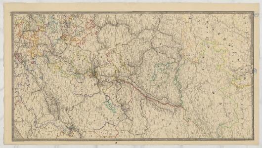
Südwestliches Deutschland und Schweiz
Schul-Atlas über alle Theile der Erde nach dem neuesten Zustande, und über das Weltgebäude Stieler, Adolf bei Justus Perthes
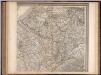
Süd-Westliches Deutschland und die Schweiz
Hand-Atlas über alle Theile der Erde und über das Weltgebäude Stieler, Adolf Justus Perthes
Tabula geographica qua pars septentrionalis sive Inferior Rheni, Mosae, et Mosellae, maximaeque partes Visurgis, Moeni, Amasi, Scaldis, Isalae, et alia in eosdem inluentia flumina, nec non provinciae Germaniae inferioris, Westphaliae, Hassiae, archiepiscopatus et electoratus Coloniensis ac Trevirensis, cum partibus Moguntini, et Palatinus Rheni, et aliae regiones adjacentes
1 : 1000000 accuratissime ostenduntur per Nicolaum Visscher Amst. Bat. Amst[elodami] Bat[avorum] : nunc apud Petrum Schenk Jun.
Süd-Westliches Deutschland und die Schweiz
Handatlas über alle Theile der Erde und über das Weltgebäude Stieler, Adolf Justus Perthes
Suisse
1 : 3500000 1 Karte [Alain Manesson Mallet] [in verlegung Johann David Zunners], [Franckfurt am Mayn]
SW pt. of Germany.
1 : 2300000 Bowen, Emanuel
Südwestliches Deutschland, enth. Bayern, Würtemberg, Baden, Hohenzollern und Schweiz
Hand-Atlas über alle Theile der Erde nach dem neuesten Zustande und über das Weltgebäude Stieler, Adolf bei Justus Perthes