Maps of Switzerland

Composite: Sud-West Deutschland, Schweiz.
1 : 925000 Vogel, C.
Karte der Eisenbahnen Deutschlands
1 : 700000 Südwest-Blatt Stich, Druck u. Verlag des lithographischen Instituts von Aug. Wehrt
Kriegs - Karte 1870

Kriegs-Karte 1870
1 : 1000000 Belgie Eduard Hallberger
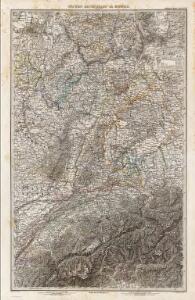
Sudwestliches Deutschland
1 : 1850000 Stieler, Adolf

Südwestliches Deutschland, enth. Bayern, Würtemberg, Baden, Hohenzollern und Schweiz
Hand-Atlas über alle Theile der Erde nach dem neuesten Zustande und über das Weltgebäude Stieler, Adolf bei Justus Perthes
The south west part of Germany.
1 : 2400000 Moll, Herman, d. 1732
[Südwestliches Deutschland und Schweiz]
Stieler's Hand-Atlas Stieler, Adolf bei Justus Perthes
Südwestliches Deutschland, enth. Bayern, Würtemberg, Baden, Hohenzollern und Schweiz
Hand-Atlas über alle Theile der Erde nach dem neuesten Zustande und über das Weltgebäude Stieler, Adolf bei Justus Perthes
Frankreich In 4 Blattern, Blatt 2.
1 : 1500000 Vogel, C.
[Frankreich in 4 Blättern, Blatt 2]
Handatlas über alle Theile der Erde und über das Weltgebäude Stieler, Adolf Justus Perthes
Totius Fluminis Rheni Novissima Descriptio [Karte, Teil 1], in: Novus atlas absolutissimus, Bd. 2, S. 150.
1 Karte aus Atlas Janssonius Offizin
Jiho-západní Německo a Šwejcary
1 : 3300000 Německo jihozápadní Merklas, Václav
Armoiries des XIII cantons et des alliés
1 : 2500000 1 Karte [Chenebié], [Vevey]
SW pt. of Germany.
1 : 2300000 Bowen, Emanuel
[Schweiz]
1 : 2100000 1 Karte [von Johann Gerhard Reinhard Andreae] [bei Joh. Caspar Füessli Sohn, und in Commission bei Heinrich Steiner und Comp. Buchhändlern], [Winterthur]
Totius Rheni ab ejus capitibus ad Oceanum usque Germanicum in quem se exonerat Novißima Descriptio
1 : 810000 Mollova mapová sbírka Janssonius, Johannes Janssonius, Johannes I
[Southwest Germany]
1 : 1400000 [S.l. : s.n.]
Land Charte zum Schau Platz des Kriegs der Röm Kaiserl Maje und dero hohen Alliirten am Rhein
1 : 840000 Mollova mapová sbírka Riegel, Christoph Riegel, Christoph
Helvetiae descriptio
1 Karte : Kupferdruck ; 34 x 44 cm Tschudi; Ortelius s.n.
Helvetiae descriptio
1 Karte : Kupferdruck ; 35 x 45 cm Tschudi; Ortelius s.n.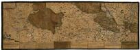
Rhenus Bicornis hoc est Totius Rheni tractus delineatio
Mollova mapová sbírka Vopel, Caspar Tscherning, Johann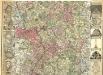
Rhenus per tres Tabellas delineatus
1 : 330000 Mollova mapová sbírka Michal, Jacques de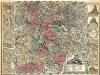
Rhenus per tres Tabellas delineatus
1 : 330000 Mollova mapová sbírka Michal, Jacques de
Rhenus per tres Tabellas delineatus
1 : 330000 Mollova mapová sbírka Michal, Jacques de
Bern
1 : 500000 Gotha : Justus Perthes
Carte von Lottringen Elsass Franche Comte Schweizerland und Würtenberg
1 Karte : Kupferdruck ; 47 x 62 cm Riegel Christoph Riegel
<<Die>> erst Tafel innhaltend das Schweytzerlandt mit anstossenden Ländern
1 : 750000 1 Karte [Sebastian Münster] [Henricpetri], [Basel]