Maps of Germany


[Historisch-geographischer Atlas zu den allgemeinen Geschichtswerken von C. v. Rotteck, Pölitz u. Becker] : Deutschland als Rheinbund während der Napoleonischen Kaiserherrschaft
von Julius Loewenberg Lithographie von B. Herder in Freiburg im Breisgau [Freiburg im Breisgau] : [Herder]
[Historisch-geographischer Atlas zu den allgemeinen Geschichtswerken von C. v. Rotteck, Pölitz u. Becker] : Deutschland als Staatenbund seit dem Pariser Frieden 1814
von Julius Loewenberg Lithographie von B. Herder in Freiburg im Breisgau [Freiburg im Breisgau] : [Herder]
56-57. Germania sud, Austria.
1 : 1500000 Touring club italiano
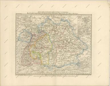
Etats Secondaires de L'Allemagne.
Andriveau-Goujon, J.
Rheinbund 10. Januar 1810
Deutschland Rheinbund Kunz, Andreas ; Moeschl, Joachim Robert
Germania benedictina qvae in illa sunt monasteria ord. S. Benedicti monstrans
1 : 2400000 Itálie severní Homannianos Heredes
Rheinbund 12. Juli 1806
Deutschland Rheinbund Kunz, Andreas ; Moeschl, Joachim Robert
Composite I, II, VI, VII: Karte Des Oesterreichischen Kaiserstaates.
1 : 576000 Scheda, Josef
Allemagne du Sud, Autriche.
1 : 1500000 Vivien St Martin, L.
Charte von Deutschland nach der neuesten Begränzung
Evropa střední J. Riedl's Kunsthandlung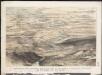
Stannard & Son's, panoramic birds-eye view of the French & Prussian provinces, on the banks of the Rhine, shewing all the fortresses belonging to each army, with the railways & frontier boundaries of each country
1 : 1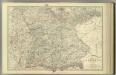
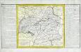
Empire of Germany (southern portion).
1 : 1050000 Johnston, Alexander Keith
Rheinbund 1812
Deutschland Rheinbund Hundt, Michael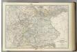
Empire of Germany (southern portion).
1 : 1050000 Johnston, Alexander Keith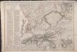
Carte du Théâtre de la Guerre en Allemagne, en Autriche et en Italie; où se trouvent tracés les Marches, Positions, Batailles et Combats, de la Grande-Armée, commandée en personne par S. M. l'Empereur Napoléon; pendant la Campgane de 1805, et ceux de l'Armée d'Italie, commandée par S. Ex. le Maréchal Masséna
Picquet, Charles; Magimel, Denis-Simon
[Das Deutsches Reich, Blatt 3]
Adolf Stieler's Handatlas über alle Theile der Erde und über das Weltgebäude Stieler, Adolf Justus Perthes
Plan qui réuni les duchés de Julier, et de Berg, le palatinat du Rhin, les duchés de Baviere et de Neubourg, sans y comprendre le marquisat de Berg op Zoom
1 : 1250000 par son très humble, très soumis, et très obeisant serviteur De St. Michel, Ingenieur A Augsbourg : publié par les freres Lotter
Schiffahrtsstraßen in Deutschland Stand 1989
Deutschland Wasserstraße, Binnenschifffahrt Kunz, Andreas ; Moeschl, Joachim Robert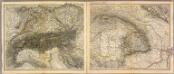
Alpen- u. Donaulaender.
1 : 1900000 Stein, Christ. Gottfr. Dan.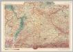
Germany - South. Pergamon World Atlas.
1 : 1250000 Polish Army Topography Service
Karte des Oesterreichisch - ungarischen Reiches
Cercle de Souabe
1 Karte : Kupferdruck ; 29 x 32 cm, Bildgrösse 31 x 55 cm Clouet Mondhare
Bibliopolische Karte von Süddeutschland
Frankfurt nad Mohanem (Německo)
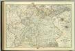
Empire of Germany (southern portion).
1 : 1050000 Johnston, W. & A.K.
Sud-Westliches Deutschland Und Die Schweiz.
1 : 1850000 Vogel, C.
Blatt 97: Metzingen, uit: Topographische Karte von Württemberg im Massstab 1:25.000 / hrsg. vom Statistischen Landesamt
1 : 25000 titelvariant: Topographische Karte des Königreichs Württemberg im Massstabe 1:25.000; Annotatie: Titelvariant: Topographische Karte des Königreichs Württemberg im Massstabe 1:25.000; Incompleet (4 bl. aanwezig) Württembergisches Statistisches Landesamt [Stuttgart : Statistisches Landesamt]
Länder der Bundesrepublik 1989
Deutschland, Bundesrepublik Kunz, Andreas ; Moeschl, Joachim Robert