Maps of Germany

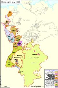
Rheinbund 12. Juli 1806
Deutschland Rheinbund Kunz, Andreas ; Moeschl, Joachim Robert
Rheinbund 10. Januar 1810
Deutschland Rheinbund Kunz, Andreas ; Moeschl, Joachim Robert
Germany.
1 : 3651000 Fisher, Richard Swainson
Charte von dem Rheinischen Bunde und den angränzenden Ländern nach der gegenwärtigen Eintheilung
1 : 1000000 Evropa střední Kunst und Industrie Comptoir
Germania vetus
1 : 5130000 Evropa střední Bonne, Rigobert André
Kriegsschauplatz im Jahre 1813
Evropa střední Kunst und Industrie Comptoir
Neueste Karte von Deutschland, der Schweiz und Ober-Italien in 4 Blättern
1 : 1700000 Itálie severní Ravenstein, L. Bibl. Institut
Charte von Deutschland nach der neuesten Begränzung
Evropa střední J. Riedl's Kunsthandlung
An Accurate Map of Germany
Mollova mapová sbírka Bennett Dilly, Charles
Karte der Deutschen Bundesstaaten
1 : 3000000 Evropa střední Fried, Franz Artaria
Karte der Deutschen Bundesstaaten
1 : 3000000 Evropa střední Fried, Franz Artaria & Compag.
Duytsland in 9 Kraitzen of Circels Nevens de Keyserlyke Erflanden verdeelt
1 : 6900000 Mollova mapová sbírka Ottens, Reinier Ottens, Josua
Duytsland in 9 Kraitzen of Circels Nevens de Keyserlyke Erflanden verdeelt
1 : 6900000 Mollova mapová sbírka Schenk, Pieter Schenk, Peter II
Post- und Eisenbahn- Karte von Deutschland
1 : 3800000 Evropa střední Wagner, Jan Eduard Kohl, Johann Georg Wagner u. Kohl
Charte von Deutschland
Evropa střední Berra, Marco Marco Berra
[Historisch-geographischer Atlas zu den allgemeinen Geschichtswerken von C. v. Rotteck, Pölitz u. Becker] : Deutschland als Rheinbund während der Napoleonischen Kaiserherrschaft
von Julius Loewenberg Lithographie von B. Herder in Freiburg im Breisgau [Freiburg im Breisgau] : [Herder]
Karte von Deutschland, in IV Blättern entworfen im Jahre 1805, und nach den, durch die Bundesacte der Reinschen Conföderation, datirt Paris vom 12ten Julius 1806, ingleichen nach den, durch die verschiedenen Tausch- und Pacifications Verträge
1 : 875000
[Historisch-geographischer Atlas zu den allgemeinen Geschichtswerken von C. v. Rotteck, Pölitz u. Becker] : Deutschland als Staatenbund seit dem Pariser Frieden 1814
von Julius Loewenberg Lithographie von B. Herder in Freiburg im Breisgau [Freiburg im Breisgau] : [Herder]
Germanic Confederation.
1 : 3700000 Cornell, S. S. (Sarah S.)
Eisenbahn Karte von Deutschland u. den angrenzenden Ländern
Evropa střední J.B. Hirschfeld
Germany.
1 : 3674880 Johnson, A.J.
Germany.
1 : 7200000 Seaman, James V.
Rheinbund 1812
Deutschland Rheinbund Hundt, Michael
Carte de l'Empire d'Alemagne
1 : 2900000 Mollova mapová sbírka Duval, Pierre Duval, Pierre
Charte von Deutschland nach den besten Hülfsmitteln gezeichnet, dem Pariser Frieden erweitert und gemäss der Beschlüsse des Wiener Congresses begränzt
1 : 1750000 von Friedr. Wilh. Streit Nürnberg : Friedrich Campe
Carte des Havlte et Basse Allemagne
Evropa střední Langlois, N. N. Langlois
Empire of Germany and the 13 Cantons of Switzerland.
1 : 2700000 Carey, Mathew
Empire of Germany with the 13 Cantons of Switzerland.
1 : 2700000 Carey, Mathew
Empire of Germany with the 13 Cantons of Switzerland.
1 : 2700000 Carey, Mathew