Maps of Bavaria

Sud-Westliches Deutschland Und Die Schweiz.
1 : 1850000 Vogel, C.
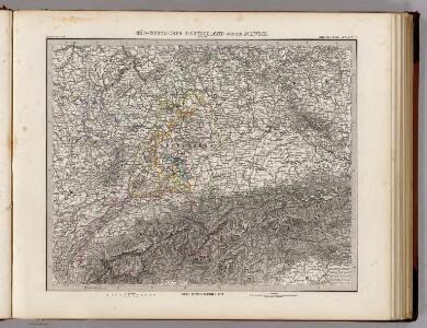
Süd-Westliches Deutschland und die Schweiz
Handatlas über alle Theile der Erde und über das Weltgebäude Stieler, Adolf Justus Perthes
Süd-Westliches Deutschland und die Schweiz
Hand-Atlas über alle Theile der Erde und über das Weltgebäude Stieler, Adolf Justus Perthes
Sudwestliches Deutschland
1 : 1850000 Stieler, Adolf
Südwestliches Deutschland und Schweiz
Schul-Atlas über alle Theile der Erde nach dem neuesten Zustande, und über das Weltgebäude Stieler, Adolf bei Justus Perthes
Südwestliches Deutschland, enth. Bayern, Würtemberg, Baden, Hohenzollern und Schweiz
Hand-Atlas über alle Theile der Erde nach dem neuesten Zustande und über das Weltgebäude Stieler, Adolf bei Justus Perthes
[Südwestliches Deutschland und Schweiz]
Stieler's Hand-Atlas Stieler, Adolf bei Justus Perthes

Südwestliches Deutschland, enth. Bayern, Würtemberg, Baden, Hohenzollern und Schweiz
Hand-Atlas über alle Theile der Erde nach dem neuesten Zustande und über das Weltgebäude Stieler, Adolf bei Justus Perthes
German Empire 3.
1 : 1774080 Letts, Son & Co.
Jiho-západní Německo a Šwejcary
1 : 3300000 Německo jihozápadní Merklas, Václav
Germany. Deutschland III.
1 : 1760000 Society for the Diffusion of Useful Knowledge (Great Britain)
Cercle de Souabe
1 Karte : Kupferdruck ; 29 x 32 cm, Bildgrösse 31 x 55 cm Clouet Mondhare

Bibliopolische Karte von Süddeutschland
Frankfurt nad Mohanem (Německo)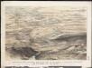
Stannard & Son's, panoramic birds-eye view of the French & Prussian provinces, on the banks of the Rhine, shewing all the fortresses belonging to each army, with the railways & frontier boundaries of each country
1 : 1
Suevia Et Bavaria XI. Nova Tabula. [Karte], in: Claud. Ptolemaeus. Geographia lat. cum mappis [...], S. 380.
1 Karte aus Atlas Münster, Sebastian [und Ptolemaeus, Claudius]
Germany (Deutschland)
1 : 1750000 Bavorsko (Německo) Baldwin & Cradock
Composite I, II, VI, VII: Karte Des Oesterreichischen Kaiserstaates.
1 : 576000 Scheda, Josef
Souabe, Baviere.
1 : 2900000 Clouet, J. B. L. (Jean-Baptiste Louis), b. 1730
Das Königreich Baiern
Allgemeiner Atlas [Walch, Johannes] im Verlag bei Johannes Walch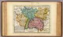
The south west part of Germany.
1 : 2400000 Moll, Herman, d. 1732
[Das Deutsches Reich, Blatt 3]
Adolf Stieler's Handatlas über alle Theile der Erde und über das Weltgebäude Stieler, Adolf Justus Perthes
Suevia Et Bavaria XII. Nova Tabula. [Karte], in: Claud. Ptolemaeus. Geographia lat. cum mappis [...], S. 383.
1 Karte aus Atlas Münster, Sebastian [und Ptolemaeus, Claudius]
Suevia Et Bavaria XI. Nova Tabula. [Karte], in: Geographia universalis vetus et nova complectens Claudii Ptolemaei Alexandrini enarrationis libros VIII, S. 329.
1 Karte aus Atlas Münster, Sebastian [und Ptolemaeus, Claudius]
Raetiae veteris exterae et hodiernae una cum regionibus ei guondam [i.e. quondam] adnumeratis & finitimarum regionum limitibus tabula generalis
1 : 1100000 1 Karte Matth. Hirtzg. ; Leo. Scherer [Joh. Rodolff Wolffen], [Zürich]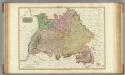
Germany south of the Mayn.
1 : 885000 Pinkerton, John, 1758-1826
[Atlas zur Geschichte von Bayern] : I. Rhaetia, Noricum und die angränzenden Länder
K. v. Spruner [Gotha : Perthes]
Plan qui réuni les duchés de Julier, et de Berg, le palatinat du Rhin, les duchés de Baviere et de Neubourg, sans y comprendre le marquisat de Berg op Zoom
1 : 1250000 par son très humble, très soumis, et très obeisant serviteur De St. Michel, Ingenieur A Augsbourg : publié par les freres Lotter