Maps of Germany
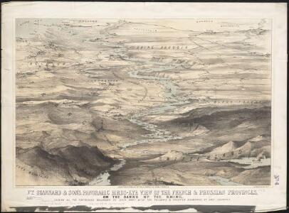
Stannard & Son's, panoramic birds-eye view of the French & Prussian provinces, on the banks of the Rhine, shewing all the fortresses belonging to each army, with the railways & frontier boundaries of each country
1 : 1
Bibliopolische Karte von Süddeutschland
Frankfurt nad Mohanem (Německo)
Germany-Czechoslovakia-Poland
Germany-Czechoslovakia-Poland [Aerodromes, Landing grounds, Seaplane bases], ADI (Maps) AM 8058A. [S.l.] : Air Ministry, United Kingdom
Die Ältesten Karten von Deutschland

Duytsland in 9 Kraitzen of Circels Nevens de Keyserlyke Erflanden verdeelt
1 : 6900000 Mollova mapová sbírka Ottens, Reinier Ottens, Josua
Duytsland in 9 Kraitzen of Circels Nevens de Keyserlyke Erflanden verdeelt
1 : 6900000 Mollova mapová sbírka Schenk, Pieter Schenk, Peter II
Carta Generale di tutta Alemagna, e Paesi circonuicini
Mollova mapová sbírka Gualdo Priorato, Galeazzo
[Historisch-geographischer Atlas zu den allgemeinen Geschichtswerken von C. v. Rotteck, Pölitz u. Becker] : Deutschland als Staatenbund seit dem Pariser Frieden 1814
von Julius Loewenberg Lithographie von B. Herder in Freiburg im Breisgau [Freiburg im Breisgau] : [Herder]
Etats Secondaires de L'Allemagne.
Andriveau-Goujon, J.
[Historisch-geographischer Atlas zu den allgemeinen Geschichtswerken von C. v. Rotteck, Pölitz u. Becker] : Deutschland als Rheinbund während der Napoleonischen Kaiserherrschaft
von Julius Loewenberg Lithographie von B. Herder in Freiburg im Breisgau [Freiburg im Breisgau] : [Herder]
Germany.
1 : 3651000 Fisher, Richard Swainson
Germany, W. sheet.
1 : 1400000 Rand McNally and Company
Charte von Deutschland zu dem Meilen-Zeiger
1 : 222000 Německo Schreiber, Johann Georg
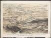
Birds eye view of the seat of War in Europe
1 : 1
Germany.
1 : 1788000 Hammond, C.S.
Rheinbund 10. Januar 1810
Deutschland Rheinbund Kunz, Andreas ; Moeschl, Joachim Robert
Rheinbund 12. Juli 1806
Deutschland Rheinbund Kunz, Andreas ; Moeschl, Joachim Robert
Central Europe.
1 : 2000000 Hughes, William
Rheinbund 1812
Deutschland Rheinbund Hundt, Michael
Schiffahrtsstraßen in Deutschland Stand 1989
Deutschland Wasserstraße, Binnenschifffahrt Kunz, Andreas ; Moeschl, Joachim Robert
Länder der Bundesrepublik 1955
Deutschland, Bundesrepublik Kunz, Andreas ; Moeschl, Joachim Robert
Special-Karte der west-norddeutschen Bundesstaaten
Le Rhin
1 : 1600000 Dubail, Edmond 1851-1934 Paris : imp. Monrocq
Germaniae, Galliae & Rhaetiae pars
1 : 2850000 Galie Heimburger, August Bibliographisches Institut
Geschichtl. Entwicklung des Königr. Preussen bis zum Frieden von Tilsit (1807)
Deutschland, Preußen, Tilsit / Friede
Western Germany.
1 : 1340000 Arrowsmith, John
Charte von Deutschland nach der neuesten Begränzung
Evropa střední J. Riedl's Kunsthandlung
Allemagne.
1 : 1850000 Brue, Adrien Hubert, 1786-1832
Länder der Bundesrepublik 1989
Deutschland, Bundesrepublik Kunz, Andreas ; Moeschl, Joachim Robert