Maps of Grand Est
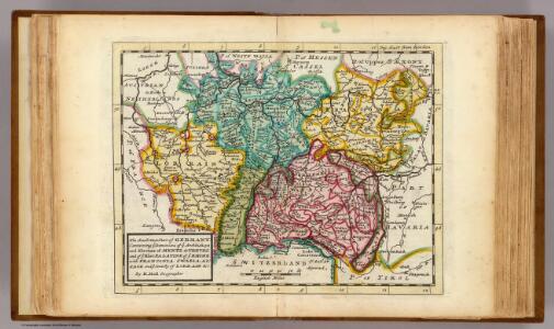
The south west part of Germany.
1 : 2400000 Moll, Herman, d. 1732
Südwestliches Deutschland und Schweiz
Schul-Atlas über alle Theile der Erde nach dem neuesten Zustande, und über das Weltgebäude Stieler, Adolf bei Justus Perthes
Süd-Westliches Deutschland und die Schweiz
Hand-Atlas über alle Theile der Erde und über das Weltgebäude Stieler, Adolf Justus Perthes
Carte des principaux points du théatre de la guerre présente sur le frontieres d'Allemagne et de Pays-Bas
1 : 2200000 Francie Bouge, Jean-Baptiste de chez J. B. de Bouge

Kriegs-Karte 1870
1 : 1000000 Belgie Eduard Hallberger
Süd-Westliches Deutschland und die Schweiz
Handatlas über alle Theile der Erde und über das Weltgebäude Stieler, Adolf Justus Perthes
[Frankreich, Blatt 2]
Adolf Stieler's Handatlas über alle Theile der Erde und über das Weltgebäude Stieler, Adolf Justus Perthes
Sudwestliches Deutschland
1 : 1850000 Stieler, Adolf
Sud-Westliches Deutschland Und Die Schweiz.
1 : 1850000 Vogel, C.
Kriegs - Karte 1870

Totius Rheni ab ejus capitibus ad Oceanum usque Germanicum in quem se exonerat Novißima Descriptio
1 : 810000 Mollova mapová sbírka Janssonius, Johannes Janssonius, Johannes I
Südwestliches Deutschland, enth. Bayern, Würtemberg, Baden, Hohenzollern und Schweiz
Hand-Atlas über alle Theile der Erde nach dem neuesten Zustande und über das Weltgebäude Stieler, Adolf bei Justus Perthes
Südwestliches Deutschland, enth. Bayern, Würtemberg, Baden, Hohenzollern und Schweiz
Hand-Atlas über alle Theile der Erde nach dem neuesten Zustande und über das Weltgebäude Stieler, Adolf bei Justus Perthes
[Südwestliches Deutschland und Schweiz]
Stieler's Hand-Atlas Stieler, Adolf bei Justus Perthes
The South West Part of Germany
1 : 2400000 Mollova mapová sbírka Moll, Herman Moll, Hermann
Karte der Eisenbahnen Deutschlands
1 : 700000 Südwest-Blatt Stich, Druck u. Verlag des lithographischen Instituts von Aug. Wehrt
SW pt. of Germany.
1 : 2300000 Bowen, Emanuel
German Empire 3.
1 : 1774080 Letts, Son & Co.
Neue vollkomene Landkarten des h. Röm. Reichs, Ober und Nieder Rheinisch- Fränkisch- Schwäbisch- und theils Bayrischen Kraises, samt denenselber angelegner Orten, an einem und dann Anderntheils, derer dem röm. Reich, durch Franckreich in dem vergangen und noch lauffenden Seculo entzogenen Ländern, Elsaß, Lothring, Burgund, Metz, Toul, Verdun, nicht weniger denen neu gemachten dependentien mit Anmerkung aller vornehmer Ort und Vöstungen, vornemlich am Rhein-Strom, von Basell, bis unterhalb Cölln etc. etc
1 : 1100000 Alsasko (Francie) Endter, Martin Martin Endter
Höhen Charte oder bildlich vergleichende Uebersicht der bedeutendesten Berge in Deutschland und der Schweiz
1 : 22000 Německo Weiland, Karl Ferdinand Geograph. Institut
Suisse
1 : 3500000 1 Karte [Alain Manesson Mallet] [in verlegung Johann David Zunners], [Franckfurt am Mayn]
Neue Vollkomene Landkarten. Des Röm: Reichs Ober und Nider Rheinisch-Fränkisch-Schwäbisch- und theils Bayrischen Kraises, samt denenselber etc angelegner Orten an einem Und dann Anderntheils, derer dem Röm: Reich, durch Franckreich in dem vergangen und noch laufenden Seculo entzogenen Ländern, Elsaß, Lothring, Burgund, Metz, Toul, Verdün
Mollova mapová sbírka
Frankreich In 4 Blattern, Blatt 2.
1 : 1500000 Vogel, C.
Germany. Deutschland III.
1 : 1760000 Society for the Diffusion of Useful Knowledge (Great Britain)
Jiho-západní Německo a Šwejcary
1 : 3300000 Německo jihozápadní Merklas, Václav
[Frankreich in 4 Blättern, Blatt 2]
Handatlas über alle Theile der Erde und über das Weltgebäude Stieler, Adolf Justus Perthes
Composite: Sud-West Deutschland, Schweiz.
1 : 925000 Vogel, C.
Provinciae Helveticae imago
1 : 1500000 1 Karte [neu bearb. von Giovanni Battista de Cassini] ; F.M.A.C. Dionantensis sculpsit [Ambrosius Ramellatus], [Mailand]