Maps of Bavaria

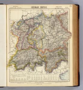
German Empire 3.
1 : 1774080 Letts, Son & Co.
Germany. Deutschland III.
1 : 1760000 Society for the Diffusion of Useful Knowledge (Great Britain)
Germany (Deutschland)
1 : 1750000 Bavorsko (Německo) Baldwin & Cradock
Südwestliches Deutschland, enth. Bayern, Würtemberg, Baden, Hohenzollern und Schweiz
Hand-Atlas über alle Theile der Erde nach dem neuesten Zustande und über das Weltgebäude Stieler, Adolf bei Justus Perthes
Sudwestliches Deutschland
1 : 1850000 Stieler, Adolf

[Südwestliches Deutschland und Schweiz]
Stieler's Hand-Atlas Stieler, Adolf bei Justus Perthes
Südwestliches Deutschland, enth. Bayern, Würtemberg, Baden, Hohenzollern und Schweiz
Hand-Atlas über alle Theile der Erde nach dem neuesten Zustande und über das Weltgebäude Stieler, Adolf bei Justus Perthes
Südwestliches Deutschland und Schweiz
Schul-Atlas über alle Theile der Erde nach dem neuesten Zustande, und über das Weltgebäude Stieler, Adolf bei Justus Perthes
Süd-Westliches Deutschland und die Schweiz
Hand-Atlas über alle Theile der Erde und über das Weltgebäude Stieler, Adolf Justus Perthes
Süd-Westliches Deutschland und die Schweiz
Handatlas über alle Theile der Erde und über das Weltgebäude Stieler, Adolf Justus Perthes
Sud-Westliches Deutschland Und Die Schweiz.
1 : 1850000 Vogel, C.
Raetiae veteris exterae et hodiernae una cum regionibus ei guondam [i.e. quondam] adnumeratis & finitimarum regionum limitibus tabula generalis
1 : 1100000 1 Karte Matth. Hirtzg. ; Leo. Scherer [Joh. Rodolff Wolffen], [Zürich]
Carta noua accurata del paßagio et strada dalli Paesi Baßi per via de Allemagna per Italia et per via di paesi Suizeri a Geneua, Lione et Roma per seruizio delli marchanti et viagianti in gen.ale ad instanza delli Ss. scherer et di Momforti speditori delli marchantie in Bregens
1 : 2060000 Itálie Wit, Frederik de Frederico de Wit
Jiho-západní Německo a Šwejcary
1 : 3300000 Německo jihozápadní Merklas, Václav
Souabe, Baviere.
1 : 2900000 Clouet, J. B. L. (Jean-Baptiste Louis), b. 1730
Karte von Deutschland in IV Blättern
1 : 825000 Südwest-Blatt Sotzmann, Daniel Friedrich im Verlage der A. G. Schneider und Weigels
Bibliopolische Karte von Süddeutschland
Frankfurt nad Mohanem (Německo)

Süddeutschland
Volksschul-Atlas über alle Teile der Erde Lange, Henry Druck und Verlag von Georg Westermann
Cercle de Souabe
1 Karte : Kupferdruck ; 29 x 32 cm, Bildgrösse 31 x 55 cm Clouet Mondhare
Mapa Rakouska
1 : 2000000
Suisse
1 : 3500000 1 Karte [Alain Manesson Mallet] [in verlegung Johann David Zunners], [Franckfurt am Mayn]
195. Karwendel, uit: Topographische Uebersichtskarte des Deutschen Reiches / herausgegeben v. d. Kartogr. Abt. d. Königl. Preuß. Landesaufnahme
1 : 200000 titelvariant: Topogr. Übersichtskarte des Deutschen Reiches; Annotatie: Titel boven bladen ook: Topogr. Übersichtskarte des Deutschen Reiches; Annotatie geografische gegevens: Op elk blad twee maatstokken: 10 Kilometer = 5,5 cm; 1 geogr. Meile = 3,6 cm; Legenda onder op elk blad Königlich Preußische Landesaufnahme. Kartographische Abtheilung [S.l : Königlich Preußische Landesaufnahme, Kartographische Abtheilung]

[Schweiz]
1 : 2100000 1 Karte [von Johann Gerhard Reinhard Andreae] [bei Joh. Caspar Füessli Sohn, und in Commission bei Heinrich Steiner und Comp. Buchhändlern], [Winterthur]
Germania Austriaca completens s. r. i. circulum Austriacum ut et reliquas in Germania augustissimae domui Austr. devotas terras haereditarias
1 : 710000 Evropa střední Homann, Johann Baptist J. B. Homann
Germany.
1 : 1500000 Colton, G.W.
Maiestas Austriaca sive Circul. Archi Ducat.-Austriae :
1 : 1450000 Mollova mapová sbírka Seutter, Matthäus