Maps of Bayern

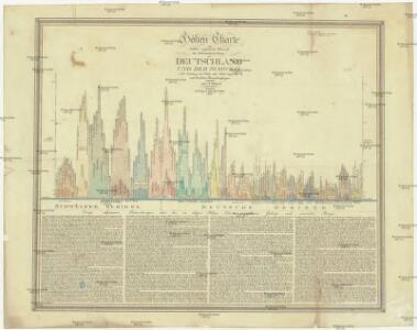
Höhen Charte oder bildlich vergleichende Uebersicht der bedeutendesten Berge in Deutschland und der Schweiz
1 : 22000 Německo Weiland, Karl Ferdinand Geograph. Institut
Bibliopolische Karte von Süddeutschland
Frankfurt nad Mohanem (Německo)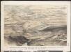
Stannard & Son's, panoramic birds-eye view of the French & Prussian provinces, on the banks of the Rhine, shewing all the fortresses belonging to each army, with the railways & frontier boundaries of each country
1 : 1
Karte der Eisenbahnen Deutschlands
1 : 700000 Südwest-Blatt Stich, Druck u. Verlag des lithographischen Instituts von Aug. Wehrt
195. Karwendel, uit: Topographische Uebersichtskarte des Deutschen Reiches / herausgegeben v. d. Kartogr. Abt. d. Königl. Preuß. Landesaufnahme
1 : 200000 titelvariant: Topogr. Übersichtskarte des Deutschen Reiches; Annotatie: Titel boven bladen ook: Topogr. Übersichtskarte des Deutschen Reiches; Annotatie geografische gegevens: Op elk blad twee maatstokken: 10 Kilometer = 5,5 cm; 1 geogr. Meile = 3,6 cm; Legenda onder op elk blad Königlich Preußische Landesaufnahme. Kartographische Abtheilung [S.l : Königlich Preußische Landesaufnahme, Kartographische Abtheilung]
Westdeutsches Mittelgebirge
Plastischer Schul-Atlas über alle Theile der Erde : in 24 Karten Woldermann, G Verlag von P. Eckerlein

Schematische Uebersichts - Skizze No,1 Feldzug 1796 in Süd - Deutschland

Germany. Deutschland III.
1 : 1760000 Society for the Diffusion of Useful Knowledge (Great Britain)

Carte des principaux points du théatre de la guerre présente sur le frontieres d'Allemagne et de Pays-Bas
1 : 2200000 Francie Bouge, Jean-Baptiste de chez J. B. de Bouge
Empire of Germany (southern portion).
1 : 1050000 Johnston, W. & A.K.
Sudwestliches Deutschland
1 : 1850000 Stieler, Adolf
Südwestliches Deutschland, enth. Bayern, Würtemberg, Baden, Hohenzollern und Schweiz
Hand-Atlas über alle Theile der Erde nach dem neuesten Zustande und über das Weltgebäude Stieler, Adolf bei Justus Perthes
Südwestliches Deutschland, enth. Bayern, Würtemberg, Baden, Hohenzollern und Schweiz
Hand-Atlas über alle Theile der Erde nach dem neuesten Zustande und über das Weltgebäude Stieler, Adolf bei Justus Perthes
[Das Deutsches Reich, Blatt 3]
Adolf Stieler's Handatlas über alle Theile der Erde und über das Weltgebäude Stieler, Adolf Justus Perthes
German Empire 3.
1 : 1774080 Letts, Son & Co.
Blatt 97: Metzingen, uit: Topographische Karte von Württemberg im Massstab 1:25.000 / hrsg. vom Statistischen Landesamt
1 : 25000 titelvariant: Topographische Karte des Königreichs Württemberg im Massstabe 1:25.000; Annotatie: Titelvariant: Topographische Karte des Königreichs Württemberg im Massstabe 1:25.000; Incompleet (4 bl. aanwezig) Württembergisches Statistisches Landesamt [Stuttgart : Statistisches Landesamt]
[Südwestliches Deutschland und Schweiz]
Stieler's Hand-Atlas Stieler, Adolf bei Justus Perthes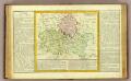
Bas Rhin, Franconie, Haut Rhin
1 : 1400000 Clouet, J. B. L. (Jean-Baptiste Louis), b. 1730
Germany No.4.
1 : 1375000 Colton, G.W.
Germany (Deutschland)
1 : 1750000 Bavorsko (Německo) Baldwin & Cradock
Souabe, Baviere.
1 : 2900000 Clouet, J. B. L. (Jean-Baptiste Louis), b. 1730
Western Germany 22
1 : 1700000 Appleton, D. & Co.
Süddeutschland

Süddeutchland

Jiho-západní Německo a Šwejcary
1 : 3300000 Německo jihozápadní Merklas, Václav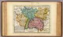
The south west part of Germany.
1 : 2400000 Moll, Herman, d. 1732
W. Germany.
1 : 1300000 Arrowsmith, John