Maps of Bavaria

Südwestliches Deutschland und Schweiz
Schul-Atlas über alle Theile der Erde nach dem neuesten Zustande, und über das Weltgebäude Stieler, Adolf bei Justus Perthes
Süd-Westliches Deutschland und die Schweiz
Hand-Atlas über alle Theile der Erde und über das Weltgebäude Stieler, Adolf Justus Perthes
Süd-Westliches Deutschland und die Schweiz
Handatlas über alle Theile der Erde und über das Weltgebäude Stieler, Adolf Justus Perthes
Sud-Westliches Deutschland Und Die Schweiz.
1 : 1850000 Vogel, C.
Südwestliches Deutschland, enth. Bayern, Würtemberg, Baden, Hohenzollern und Schweiz
Hand-Atlas über alle Theile der Erde nach dem neuesten Zustande und über das Weltgebäude Stieler, Adolf bei Justus Perthes
Südwestliches Deutschland, enth. Bayern, Würtemberg, Baden, Hohenzollern und Schweiz
Hand-Atlas über alle Theile der Erde nach dem neuesten Zustande und über das Weltgebäude Stieler, Adolf bei Justus Perthes
[Südwestliches Deutschland und Schweiz]
Stieler's Hand-Atlas Stieler, Adolf bei Justus Perthes
Sudwestliches Deutschland
1 : 1850000 Stieler, Adolf

German Empire 3.
1 : 1774080 Letts, Son & Co.
Bibliopolische Karte von Süddeutschland
Frankfurt nad Mohanem (Německo)
Germany. Deutschland III.
1 : 1760000 Society for the Diffusion of Useful Knowledge (Great Britain)
Jiho-západní Německo a Šwejcary
1 : 3300000 Německo jihozápadní Merklas, Václav
Carta noua accurata del paßagio et strada dalli Paesi Baßi per via de Allemagna per Italia et per via di paesi Suizeri a Geneua, Lione et Roma per seruizio delli marchanti et viagianti in gen.ale ad instanza delli Ss. scherer et di Momforti speditori delli marchantie in Bregens
1 : 2060000 Itálie Wit, Frederik de Frederico de Wit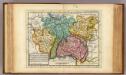
The south west part of Germany.
1 : 2400000 Moll, Herman, d. 1732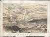
Stannard & Son's, panoramic birds-eye view of the French & Prussian provinces, on the banks of the Rhine, shewing all the fortresses belonging to each army, with the railways & frontier boundaries of each country
1 : 1
Germany (Deutschland)
1 : 1750000 Bavorsko (Německo) Baldwin & Cradock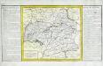
Cercle de Souabe
1 Karte : Kupferdruck ; 29 x 32 cm, Bildgrösse 31 x 55 cm Clouet Mondhare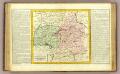
Souabe, Baviere.
1 : 2900000 Clouet, J. B. L. (Jean-Baptiste Louis), b. 1730
Raetiae veteris exterae et hodiernae una cum regionibus ei guondam [i.e. quondam] adnumeratis & finitimarum regionum limitibus tabula generalis
1 : 1100000 1 Karte Matth. Hirtzg. ; Leo. Scherer [Joh. Rodolff Wolffen], [Zürich]
[Schweiz]
1 : 2100000 1 Karte [von Johann Gerhard Reinhard Andreae] [bei Joh. Caspar Füessli Sohn, und in Commission bei Heinrich Steiner und Comp. Buchhändlern], [Winterthur]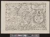
Provinciae Helveticae imago
1 : 1500000 1 Karte [neu bearb. von Giovanni Battista de Cassini] ; F.M.A.C. Dionantensis sculpsit [Ambrosius Ramellatus], [Mailand]

[Das Deutsches Reich, Blatt 3]
Adolf Stieler's Handatlas über alle Theile der Erde und über das Weltgebäude Stieler, Adolf Justus Perthes
Süddeutschland
Volksschul-Atlas über alle Teile der Erde Lange, Henry Druck und Verlag von Georg Westermann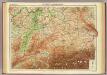
Germany - southern section.
1 : 1000000 John Bartholomew and Son
Suisse
1 : 3500000 1 Karte [Alain Manesson Mallet] [in verlegung Johann David Zunners], [Franckfurt am Mayn]
Karte der Eisenbahnen Deutschlands
1 : 700000 Südwest-Blatt Stich, Druck u. Verlag des lithographischen Instituts von Aug. Wehrt
Haupt-Dreiecknetz für das Königreich Bayern
1 : 1000000 Stiglmayer Contur Obernetter Schrift [gravirt] [S.l.] : [s.n.]


