Maps of Switzerland

[Schweiz]
1 : 2100000 1 Karte [von Johann Gerhard Reinhard Andreae] [bei Joh. Caspar Füessli Sohn, und in Commission bei Heinrich Steiner und Comp. Buchhändlern], [Winterthur]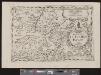
Provinciae Helveticae imago
1 : 1500000 1 Karte [neu bearb. von Giovanni Battista de Cassini] ; F.M.A.C. Dionantensis sculpsit [Ambrosius Ramellatus], [Mailand]
Südwestliches Deutschland und Schweiz
Schul-Atlas über alle Theile der Erde nach dem neuesten Zustande, und über das Weltgebäude Stieler, Adolf bei Justus Perthes
Süd-Westliches Deutschland und die Schweiz
Hand-Atlas über alle Theile der Erde und über das Weltgebäude Stieler, Adolf Justus Perthes
Süd-Westliches Deutschland und die Schweiz
Handatlas über alle Theile der Erde und über das Weltgebäude Stieler, Adolf Justus Perthes
Jiho-západní Německo a Šwejcary
1 : 3300000 Německo jihozápadní Merklas, Václav
Südwestliches Deutschland, enth. Bayern, Würtemberg, Baden, Hohenzollern und Schweiz
Hand-Atlas über alle Theile der Erde nach dem neuesten Zustande und über das Weltgebäude Stieler, Adolf bei Justus Perthes
Suisse
1 : 3500000 1 Karte [Alain Manesson Mallet] [in verlegung Johann David Zunners], [Franckfurt am Mayn]
[Südwestliches Deutschland und Schweiz]
Stieler's Hand-Atlas Stieler, Adolf bei Justus Perthes
Armoiries des XIII cantons et des alliés
1 : 2500000 1 Karte [Chenebié], [Vevey]
<<Les>> 13 cantons suisses et leurs alliéz
1 : 3500000 1 Karte [Alain Manesson Mallet] [chez Denys Thierry?], [Paris]
German Empire 3.
1 : 1774080 Letts, Son & Co.
Sudwestliches Deutschland
1 : 1850000 Stieler, Adolf
Karte von Deutschland in IV Blättern
1 : 825000 Südwest-Blatt Sotzmann, Daniel Friedrich im Verlage der A. G. Schneider und Weigels
Südwestliches Deutschland, enth. Bayern, Würtemberg, Baden, Hohenzollern und Schweiz
Hand-Atlas über alle Theile der Erde nach dem neuesten Zustande und über das Weltgebäude Stieler, Adolf bei Justus Perthes
Sud-Westliches Deutschland Und Die Schweiz.
1 : 1850000 Vogel, C.
Assemblage de l' atlas Suisse.
From Atlas Suisse. Levé et dessiné par J. H. Weiss aux fraix de J. R. Meyer á Aarau dans les années 1786 á 1802. Gravée par Guerin, Eichler, et Scheurmann.

Germany. Deutschland III.
1 : 1760000 Society for the Diffusion of Useful Knowledge (Great Britain)
Topographische Karte der Schweiz (Dufour-Karte): Den Kanton Zürich betreffende Blätter: Blatt XXI: Bonneville, Sallenches; Übersicht der Blätter
1 : 100000 Leitung: Dufour, Guillaume-Henri (1787-1875), General, Politiker, Ingenieur und Kartograf, von Genf; Eidgenössisches Topographisches Bureau, in Genf Stich: Bachofen, Johann Heinrich, andere Schreibweise: Jean-Henri, (1821-1889), Zeichner, Maler, Architekt und Topograf, von Uster; Bressanini, Rinaldo (1803-1864), Kupferstecher und Kartograf, von Italien
Germany (Deutschland)
1 : 1750000 Bavorsko (Německo) Baldwin & Cradock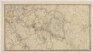
Karte der Eisenbahnen Deutschlands
1 : 700000 Südwest-Blatt Stich, Druck u. Verlag des lithographischen Instituts von Aug. Wehrt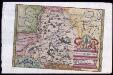
Provincia Helvetiae
Johannes a Montecalerio
Carte du comté de Tirol et des possessions de la maison d'Autriche dans le cercle de Souabe
1 : 1380000 Rakousko (1526-1804) Mentelle, Edme Tardieu, Pierre François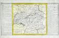
Cercle de Souabe
1 Karte : Kupferdruck ; 29 x 32 cm, Bildgrösse 31 x 55 cm Clouet Mondhare
Sud-Ostliches Deutschland nebst einem Theile des nordlichen, Italien.
1 : 1850000 Berghaus, Hermann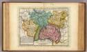
The south west part of Germany.
1 : 2400000 Moll, Herman, d. 1732
Raetiae veteris exterae et hodiernae una cum regionibus ei guondam [i.e. quondam] adnumeratis & finitimarum regionum limitibus tabula generalis
1 : 1100000 1 Karte Matth. Hirtzg. ; Leo. Scherer [Joh. Rodolff Wolffen], [Zürich]
Elvezia, o, Paese de'Svizzeri
1 : 1500000 1 Karte Giovanni di Pietro incise [Batelli e Fanfani], [Milano]
![[Schweiz]](https://images-2.georeferencer.com/images/iiif/948163738739/full/,300/0/native.jpg)

