Maps of Switzerland

Suisse
1 : 3500000 1 Karte [Alain Manesson Mallet] [in verlegung Johann David Zunners], [Franckfurt am Mayn]
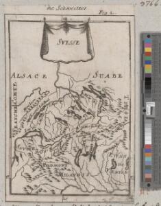
<<Les>> 13 cantons suisses et leurs alliéz
1 : 3500000 1 Karte [Alain Manesson Mallet] [chez Denys Thierry?], [Paris]
Armoiries des XIII cantons et des alliés
1 : 2500000 1 Karte [Chenebié], [Vevey]
[Helvetien]
1 : 3100000 1 Karte entworfen von F.L. Güssefeld ; gestochen von J.C. Müller [im Verlage des Industrie Comptoirs], [Weimar]
Assemblage de l' atlas Suisse.
From Atlas Suisse. Levé et dessiné par J. H. Weiss aux fraix de J. R. Meyer á Aarau dans les années 1786 á 1802. Gravée par Guerin, Eichler, et Scheurmann.
Helvetiae descriptio
1 Karte Aegidio Tschudo auct. ; [Abraham Ortelius fecit] [en la emprenta de Roberto Bruneau?], [Anveres]
Erste Post- & Dampfschifffahrt Reise Carte der Schweiz
1 : 750000 1 Karte entworfen, bearb. und einer hochloblichen Post-Commission der Stadt Basel ergebenst gewidmet von Hiers. Rumpf ; auf Stein gestochen von C. Bruder E. Hindermann's Witwe, Basel
Karte von Deutschland in IV Blättern
1 : 825000 Südwest-Blatt Sotzmann, Daniel Friedrich im Verlage der A. G. Schneider und Weigels
<<Les>> Suisses, les alliés des Suisses et leurs sujets
1 Karte par N. Sanson d'Abbeville ; R. Cordier sculp. [Verlag nicht ermittelbar], [Erscheinungsort nicht ermittelbar]
Elvezia, o, Paese de'Svizzeri
1 : 1500000 1 Karte Giovanni di Pietro incise [Batelli e Fanfani], [Milano]
German Empire 3.
1 : 1774080 Letts, Son & Co.
Le Cours du Danube
1 : 1800000 Mollova mapová sbírka Placide de Sainte-Hélène Inselin, Charles
Suisse
1 : 3600000 1 Karte V. Levasseur ; gravé par: Laguillermie [Bureaux du Journal des connaissances utiles], [Paris]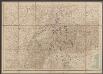
Uebersichtskarte der Schweiz mit ihren Grenzgebieten
1 : 1000000 Leuzinger, Rudolf ; Hoven, Georg Christian von Eidg. Stabsbureau
[Schweiz]
1 : 2100000 1 Karte [von Johann Gerhard Reinhard Andreae] [bei Joh. Caspar Füessli Sohn, und in Commission bei Heinrich Steiner und Comp. Buchhändlern], [Winterthur]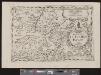
Provinciae Helveticae imago
1 : 1500000 1 Karte [neu bearb. von Giovanni Battista de Cassini] ; F.M.A.C. Dionantensis sculpsit [Ambrosius Ramellatus], [Mailand]
General-Carte der Schweiz
1 : 1200000 1 Karte entworfen und gestochen von J. Scheurmann bey Orell Füssli & Compagnie, Zürich
Uebersichtskarte der Schweiz mit ihren Grenzgebieten
1 : 1000000 Leuzinger, Rudolf Eidg. Stabsbureau
Uebersichtskarte der Schweiz mit ihren Grenzgebieten / gez. u. gest. von R. Leuzinger ; Schrift C. v. Hoven
1 : 1000000 titelvariant: Uebersichtskarte der Schweiz; Annotatie: Oorspr. uitg.: [S.l.] : Eidg. topogr. Bureau, 1878 R. Leuzinger; C. v. Hoven [S.l. : s.n.] / (Bern : Kümmerly & Frey)
Suisse, or, Switzerland with their allies and subjects &c
1 : 1350000 1 Karte by H. Moll [printed for Thomas and John Bowles?], [London]
Topographische Karte der Schweiz (Dufour-Karte): Den Kanton Zürich betreffende Blätter: Blatt XXI: Bonneville, Sallenches; Übersicht der Blätter
1 : 100000 Leitung: Dufour, Guillaume-Henri (1787-1875), General, Politiker, Ingenieur und Kartograf, von Genf; Eidgenössisches Topographisches Bureau, in Genf Stich: Bachofen, Johann Heinrich, andere Schreibweise: Jean-Henri, (1821-1889), Zeichner, Maler, Architekt und Topograf, von Uster; Bressanini, Rinaldo (1803-1864), Kupferstecher und Kartograf, von Italien
Helvetia
1 : 4200000 1 Karte Aegidio Tschudo auctore [Compagnia Bresciana], [Brescia]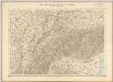
Uebersichtskarte der Schweiz mit ihren Grenzgebieten / gez. u. gest. von R. Leuzinger ; Schrift C. v. Hoven
1 : 1000000 titelvariant: Uebersichtskarte der Schweiz; Annotatie: Oorspr. uitg.: [S.l.] : Eidg. Stadsbureau, 1878 R. Leuzinger; C. v. Hoven [S.l. : s.n.]
<<A>> new & accurate map of Switzerland with its allies and subjects
1 : 1700000 1 Karte composed from ey. most approv'd maps &c and regulated by astronom. observat. by Emanl. Bowen [printed for William Innys ...], [London]
Carte de Suisse suivant sa nouvelle division en XVIII cantons formant la république helvétique
1 Karte in 2 Teilen auf 1 Bl. dressée par H. Mallet ; Emery sc. [chez F. Monty], [Genève]
<<La>> Suisse
1 : 5000000 1 Karte [von S.L. Hegrad] [bey Sebastian Hartl in der Singerstrasse], [Wien]
[Helvetia]
1 : 700000 1 Karte auf 2 Bl. Paulus de Forlanis [Forlani], Venetij
Helvetia, Eydtgnossschafft, oder Schweytzerlandt, mit dero Gräntzen
1 Karte formis Davidis Hautii, Lucerne Helvet.
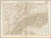
Südwestliches Deutschland und Schweiz
Schul-Atlas über alle Theile der Erde nach dem neuesten Zustande, und über das Weltgebäude Stieler, Adolf bei Justus Perthes