Maps of Bavaria

Sudwestliches Deutschland
1 : 1850000 Stieler, Adolf

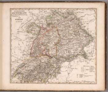
Südwestliches Deutschland, enth. Bayern, Würtemberg, Baden, Hohenzollern und Schweiz
Hand-Atlas über alle Theile der Erde nach dem neuesten Zustande und über das Weltgebäude Stieler, Adolf bei Justus Perthes
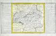
[Südwestliches Deutschland und Schweiz]
Stieler's Hand-Atlas Stieler, Adolf bei Justus Perthes
Südwestliches Deutschland, enth. Bayern, Würtemberg, Baden, Hohenzollern und Schweiz
Hand-Atlas über alle Theile der Erde nach dem neuesten Zustande und über das Weltgebäude Stieler, Adolf bei Justus Perthes
Sud-Westliches Deutschland Und Die Schweiz.
1 : 1850000 Vogel, C.
Süd-Westliches Deutschland und die Schweiz
Handatlas über alle Theile der Erde und über das Weltgebäude Stieler, Adolf Justus Perthes
Süd-Westliches Deutschland und die Schweiz
Hand-Atlas über alle Theile der Erde und über das Weltgebäude Stieler, Adolf Justus Perthes
Südwestliches Deutschland und Schweiz
Schul-Atlas über alle Theile der Erde nach dem neuesten Zustande, und über das Weltgebäude Stieler, Adolf bei Justus Perthes
German Empire 3.
1 : 1774080 Letts, Son & Co.
Germany. Deutschland III.
1 : 1760000 Society for the Diffusion of Useful Knowledge (Great Britain)
Jiho-západní Německo a Šwejcary
1 : 3300000 Německo jihozápadní Merklas, Václav
Bibliopolische Karte von Süddeutschland
Frankfurt nad Mohanem (Německo)
Cercle de Souabe
1 Karte : Kupferdruck ; 29 x 32 cm, Bildgrösse 31 x 55 cm Clouet Mondhare
Souabe, Baviere.
1 : 2900000 Clouet, J. B. L. (Jean-Baptiste Louis), b. 1730
Germany (Deutschland)
1 : 1750000 Bavorsko (Německo) Baldwin & Cradock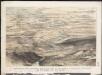
Stannard & Son's, panoramic birds-eye view of the French & Prussian provinces, on the banks of the Rhine, shewing all the fortresses belonging to each army, with the railways & frontier boundaries of each country
1 : 1
[Das Deutsches Reich, Blatt 3]
Adolf Stieler's Handatlas über alle Theile der Erde und über das Weltgebäude Stieler, Adolf Justus Perthes
Süddeutschland
Volksschul-Atlas über alle Teile der Erde Lange, Henry Druck und Verlag von Georg Westermann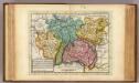
The south west part of Germany.
1 : 2400000 Moll, Herman, d. 1732
Haupt-Dreiecknetz für das Königreich Bayern
1 : 1000000 Stiglmayer Contur Obernetter Schrift [gravirt] [S.l.] : [s.n.]
Raetiae veteris exterae et hodiernae una cum regionibus ei guondam [i.e. quondam] adnumeratis & finitimarum regionum limitibus tabula generalis
1 : 1100000 1 Karte Matth. Hirtzg. ; Leo. Scherer [Joh. Rodolff Wolffen], [Zürich]
Composite I, II, VI, VII: Karte Des Oesterreichischen Kaiserstaates.
1 : 576000 Scheda, Josef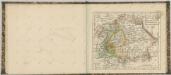

Baden, Würtemberg, Baiern
Schul-Atlas in 36 Karten Völter, Daniel Verlag der J.M. Dannheimer'schen Buchhandlung
Plan qui réuni les duchés de Julier, et de Berg, le palatinat du Rhin, les duchés de Baviere et de Neubourg, sans y comprendre le marquisat de Berg op Zoom
1 : 1250000 par son très humble, très soumis, et très obeisant serviteur De St. Michel, Ingenieur A Augsbourg : publié par les freres Lotter
[Schweiz]
1 : 2100000 1 Karte [von Johann Gerhard Reinhard Andreae] [bei Joh. Caspar Füessli Sohn, und in Commission bei Heinrich Steiner und Comp. Buchhändlern], [Winterthur]
Suevia Et Bavaria XI. Nova Tabula. [Karte], in: Claud. Ptolemaeus. Geographia lat. cum mappis [...], S. 380.
1 Karte aus Atlas Münster, Sebastian [und Ptolemaeus, Claudius]