Maps of Germany

Nova Germaniae
1 : 3420000 Belgie
Carte Generale des Etats composant La Confederation Germanique.
1 : 2750000 Vivien de St Martin, L.
195. Karwendel, uit: Topographische Uebersichtskarte des Deutschen Reiches / herausgegeben v. d. Kartogr. Abt. d. Königl. Preuß. Landesaufnahme
1 : 200000 titelvariant: Topogr. Übersichtskarte des Deutschen Reiches; Annotatie: Titel boven bladen ook: Topogr. Übersichtskarte des Deutschen Reiches; Annotatie geografische gegevens: Op elk blad twee maatstokken: 10 Kilometer = 5,5 cm; 1 geogr. Meile = 3,6 cm; Legenda onder op elk blad Königlich Preußische Landesaufnahme. Kartographische Abtheilung [S.l : Königlich Preußische Landesaufnahme, Kartographische Abtheilung]
West-Duitschland
1 : 840000 Annotatie: Notities in zwart en rood potlood met betrekking tot geallieerde troepenbewegingen eind 1944, begin 1945 [S.l] : [s.n]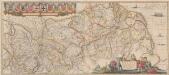
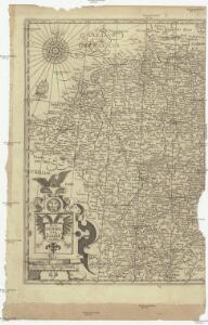
Rhenus Fluviorum Europae celeberrimus, cum Mosa, Mosella, et reliquis, in illum se exonerantibus fluminibus. [Karte], in: Novus atlas absolutissimus, Bd. 2, S. 145.
1 Karte aus Atlas Janssonius Offizin
Rhenus Fluviorum Europae celeberrimus, cum Mosa, Mosella, et reliquis, in illum se exonerantibus fluminibus. [Karte], in: Gerardi Mercatoris et I. Hondii Newer Atlas, oder, Grosses Weltbuch, Bd. 1, S. 203.
1 Karte aus Atlas Mercator, Gerhard und Hondius, Jodocus Jansson, Jan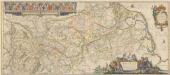
Rhenus Fluviorum Europae celeberrimus, cum Mosa, Mosella, et reliquis, in illum se exonerantibus, fluminibus. [Karte], in: Novus Atlas, das ist, Weltbeschreibung, Bd. 1, S. 240.
1 Karte aus Atlas Blaeu, Joan Blaeu, Willem Janszoon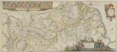
Rhenus Fluviorum Europae celeberrimus, cum Mosa, Mosella, et reliquis, in illum se exonerantibus, fluminibus. [Karte], in: Theatrum orbis terrarum, sive, Atlas novus, Bd. 1, S. 305.
1 Karte aus Atlas Blaeu, Joan Blaeu, Willem Janszoon
Rhenus Fluviorum Europae celeberrimus, cum Mosa, Mosella, et reliquis, in illum se exonerantibus, fluminibus. [Karte], in: Le théâtre du monde, ou, Nouvel atlas contenant les chartes et descriptions de tous les païs de la terre, Bd. 1, S. 269.
1 Karte aus Atlas Blaeu, Willem Janszoon und Blaeu, Joan Blaeu, Willem Janszoon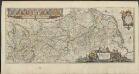
RHENVS | Fluviorum Europæ celeberrimus, | cum MOSA, MOSELLA, et | reliquis, in illum se exonerantibus, | fluminibus.
[Amsterdam : Joan Blaeu]
Le Cours De La Riviere Du Rhein depuis sa Source jusques a son Emboucheure [...] [Karte], in: Atlas nouveau, contenant toutes les parties du monde [...], Bd. 1, S. 166.
1 Karte aus Atlas Sanson, Nicolas Jaillot, Alexis Hubert und Mortier, Pieter
Germany.
1 : 3651000 Fisher, Richard Swainson
Demarcations-Linie welche Kraft dem am 17. May 1795 zwischen Frankreich und Preussen geschlossenen Vergleich bestimmt : wie weit die Franzosen disseits des Rheins in Deutschland vordringen dürffen
1 : 1300000 Augsburg : Johann Walch
Tabula geographica qua pars septentrionalis sive Inferior Rheni, Mosae, et Mosellae, maximaeque partes Visurgis, Moeni, Amasi, Scaldis, Isalae, et alia in eosdem inluentia flumina, nec non provinciae Germaniae inferioris, Westphaliae, Hassiae, archiepiscopatus et electoratus Coloniensis ac Trevirensis, cum partibus Moguntini, et Palatinus Rheni, et aliae regiones adjacentes
1 : 1000000 accuratissime ostenduntur per Nicolaum Visscher Amst. Bat. Amst[elodami] Bat[avorum] : nunc apud Petrum Schenk Jun.
Le Cours de la Riviere du Rhein
1 : 1100000 Mollova mapová sbírka Jaillot, Alexis-Hubert Chauveau, François Jaillot, Alexis Hubert
Westfront
1 : 1100000 [S.l. : s.n.]
Germany-Czechoslovakia-Poland
Germany-Czechoslovakia-Poland [Aerodromes, Landing grounds, Seaplane bases], ADI (Maps) AM 8058A. [S.l.] : Air Ministry, United Kingdom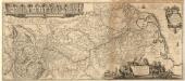
Rhenvs Fluviorum Europae celeberrimus, cum Mosa, Mosella, et reliquis in illum se exonerantibus, fluminibus
1 : 1600000 Mollova mapová sbírka Blaeu, Willem Janszoon Blaeu, Willem Jansz.
Carta noua accurata del paßagio et strada dalli Paesi Baßi per via de Allemagna per Italia et per via di paesi Suizeri a Geneua, Lione et Roma per seruizio delli marchanti et viagianti in gen.ale ad instanza delli Ss. scherer et di Momforti speditori delli marchantie in Bregens
1 : 2060000 Itálie Wit, Frederik de Frederico de Wit
Bibliopolische Karte von Süddeutschland
Frankfurt nad Mohanem (Německo)
Karte der Eisenbahnen Deutschlands
1 : 700000 Südwest-Blatt Stich, Druck u. Verlag des lithographischen Instituts von Aug. Wehrt
Totius Rheni tractus
1 : 870000 Mollova mapová sbírka Valk, Gerhard Valck, Gerard
Charte von Deutschland zu dem Meilen-Zeiger
1 : 222000 Německo Schreiber, Johann Georg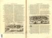
Germania Parte Occidentale
1 : 2100000 Mollova mapová sbírka Coronelli, Vincenzo Maria
Germania Parte Occidentale
1 : 2100000 Mollova mapová sbírka Coronelli, Vincenzo Maria
Le Theatre de Bellone :
Mollova mapová sbírka Schenk, Pieter Braakman, Adriaan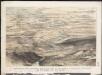
Stannard & Son's, panoramic birds-eye view of the French & Prussian provinces, on the banks of the Rhine, shewing all the fortresses belonging to each army, with the railways & frontier boundaries of each country
1 : 1
Etats Secondaires de L'Allemagne.
Andriveau-Goujon, J.
Germany, W. sheet.
1 : 1400000 Rand McNally and Company