Maps of Grand Est

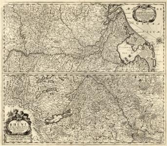
Totius Rheni ab ejus capitibus ad Oceanum usque Germanicum in quem se exonerat Novißima Descriptio
1 : 810000 Mollova mapová sbírka Janssonius, Johannes Janssonius, Johannes I
Carte des principaux points du théatre de la guerre présente sur le frontieres d'Allemagne et de Pays-Bas
1 : 2200000 Francie Bouge, Jean-Baptiste de chez J. B. de Bouge
Kriegs-Karte 1870
1 : 1000000 Belgie Eduard Hallberger
France.
1 : 4400000 Vivien de St Martin, L.
Kriegs - Karte 1870

Belli ab obitu Caroli VI. Imperatoris usqve ad pacem Dresdae d. 25. Dec. MDCCXLV
1 : 1300000 Mollova mapová sbírka Kraus, Lorenz Jacob Homann, Johann Baptista - dědici
Bibliopolische Karte von Süddeutschland
Frankfurt nad Mohanem (Německo)
[Frankreich, Blatt 2]
Adolf Stieler's Handatlas über alle Theile der Erde und über das Weltgebäude Stieler, Adolf Justus Perthes
Carte de la France, 2
2 Blätter : mehrfarbig ; 71 x 83 cm de Belleyme
Territory in Western Germany occupied by the Allied Armies
1 : 1000000 First World War map of the territory in Western Germany occupied by the Allied Armies and the stages of evacuation according to article 429 of the peace treaty. Situation for July 1921. War Office
SW pt. of Germany.
1 : 2300000 Bowen, Emanuel
Frankreich. Upper right sheet
1 : 1200000 Geographisches Institut (Weimar, Germany)
Carte de la France, 2
1 Blatt : 61 x 83 cm de Belleyme
Neue vollkomene Landkarten des h. Röm. Reichs, Ober und Nieder Rheinisch- Fränkisch- Schwäbisch- und theils Bayrischen Kraises, samt denenselber angelegner Orten, an einem und dann Anderntheils, derer dem röm. Reich, durch Franckreich in dem vergangen und noch lauffenden Seculo entzogenen Ländern, Elsaß, Lothring, Burgund, Metz, Toul, Verdun, nicht weniger denen neu gemachten dependentien mit Anmerkung aller vornehmer Ort und Vöstungen, vornemlich am Rhein-Strom, von Basell, bis unterhalb Cölln etc. etc
1 : 1100000 Alsasko (Francie) Endter, Martin Martin Endter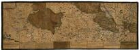
Rhenus Bicornis hoc est Totius Rheni tractus delineatio
Mollova mapová sbírka Vopel, Caspar Tscherning, Johann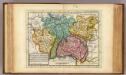
The south west part of Germany.
1 : 2400000 Moll, Herman, d. 1732
Neue Vollkomene Landkarten. Des Röm: Reichs Ober und Nider Rheinisch-Fränkisch-Schwäbisch- und theils Bayrischen Kraises, samt denenselber etc angelegner Orten an einem Und dann Anderntheils, derer dem Röm: Reich, durch Franckreich in dem vergangen und noch laufenden Seculo entzogenen Ländern, Elsaß, Lothring, Burgund, Metz, Toul, Verdün
Mollova mapová sbírka
Neueste und aceurate Landkarte des volligen-Rheinstroms mit den daran gelegenen Landschafften und benachbarten Provinzien, auch einem grossen theil des Franzos: Konigreiches
Mollova mapová sbírka Lerch, Johann Martin Lerch, Johann Martin
West-Duitschland
1 : 840000 Annotatie: Notities in zwart en rood potlood met betrekking tot geallieerde troepenbewegingen eind 1944, begin 1945 [S.l] : [s.n]
Sedes ac Theatrvm Bellorvm per plurimos annos in Regionibus Rheni, Mosae ac Mosellae adjacentibus
Lotter, Tobias Conrad; Bodenehr, Gabriel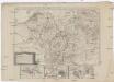
Neue Karte von den gegenwärtigen Französischen Kriegs - Schauplatze, welche die Länder am Ober und nieder Rhein, Elßas, Lothringen, die Nieder-Pfaltz, Maynz, Trier, Cöln, dei Österreichische Niederlandes, ein Theil von Frankreich, Westphalen, Heßsen und Schwaben etc
1 : 1400000 Alsasko (Francie)
Karte der Eisenbahnen Deutschlands
1 : 700000 Südwest-Blatt Stich, Druck u. Verlag des lithographischen Instituts von Aug. Wehrt
Carte de la République française, 2
1 Blatt : 42 x 51 cm P.G. Chanlaire

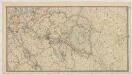
Tabula geographica qua pars septentrionalis sive Inferior Rheni, Mosae, et Mosellae, maximaeque partes Visurgis, Moeni, Amasi, Scaldis, Isalae, et alia in eosdem inluentia flumina, nec non provinciae Germaniae inferioris, Westphaliae, Hassiae, archiepiscopatus et electoratus Coloniensis ac Trevirensis, cum partibus Moguntini, et Palatinus Rheni, et aliae regiones adjacentes
1 : 1000000 accuratissime ostenduntur per Nicolaum Visscher Amst. Bat. Amst[elodami] Bat[avorum] : nunc apud Petrum Schenk Jun.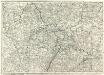
Carte Generale d'Allemagne
1 : 1300000 Mollova mapová sbírka Eisenschmidt, Johann Caspar Julien, Roch Joseph
Frankreich In 4 Blattern, Blatt 2.
1 : 1500000 Vogel, C.
[Das Deutsches Reich, Blatt 3]
Adolf Stieler's Handatlas über alle Theile der Erde und über das Weltgebäude Stieler, Adolf Justus Perthes