Maps of Normandy

Der Canal mit den Englischen und Französischen Küsten
Geologischer Atlas zur Naturgeschichte der Erde Leonhard, Carl Cäsar von E. Schweizerbart'sche Verlagsbuchhandlung
Cartes et coupe du Canal de la Manche et d'une partie de la mer d'Allemagne qui présentent par une nouvelle méthode la pente du fonds de ces deux mers
1 Karte : Kupferdruck ; 16 x 23 cm, Blattgrösse 46 x 61 cm Buache Philippe Buache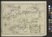
A Chart of the English Channel with the adjacent coasts of England and France.
from Atlantic Ocean
43 Sheet A, uit: France (North West), Belgium (West and Central), Holland (part of) ; France (South West), Spain (North)
1 : 1000000 [London : MI9]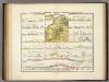
Geologische Profile von Deutschland im Allgemeinen.
1 : 3870000 Berghaus, Heinrich
Carte du Canal ou de la Manche, 2
1 Blatt : 74 x 52 cm Esnauts et Rapilly
The seat of war in France, showing the scene of M'Mahon's defeat and capitulation, Paris and its environs, and its railroad connections with Tours, Cherbourg, Havre and other cities
1 : 1
[Geologische Profile von Deutschland im Allgemeinen u. vom Riesengebirge im besondern]
Erster Band, enthaltend in vier Abtheilungen die Erscheinungen der anorganischen Natur: 1. Meteorologie und Klimatographie. 2. Hydrologie und Hydrographie. 3. Geologie. 4. Tellurischer Magnetismus Humboldt, Alexander von Verlag von Justus Perthes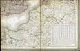
Carte des iles britanniques ou Royaume-Uni de la Grande Bretagne et d'Irlande, 6
2 Blätter : je 50 x 39 cm
Gallia Belgica et Germania Vtraqve Cisrhenana Svperior et Inferior excvsa
1 : 26000000 Mollova mapová sbírka Weigel, Christoph Weigel, Christoph I.
67-68. North-East France, Belgium, Luxemburg. The World Atlas.
1 : 1250000 USSR (Union of Soviet Socialist Republics).
Map of the Seat of War in France.
1 : 2600000 Carey, Mathew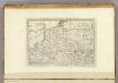
Map of the Seat of War in France, with the Country divided into its Several Departments.
1 : 2700000 Carey, Mathew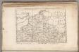
Map of the Seat of War in France, with the Country divided into its Several Departments.
1 : 2700000 Carey, Mathew
France Régionale Bassin de Paris Région du Nord carte physique
Gallois, Lucien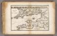
La Manche.
1 : 2100000 Vincent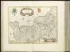
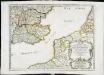
[16][16] Normandia Ducatus, uit: Atlas sive Descriptio terrarum orbis
Annotatie: Gedigitaliseerde versie. Amsterdam. Heiloo : Picturae (vervaardiger), 2015. tiff-bestand. Gedigitaliseerd: 07-01-2015; Origineel: Universiteitsbibliotheek Vrije Universiteit (XL.05127.-) ; Netherlands; Titelpagina ontbreekt Wit, Frederik de Amsterdam : Frederick de Wit
Théatre de la guerre, ou carte des frontières de la république française et de l'empire d'Allemagne, 1
1 Teil : Delamarche
Reliefkarte des Kanals von Cherbourg bis zur Scheldemündung
Anglie jihovýchodní Franckh'sche Verlagshandlung
Karte von Frankreich in XVI Blättern, No. 2 und [No. 6]
2 Blätter : 52 x 34 cm Königl. Preuss. Academischen Kunst und Buchhandlung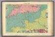
English Channel.
1 : 1500000 Philip, George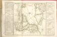
Reliefkarte des Kanals von Cherbourg bis zur Scheldemündung mit Südost - England und Nordfrankreich
Anciens royaumes de Kent, d'Essex, et de Sussex
1 Karte : Kupferdruck ; 36 x 47 cm Sanson chez l'auteur pres de S. Germain l'Auxerrois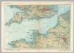
English Channel. Pergamon World Atlas.
1 : 1250000 Polish Army Topography Service

Région Nord comprenant les XI departements du Nord de la France
1 Karte : Kupferdruck ; 53 x 46 cm Lotter; Lotter Lotter
A map of the seat of war in France, with the country divided into its several departments
1 : 2600000
La Seine.
1 : 1400000 Buache, Philippe, 1700-1773


