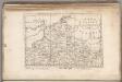
Maps of Normandy

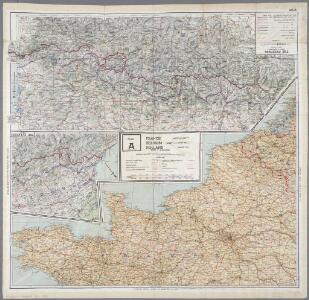
43 Sheet A, uit: France (North West), Belgium (West and Central), Holland (part of) ; France (South West), Spain (North)
1 : 1000000 [London : MI9]
A Chart of the English Channel with the adjacent coasts of England and France.
from Atlantic Ocean
Cartes et coupe du Canal de la Manche et d'une partie de la mer d'Allemagne qui présentent par une nouvelle méthode la pente du fonds de ces deux mers
1 Karte : Kupferdruck ; 16 x 23 cm, Blattgrösse 46 x 61 cm Buache Philippe Buache
La Manche.
1 : 4300000 Desmarest, Nicolas, 1725-1815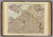
France N.
1 : 1750000 Andree, Richard; Times (London, England)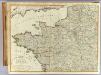
N.W. France.
1 : 1000000 Robert Laurie & James Whittle
La Manche
1 Karte : Kupferdruck ; 50 x 61 cm Jefferys; Le Rouge chez Le Rouge géographe du roi rue des g.ds Augustins
La Manche
1 Karte : Kupferdruck ; 50 x 61 cm Jefferys; Le Rouge chez Le Rouge géographe du roi rue des g.ds Augustins
Carte de la Manche
1 Karte : Kupferdruck ; 50 x 66 cm Lattré chéz Lattré graveur ordinaire du roi de M. le duc d'Orléans et de la ville rue St. Jacques la porte cochère en face de la rue de la Parcheminerie
Der Canal mit den Englischen und Französischen Küsten
Geologischer Atlas zur Naturgeschichte der Erde Leonhard, Carl Cäsar von E. Schweizerbart'sche Verlagsbuchhandlung
Canalis inter Angliæ et Galliæ littora
1 Karte : Kupferdruck ; 48 x 55 cm Renard gedruckt by L. Renard
La Manche, ou le Canal, entre la France et l'Angleterre
1 Karte : Kupferdruck ; 49 x 59 cm Jaillot; Goere H. Jaillot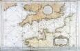
Carte reduite de la Manche
1 Karte : Kupferdruck ; 54 x 83 cm Bellin s.n.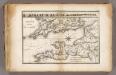
La Manche.
1 : 2100000 Vincent
Manica, gallis la Manche, et belgis het Canaal, pars oceani inter Angliam et Gallicam
1 Karte : Kupferdruck ; 46 x 55 cm Visscher; Gouwen Nicolaes Visscher
Carte De La Manche. [Karte], in: Atlas nouveau, contenant toutes les parties du monde [...], Bd. 1, S. 53.
1 Karte aus Atlas Sanson, Nicolas Jaillot, Alexis Hubert und Mortier, Pieter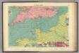
English Channel.
1 : 1500000 Philip, George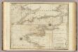
A chart of the British Channel.
1 : 1780000 Jefferys, Thomas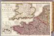
France 1.
1 : 1170000 Herisson, Eustache, b. 1759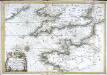
Carte de la Manche
1 Karte : Kupferdruck ; 47 x 68 cm Denis; Basset; Basset chés Basset rue St. Jacques au coin de celle des Mathurins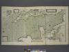
A new and correct draught of the CHANNELL between ENGLAND and FRANCE
from The sea-atlas : containing an hydrographical description of most of the sea-coasts of the known parts of the world.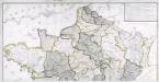
Carte générale des fleuves, des rivieres, et des principaux ruisseaux de la France, 1
1 Blatt : chez l'auteur Dupain-Triel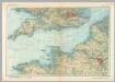
English Channel. Pergamon World Atlas.
1 : 1250000 Polish Army Topography Service
Carte du Canal ou de la Manche, 2
1 Blatt : 74 x 52 cm Esnauts et Rapilly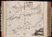
Pascaert van 't Canaal tusschen Engeland en Vranckryck
1 : 1150000 Annotatie: Oorspr. verschenen in: Zee atlas. - 't Amsterdam : by Jacobus Robyn, 1683; Origineel is Blad 25 in atlas factice [Amsterdam : gedruckt bij J. Robijn]
France I.
1 : 1800000 Society for the Diffusion of Useful Knowledge (Great Britain)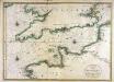
Carte de la Manche
1 Karte : Kupferdruck ; 56 x 79 cm Jaillot; Sanson chez Hubert Jaillot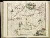
[130][133] Pascaert van 't Canaal tusschen Engeland en Vranckryck, uit: Atlas sive Descriptio terrarum orbis
Annotatie: Gedigitaliseerde versie. Amsterdam. Heiloo : Picturae (vervaardiger), 2015. tiff-bestand. Gedigitaliseerd: 07-01-2015; Origineel: Universiteitsbibliotheek Vrije Universiteit (XL.05127.-) ; Netherlands; Titelpagina ontbreekt Wit, Frederik de Amsterdam : Frederick de Wit
Carte de la France, 1
2 Blätter : mehrfarbig ; 72 x 81 cm de Belleyme
Map of the Seat of War in France.
1 : 2600000 Carey, Mathew
Map of the Seat of War in France, with the Country divided into its Several Departments.
1 : 2700000 Carey, Mathew