Maps of England

La Manche.
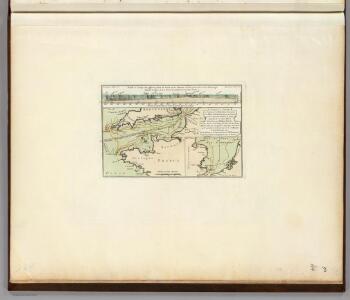
1 : 4300000 Desmarest, Nicolas, 1725-1815
Cartes et coupe du Canal de la Manche et d'une partie de la mer d'Allemagne qui présentent par une nouvelle méthode la pente du fonds de ces deux mers
1 Karte : Kupferdruck ; 16 x 23 cm, Blattgrösse 46 x 61 cm Buache Philippe Buache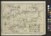
A Chart of the English Channel with the adjacent coasts of England and France.
from Atlantic Ocean
Feuille 23 (B IV), uit: Carte géologique internationale de l'Europe : la carte, votée au congrès géologique international de Bologne en 1881, est exécutée conformément aux décisions d'une commission internationale, avec le concours des gouvernements, sous le dir. de M.M. Beyrich et Hauchecorne
Annotatie: Blad 48 gamme des couleurs; blad 49: bladwijzer en titelblad Heinrich Ernst Beyrich 1815-1896; Wi. Hauchecorne Berlin : Reimer / (Berlin: Institut lithographique)
Canalis inter Angliæ et Galliæ littora
1 Karte : Kupferdruck ; 48 x 55 cm Renard gedruckt by L. Renard
Partie, l'Angleterre. Europe 12.
1 : 1641836 Vandermaelen, Philippe, 1795-1869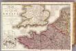
France 1.
1 : 1170000 Herisson, Eustache, b. 1759
43 Sheet A, uit: France (North West), Belgium (West and Central), Holland (part of) ; France (South West), Spain (North)
1 : 1000000 [London : MI9]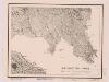
Northwestern France
1 : 2350000 Relief shown by shading. "Base map No. 2995 (free)." "January 14, 1944." Oriented with north to the bottom. United States. Office of Strategic Services. Research and Analysis Branch [Washington, D.C.] : R & A, OSS
La Manche
1 Karte : Kupferdruck ; 50 x 61 cm Jefferys; Le Rouge chez Le Rouge géographe du roi rue des g.ds Augustins
La Manche
1 Karte : Kupferdruck ; 50 x 61 cm Jefferys; Le Rouge chez Le Rouge géographe du roi rue des g.ds Augustins
Carte de la Manche
1 Karte : Kupferdruck ; 50 x 66 cm Lattré chéz Lattré graveur ordinaire du roi de M. le duc d'Orléans et de la ville rue St. Jacques la porte cochère en face de la rue de la Parcheminerie
Pas caart van de canaal tusschen Engeland en Vrancrijck
1 Karte : Kupferdruck ; 43 x 53 cm Doncker by Hendrick Doncker boeckverkoper en graedbooghmaecker inde Nieuwbrugsteegh in 't Stuurmans gereedschap
France N.
1 : 1750000 Andree, Richard; Times (London, England)
Manica, gallis la Manche, et belgis het Canaal, pars oceani inter Angliam et Gallicam
1 Karte : Kupferdruck ; 46 x 55 cm Visscher; Gouwen Nicolaes Visscher
La Manche, ou le Canal, entre la France et l'Angleterre
1 Karte : Kupferdruck ; 49 x 59 cm Jaillot; Goere H. Jaillot
Le royaume de France, 1
1 Blatt : 60 x 44 cm Jaillot
A chart of the British Channel.
1 : 1780000 Jefferys, Thomas
To the right honorable the Masters, Wardens and Eldeil Brother of the Trinity House, this chart of the English Channel: Downs and Margaret; Plysmouth; Falmouth; Portsmouth; Dartmouth
7 Carta nàutica. - Conté carta nàutica de: Dartmouth; Downs and Margate; Plymouth; Falmouth; The Owers Light; Portsmouth Heather, William W. Heather
Les isles Britanniques, 2
2 Blätter : 53 x 85 cm Desnos
France I.
1 : 1800000 Society for the Diffusion of Useful Knowledge (Great Britain)
Le royaume d'Angleterre
1 Karte auf 2 Blättern : Kupferdruck ; 74 x 57 cm Sanson; Jaillot chez H. Iaillot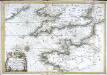
Carte de la Manche
1 Karte : Kupferdruck ; 47 x 68 cm Denis; Basset; Basset chés Basset rue St. Jacques au coin de celle des Mathurins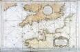
Carte reduite de la Manche
1 Karte : Kupferdruck ; 54 x 83 cm Bellin s.n.
Angleterre, Galles.
1 : 1700000 Brue, Adrien Hubert, 1786-1832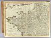
N.W. France.
1 : 1000000 Robert Laurie & James Whittle
Angleterre, Galles.
1 : 1700000 Picquet, C.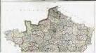
Carte de la France suivant sa nouvelle division en departements et disricts, 1
2 Blätter : 64 x 117 cm s.n.
32-34. Francia nord.
1 : 1500000 Touring club italiano