Maps of Normandy
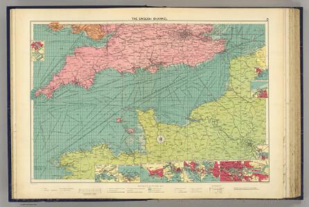
English Channel.
1 : 1500000 Philip, George
English Channel. Pergamon World Atlas.
1 : 1250000 Polish Army Topography Service
La Manche.
1 : 2100000 Vincent

Carte De La Manche. [Karte], in: Atlas nouveau, contenant toutes les parties du monde [...], Bd. 1, S. 53.
1 Karte aus Atlas Sanson, Nicolas Jaillot, Alexis Hubert und Mortier, Pieter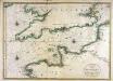
Carte de la Manche
1 Karte : Kupferdruck ; 56 x 79 cm Jaillot; Sanson chez Hubert Jaillot
La Manche, ou le Canal, entre la France et l'Angleterre
1 Karte : Kupferdruck ; 49 x 59 cm Jaillot; Goere H. Jaillot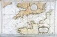
Carte reduite de la Manche
1 Karte : Kupferdruck ; 54 x 83 cm Bellin s.n.
France I.
1 : 1800000 Society for the Diffusion of Useful Knowledge (Great Britain)
La Manche
1 Karte : Kupferdruck ; 50 x 61 cm Jefferys; Le Rouge chez Le Rouge géographe du roi rue des g.ds Augustins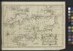
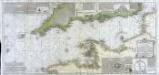
A Chart of the English Channel with the adjacent coasts of England and France.
from Atlantic Ocean
La Manche
1 Karte : Kupferdruck ; 50 x 61 cm Jefferys; Le Rouge chez Le Rouge géographe du roi rue des g.ds Augustins
Carte de la Manche
1 Karte : Kupferdruck ; 50 x 66 cm Lattré chéz Lattré graveur ordinaire du roi de M. le duc d'Orléans et de la ville rue St. Jacques la porte cochère en face de la rue de la Parcheminerie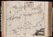
Pascaert van 't Canaal tusschen Engeland en Vranckryck
1 : 1150000 Annotatie: Oorspr. verschenen in: Zee atlas. - 't Amsterdam : by Jacobus Robyn, 1683; Origineel is Blad 25 in atlas factice [Amsterdam : gedruckt bij J. Robijn]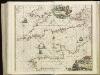
[130][133] Pascaert van 't Canaal tusschen Engeland en Vranckryck, uit: Atlas sive Descriptio terrarum orbis
Annotatie: Gedigitaliseerde versie. Amsterdam. Heiloo : Picturae (vervaardiger), 2015. tiff-bestand. Gedigitaliseerd: 07-01-2015; Origineel: Universiteitsbibliotheek Vrije Universiteit (XL.05127.-) ; Netherlands; Titelpagina ontbreekt Wit, Frederik de Amsterdam : Frederick de Wit
Canalis inter Angliæ et Galliæ littora
1 Karte : Kupferdruck ; 48 x 55 cm Renard gedruckt by L. Renard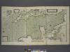
A new and correct draught of the CHANNELL between ENGLAND and FRANCE
from The sea-atlas : containing an hydrographical description of most of the sea-coasts of the known parts of the world.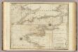
A chart of the British Channel.
1 : 1780000 Jefferys, Thomas
British Channel.
1 : 790000 Thomson, John
43 Sheet A, uit: France (North West), Belgium (West and Central), Holland (part of) ; France (South West), Spain (North)
1 : 1000000 [London : MI9]
Manica, gallis la Manche, et belgis het Canaal, pars oceani inter Angliam et Gallicam
1 Karte : Kupferdruck ; 46 x 55 cm Visscher; Gouwen Nicolaes Visscher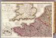
France 1.
1 : 1170000 Herisson, Eustache, b. 1759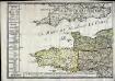
Le royaume de la France occidentale dit autrement Neustrie
1 Karte : Kupferdruck ; 39 x 49 cm, Bildgrösse 41 x 56 cm Duval chez l'auteur en l'isle du Palais sur le quay de l'Orloge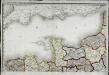
Carte de la république de France, no. 1
1 Blatt : 41 x 59 cm s.n.
Carte de la France, 1
2 Blätter : mehrfarbig ; 72 x 81 cm de Belleyme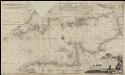
Nieuwe groote verbêterde en corekte gelijkgradige paskaart van het Canaal tusschen Engeland en Vrankerijk, als mede het verkeerde Canaal, met de droogtens, dieptens en de waatergetijden &a =
1 : 675000 naaukeurich opgestelt en in't ligt gebragt door [...] Chfel. Middagten Joan van Luchtenburch [...] delineavit et schulpcit [!] Amsterdam : bij J. Loots, boek en zeekaart verkooper in de Nieuwebrugsteeg in de Jonge Lootsman
Carte de la Manche ou du Canal qui sépare les côtes de France d'avec celles d'Angleterre
1 Karte auf 2 Blättern : Kupferdruck ; 50 x 107 cm Beaurain; Martinet; Vallet chez le chevalier de Beaurain rue Git le cœur la 1.re porte à droite par le quay des Augustins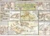
Tableau hidrographique qui contient le détail maritime des principaux ports qui se trouvent rèprèsentés dans la carte de la Manche
13 Karten auf einem Blatt : Kupferdruck ; Bildgrösse 47 x 70 cm Beaurain chez l'auteur rue Git-le Cœur la I.ere porte cochere à droite par le quai des Augustins