Maps of Belgium
Carte des iles britanniques ou Royaume-Uni de la Grande Bretagne et d'Irlande, 6
2 Blätter : je 50 x 39 cm
Map of the Seat of War in France.
1 : 2600000 Carey, Mathew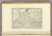
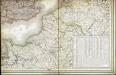
Map of the Seat of War in France, with the Country divided into its Several Departments.
1 : 2700000 Carey, Mathew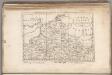
Map of the Seat of War in France, with the Country divided into its Several Departments.
1 : 2700000 Carey, Mathew
67-68. North-East France, Belgium, Luxemburg. The World Atlas.
1 : 1250000 USSR (Union of Soviet Socialist Republics).
A map of the seat of war in France, with the country divided into its several departments
1 : 2600000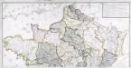
Carte générale des fleuves, des rivieres, et des principaux ruisseaux de la France, 1
1 Blatt : chez l'auteur Dupain-Triel
Descriptio Germaniae Inferioris. [Karte], in: Theatrum orbis terrarum, S. 162.
1 Karte aus Atlas Ortelius, Abraham Vrients, Jan Baptista
Descriptio Germaniae Inferioris. [Karte], in: Theatrum orbis terrarum, S. 42.
1 Karte aus Atlas Ortelius, Abraham
[Recto], uit: Descriptio Germaniae Inferioris
1 : 1000000 Annotatie: Waarschijnlijk gegraveerd door F. Hogenberg; Uit: Theatrum Orbis Terrarm. - Antwerpen, 1570 Hogenberg, Franz [Antwerpen : Abraham Ortelius]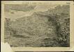
The seat of war in France, showing the scene of M'Mahon's defeat and capitulation, Paris and its environs, and its railroad connections with Tours, Cherbourg, Havre and other cities
1 : 1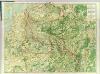
Map Western Front.
1 : 633600 C.S. Hammond & Company
Flanders or the Spanish Provinces.
from A new systeme of the mathematicks: containing I. Arithmetick, as well natural and decimal, as in species, or the principles of algebra. II. Practical geometry, together with the first six books of Euclid's Elements, as also the eleventh and twelfth, symbo
Germaniae Cisrhenanae ut inter J. Caesaris et Trajani fuit imperia Scaldis item Mosae ac Rheni Ostiorum Antiqua descriptio.
1 : 2500000 [S.l.] : [s.n.]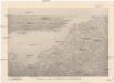
Reliefkarte des Kanals von Cherbourg bis zur Scheldemündung
Anglie jihovýchodní Franckh'sche Verlagshandlung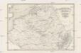
Kriegsschauplatz der Niederlande eines Theils von Holland und am Rhein
Nizozemsko Lehnhardt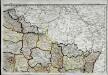
Carte de la république de France, no. 2
1 Blatt : 41 x 58 cm s.n.
Paasche's Frontenkarte, Nr.15. Der Krieg gegen Russland

Karten des französisch-belgischen Kriegsschaplatzes
1 : 1000000 Belgie Velhagen & Klasing
Europe Centrale (Partie Occidentale).
1 : 1750000 Jouvet et Cie.
Paasche's Frontenkarte, Nr.4. Der Krieg gegen Russland

Distribution of German forces on the Western Front
1 : 750000 First World War map of the distribution of German forces on the Western Front according to captured map dates 30th Oct. 1918. Title of base sheet 'Map of the Western Theatre of War'. War Office
Paasche's Frontenkarte, Nr.14. Der Krieg gegen Russland

Paasche's Frontenkarte, Nr.13. Der Krieg gegen Russland

France II.
1 : 1750000 Society for the Diffusion of Useful Knowledge (Great Britain)
Belgii XVII. Provintiarum. Universa Tabula Ad Usum Serenissimi Burgundiae Ducis
1 : 1000000 Mollova mapová sbírka Jaillot, Alexis-Hubert Jaillot, Alexis Hubert
The Spanish Netherlands.
from A system of geography, or, A new & accurate description of the earth in all its empires, kingdoms and states : illustrated with history and topography, and maps of every country : fairly engraven on copper, according to the latest discoveries and corrections / by Herman Moll.
Paasche's Frontenkarte, Nr.17. Der Krieg gegen Russland

Belgivm sive Inferior Germania
1 : 1500000 Mollova mapová sbírka Weigel, Christoph Goos, Abraham Weigel, Christoph I.


