Maps of Hauts-de-France
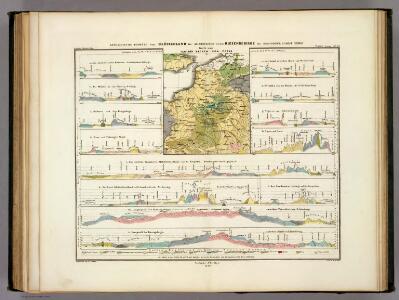
Geologische Profile von Deutschland im Allgemeinen.
1 : 3870000 Berghaus, Heinrich
[Geologische Profile von Deutschland im Allgemeinen u. vom Riesengebirge im besondern]
Erster Band, enthaltend in vier Abtheilungen die Erscheinungen der anorganischen Natur: 1. Meteorologie und Klimatographie. 2. Hydrologie und Hydrographie. 3. Geologie. 4. Tellurischer Magnetismus Humboldt, Alexander von Verlag von Justus Perthes
Der Canal mit den Englischen und Französischen Küsten
Geologischer Atlas zur Naturgeschichte der Erde Leonhard, Carl Cäsar von E. Schweizerbart'sche Verlagsbuchhandlung
Théatre de la guerre, ou carte des frontières de la république française et de l'empire d'Allemagne, 1
1 Teil : Delamarche
Gallia Belgica et Germania Vtraqve Cisrhenana Svperior et Inferior excvsa
1 : 26000000 Mollova mapová sbírka Weigel, Christoph Weigel, Christoph I.
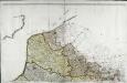
Nordost-Frankreich und Belgien
1 : 750000 Belgie Justus Perthes
La Seine.
1 : 1400000 Buache, Philippe, 1700-1773
A map of the seat of war in France, with the country divided into its several departments
1 : 2600000
Carte géographique et physique du bassin terrestre de la Seine
1 Karte : Kupferdruck ; 27 x 34 cm, Blattgrösse 46 x 61 cm Buache Philippe Buache
Les gouvernements de Flandre, de Picardie, d'Artois, de l'Isle de France, et de Champagne
1 : 5840000 Artois (Francie) Bonne, Rigobert André
Panoramatic View of the frontier between France and Germany
1 : 771000 Francie Meinhard, R. Julius Abelsdorff
Paasche's Frontenkarte, Nr.4. Der Krieg gegen Russland
The seat of war in France, showing the scene of M'Mahon's defeat and capitulation, Paris and its environs, and its railroad connections with Tours, Cherbourg, Havre and other cities
1 : 1
Reliefkarte des Kanals von Cherbourg bis zur Scheldemündung
Anglie jihovýchodní Franckh'sche Verlagshandlung
Paasche's Frontenkarte, Nr.14. Der Krieg gegen Russland

Paasche's Frontenkarte, Nr.15. Der Krieg gegen Russland


Paasche's Frontenkarte, Nr.17. Der Krieg gegen Russland

Paasche's Frontenkarte, Nr.13. Der Krieg gegen Russland

Région Nord comprenant les XI departements du Nord de la France
1 Karte : Kupferdruck ; 53 x 46 cm Lotter; Lotter Lotter
Karte von Frankreich in XVI Blättern, No. 2 und [No. 6]
2 Blätter : 52 x 34 cm Königl. Preuss. Academischen Kunst und Buchhandlung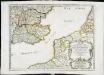
Anciens royaumes de Kent, d'Essex, et de Sussex
1 Karte : Kupferdruck ; 36 x 47 cm Sanson chez l'auteur pres de S. Germain l'Auxerrois
Carte de la France, no. 1
1 Blatt : 60 x 92 cm s.n.
Reliefkarte des Kanals von Cherbourg bis zur Scheldemündung mit Südost - England und Nordfrankreich

Carte des gouvernements de Flandre françoise, d'Artois, de Picardie et du Boulenois
1 Karte : Kupferdruck ; 42 x 55 cm Bonne; Santini; Remondini chez Mr. Remondini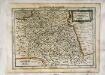
France, Picardie, Champaigne
1 Karte : Kupferdruck ; 18 x 24 cm Mercator Cloppenburgh
Ile de France, Orleanois.
1 : 930000 Bonne, Rigobert, 1727-1794
Comitatus Flandriae in omnes ejusdem subjacentes ditio[n]es cum adjacentibus acuratißime divisus
1 : 300000 Flandry Homann, Johann Baptist sumtibus Ioh. Bapt. Homanni
Comitatus Flandriae in omnes ejusdem subjacentes ditio[n]es cum adjacentibus acuratißime divisus
1 : 300000 Flandry Homann, Johann Baptist Ioh. Bapt. Homanni