Maps of Belgium
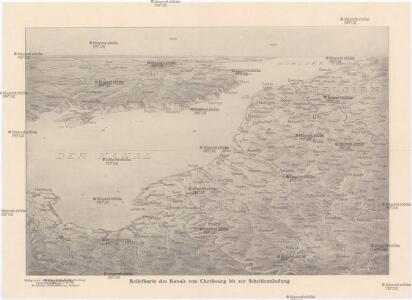
Reliefkarte des Kanals von Cherbourg bis zur Scheldemündung
Anglie jihovýchodní Franckh'sche Verlagshandlung
The seat of war in France, showing the scene of M'Mahon's defeat and capitulation, Paris and its environs, and its railroad connections with Tours, Cherbourg, Havre and other cities
1 : 1
Carte des iles britanniques ou Royaume-Uni de la Grande Bretagne et d'Irlande, 6
2 Blätter : je 50 x 39 cm
A map of the seat of war in France, with the country divided into its several departments
1 : 2600000
Provinciae Belgii regii
1 : 760000 Belgie Danckerts, Justus Iusto Danckerts
PROVINCIAE BELGII REGII
1 : 760000 Belgie Danckerts, Justus Iusto Danckerts
Nova et Accuratißima Galliae Tabula, Vulgo Royaume De France
1 : 920000 Mollova mapová sbírka Danckerts, Justus Danckerts, Justus

Des Burgundischen Creisses Südlicher theil oder Oesterreichissche Niederlande
1 : 2250000 Mollova mapová sbírka Weigel, Christoph Weigel, Christoph I. - dědici
Belgivm Regivm accuratissime descriptum
1 : 1200000 Mollova mapová sbírka Weigel, Christoph Kauffer, Michael Weigel, Christoph I.
Les Provinces des Pays-Bas Catholiques [...] [Karte], in: Atlas nouveau, contenant toutes les parties du monde [...], Bd. 2, S. 20.
1 Karte aus Atlas Sanson, Nicolas Jaillot, Alexis Hubert und Mortier, Pieter
Reliefkarte des Kanals von Cherbourg bis zur Scheldemündung mit Südost - England und Nordfrankreich
Netherlands or Low Countries.
1 : 980000 Bowen, Emanuel
Arena martis in Belgio, qua provinciae X. catholicae inferioris Germaniae
1 : 850000 Belgie Homann, Johann Baptist J. B. Homann
Provinciae Belgii regii distinctae eo, quo sunt hodie divisae modo inter regem Galliae, Hispaniae et ordines provinciarum faederatarum tabula novissima et accuratissima
1 : 740000 1 Karte : Kupferdruck ; 49 x 56 cm Danckerts, Justus [Danckerts]
Provinciae Belgii Regii Distinctae eo, quo Sunt hodie divisae modo Inter Regem Galiae, Hispaniae et Ordines Provinciarum Faederatarum
1 : 740000 Mollova mapová sbírka Danckerts, Justus Danckerts, Justus

Arena Martis in Belgio
1 : 830000 Mollova mapová sbírka Homann, Johann Baptist
Geologische Profile von Deutschland im Allgemeinen.
1 : 3870000 Berghaus, Heinrich

Carte historique de la Belgique au moyen age / par Louis Delgeur
1 : 1135400 Delgeur, Louis [Bruxelles : Vandermaelen]
Belgii Regii accuratissima Tabula. [Karte], in: Novus atlas absolutissimus, Bd. 3, S. 25.
1 Karte aus Atlas Janssonius Offizin
Les provinces des pays-bas Catholiques, ou a most exact map of Flanders or Austrian Netherlands &c.
from The world described, or, A new and correct sett of maps : shewing the kingdoms and states in all the known parts of the earth, with the principal cities, and most considerable towns in the world ... / ... by Herman Moll, geographer ...
BELGII REGII accuratissima Tabula
1 : 810000 Belgie Visscher, Nicolaus Nicolao Visscher
Germaniae inferioris sive Belgii pars meridionalis
1 : 853800 Belgie Lotter, Tobias Conrad M. Tob Conr. Lotter
Germaniae inferioris sive Belgii pars meridionalis
1 : 853800 Belgie Lotter, Tobias Conrad M. Tob Conr. Lotter
Belgii regii tabula
1 : 822000 Belgie Visscher, Nicolaes Jansz. per Nicolaum Visscher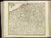
[104][107] Belgii Regii accuratissima tabula pluribus locis, uit: Atlas sive Descriptio terrarum orbis
Annotatie: Gedigitaliseerde versie. Amsterdam. Heiloo : Picturae (vervaardiger), 2015. tiff-bestand. Gedigitaliseerd: 07-01-2015; Origineel: Universiteitsbibliotheek Vrije Universiteit (XL.05127.-) ; Netherlands; Titelpagina ontbreekt Wit, Frederik de Amsterdam : Frederick de Wit
Kriegsschauplatz der Niederlande eines Theils von Holland und am Rhein
Nizozemsko Lehnhardt