Maps of Belgium
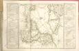
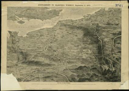
The seat of war in France, showing the scene of M'Mahon's defeat and capitulation, Paris and its environs, and its railroad connections with Tours, Cherbourg, Havre and other cities
1 : 1
Reliefkarte des Kanals von Cherbourg bis zur Scheldemündung
Anglie jihovýchodní Franckh'sche Verlagshandlung
Carte des iles britanniques ou Royaume-Uni de la Grande Bretagne et d'Irlande, 6
2 Blätter : je 50 x 39 cm
France.
1 : 2070000 Rand McNally and Company
A map of the seat of war in France, with the country divided into its several departments
1 : 2600000
Der Canal mit den Englischen und Französischen Küsten
Geologischer Atlas zur Naturgeschichte der Erde Leonhard, Carl Cäsar von E. Schweizerbart'sche Verlagsbuchhandlung
67-68. North-East France, Belgium, Luxemburg. The World Atlas.
1 : 1250000 USSR (Union of Soviet Socialist Republics).
Flanders or the Spanish Provinces.
from A new systeme of the mathematicks: containing I. Arithmetick, as well natural and decimal, as in species, or the principles of algebra. II. Practical geometry, together with the first six books of Euclid's Elements, as also the eleventh and twelfth, symbo
XVII provinciae Belgii sive Germaniae inferioris priscis temporib. circulo Burgundico S. R. I. annumeratae quarum X. hodie maximam partem Hispaniarum non nullae Galliae regis ditioni subjacent, VII vero sub nomine foederatarum provinciar libertate gaudent
1 : 1050000 Belgie Seutter, Matthäus Mathaei Seutteri
Belgii XVII. Provintiarum. Universa Tabula Ad Usum Serenissimi Burgundiae Ducis
1 : 1000000 Mollova mapová sbírka Jaillot, Alexis-Hubert Jaillot, Alexis Hubert
Provinciae Belgii regii
1 : 760000 Belgie Danckerts, Justus Iusto Danckerts
PROVINCIAE BELGII REGII
1 : 760000 Belgie Danckerts, Justus Iusto Danckerts
XVII. Provinciae Belgii sive Germaniae Inferioris
1 : 1100000 Mollova mapová sbírka Seutter, Matthäus Seutter, Matthäus
Tabula generalis totius Belgii qua provinciae XVII Infer. Germaniae olim sub S. R. I. circulo Burgundiae comprehensae nunc in Varias Potentias tum liberas utpote Prov. VII Foederatas, tum reliquas Hispaniae, et Galliae coronis subjectas, separata ostenduntur
1 : 1000000 Mollova mapová sbírka Homann, Johann Baptist Homann, Johann Baptista
Belgivm sive Inferior Germania
1 : 1500000 Mollova mapová sbírka Weigel, Christoph Goos, Abraham Weigel, Christoph I.
Gallia Belgica et Germania Vtraqve Cisrhenana Svperior et Inferior excvsa
1 : 26000000 Mollova mapová sbírka Weigel, Christoph Weigel, Christoph I.

Carte historique de la Belgique au moyen age / par Louis Delgeur
1 : 1135400 Delgeur, Louis [Bruxelles : Vandermaelen]
Geologische Profile von Deutschland im Allgemeinen.
1 : 3870000 Berghaus, Heinrich
Kriegsschauplatz der Niederlande eines Theils von Holland und am Rhein
Nizozemsko Lehnhardt
XVII Provinciae Belgii sive Germaniae Inferioris priscis temporibus circulo Burgundisco S.R.I. annumeratae quarum X hodie maximam partem Hispaniarum, non nullae Galliae regis ditioni subjacent, VII vero sub nomine Foederatarum Provinciarum Libertate gaudent
1 : 1250000 studio et opera Tobiae Conradi Lotter G. Rogg del. Augusta [Vindelicorum], : Tobiae Conradi Lotter
XVII Provinciae Belgii sive Germaniae Inferioris priscis temporibus Circulo Burgundico S. R. I. annumeratae, quarum X. hodie maximam partem Hispaniarum, non nullae Galliae Regis ditioni subiacent, VII. vero sub nomine Foederatarum Provinciar. libertate gaudent
1 : 1250000 studio et opera Matthaei Seutteri G. Rogg del. Augusta [Vind.] : Matthaeus Seutter
Die Niederlande und Belgien
1 : 830000 Belgie Kiepert, Heinrich Eulenstein, F. Geographisches Institut
Paasche's Frontenkarte, Nr.4. Der Krieg gegen Russland

Septendecim provinciae Germaniae Inferior. uti sunt sub potestate regum Franciae et Hispaniae Ordinumque Generalium provinciarum unitarum : una cum episcopatibus Monasteriensi, Coloniensi, Leodiensi, et Cameracensi ...
1 : 1000000 P. Schenk exc. Amst. : P. Schenk exc.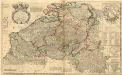
Les Provinces des Pays-Bas Catholiques ou a Most Exact Map of Flanders or Austrian Netherlands &c.
1 : 440000 Mollova mapová sbírka Moll, Herman Bowles, I.