Maps of Grand Est

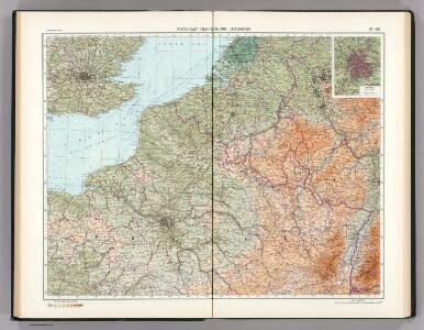
67-68. North-East France, Belgium, Luxemburg. The World Atlas.
1 : 1250000 USSR (Union of Soviet Socialist Republics).
Map Western Front.
1 : 633600 C.S. Hammond & Company
Unsere Westgrenze
1 : 1000000 Evropa západní Velhagen & Klasing
Belgica oder Nieder Teutschland
Belgie Baumgarten, Siegmund Jakob Johann Justinus Gebauer
France N.
1 : 1750000 Andree, Richard; Times (London, England)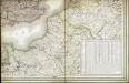
Carte des iles britanniques ou Royaume-Uni de la Grande Bretagne et d'Irlande, 6
2 Blätter : je 50 x 39 cm
Flanders or the Spanish Provinces.
from A new systeme of the mathematicks: containing I. Arithmetick, as well natural and decimal, as in species, or the principles of algebra. II. Practical geometry, together with the first six books of Euclid's Elements, as also the eleventh and twelfth, symbo
The Spanish Netherlands.
from A system of geography, or, A new & accurate description of the earth in all its empires, kingdoms and states : illustrated with history and topography, and maps of every country : fairly engraven on copper, according to the latest discoveries and corrections / by Herman Moll.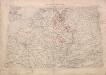
Territory in Western Germany occupied by the Allied Armies
1 : 1000000 First World War map of the territory in Western Germany occupied by the Allied Armies and the stages of evacuation according to article 429 of the peace treaty. Situation for July 1921. War Office
Germaniae Cisrhenanae ut inter J. Caesaris et Trajani fuit imperia Scaldis item Mosae ac Rheni Ostiorum Antiqua descriptio.
1 : 2500000 [S.l.] : [s.n.]
Descriptio Germaniae Inferioris. [Karte], in: Theatrum orbis terrarum, S. 162.
1 Karte aus Atlas Ortelius, Abraham Vrients, Jan Baptista
Paasche's Frontenkarte, Nr.4. Der Krieg gegen Russland

Paasche's Frontenkarte, Nr.15. Der Krieg gegen Russland

Karten des französisch-belgischen Kriegsschaplatzes
1 : 1000000 Belgie Velhagen & Klasing
Paasche's Frontenkarte, Nr.13. Der Krieg gegen Russland

Paasche's Frontenkarte, Nr.14. Der Krieg gegen Russland

Descriptio Germaniae Inferioris. [Karte], in: Theatrum orbis terrarum, S. 42.
1 Karte aus Atlas Ortelius, Abraham
Kriegsschauplatz oder Graenzkarte zwischen Deutschland und Franckreich
1 Karte auf 2 Blättern : Kupferdruck ; 61 x 56 cm Walch zu haben bei Ioh. Walch im eignem Kunstverlag
[Recto], uit: Descriptio Germaniae Inferioris
1 : 1000000 Annotatie: Waarschijnlijk gegraveerd door F. Hogenberg; Uit: Theatrum Orbis Terrarm. - Antwerpen, 1570 Hogenberg, Franz [Antwerpen : Abraham Ortelius]
Skizze zur Orientirung ϋber den Feldzug 1795

Carte des peuples riverains du Rhin au temps d’Auguste et de ses successeurs immédiats
Mitteleuropa Rhein-Gebiet ethnische Gruppe Germanen
Theatrum Belli Serenissimae Domus Austriacae
1 : 410000 Mollova mapová sbírka Oettinger, Johann Friedrich Seutter, Matthäus
Theatrum Belli Serenissimae Domus Austriacae
1 : 410000 Mollova mapová sbírka Oettinger, Johann Friedrich Seutter, Matthäus
Theatrum Belli Serenissimae Domus Austriacae
1 : 410000 Mollova mapová sbírka Oettinger, Johann Friedrich Seutter, Matthäus
Theatrum Belli Serenissimae Domus Austriacae
1 : 410000 Mollova mapová sbírka Oettinger, Johann Friedrich Seutter, Matthäus
Theatrum Belli Serenissimae Domus Austriacae
1 : 410000 Mollova mapová sbírka Oettinger, Johann Friedrich Seutter, Matthäus
Theatrum Belli Serenissimae Domus Austriacae
1 : 410000 Mollova mapová sbírka Oettinger, Johann Friedrich Seutter, Matthäus
Gallia Belgica et Germania Vtraqve Cisrhenana Svperior et Inferior excvsa
1 : 26000000 Mollova mapová sbírka Weigel, Christoph Weigel, Christoph I.
Distribution of German forces on the Western Front
1 : 750000 First World War map of the distribution of German forces on the Western Front according to captured map dates 30th Oct. 1918. Title of base sheet 'Map of the Western Theatre of War'. War Office