Maps of British Isles

BRITANNIA | prout divisa suit temporibus | ANGLO-SAXONVM [...].
[Amsterdam : Joan Blaeu]
Firing ranges, UK
Great Britain War Office General Staff Geographical Section
A new map of Great Britain.
from The world described, or, A new and correct sett of maps : shewing the kingdoms and states in all the known parts of the earth, with the principal cities, and most considerable towns in the world ... / ... by Herman Moll, geographer ...
RAF map of Danger Areas in the United Kingdom (Permanent sites)
Great Britain War Office General Staff Geographical Section Ordnance Survey
(La Grande-Bretagne)
1 : 12000000 Bruyset, Jean-Marie; Schneider, J. H.
Insularum Britannicarum acurata delineatio ex geographicis conatibus Abrahami Ortelii
1 : 2500000 Petrus Kaerius caelavit Amstelodami : apud Joannem Janssonium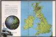
The British Isles
1 : 3000000 Debenham, Frank
Britannicarum insularum typus / ex conatibus geographicis Abrah. Ortelius
1 : 2500000 Annotatie: Oorspr. verschenen in: Theatrum Orbis Terrarum opus nunc denuo ... - [Antwerpen : Abraham Ortelius]; Origineel is Blad 24 in atlas factice; Annotatie geografische gegevens: West boven Ortelius, Abraham [Antwerpen : Arbraham Ortelius]
Novissima prae caeteris aliis accuratissima regnorum Angliae, Scotiae, Hiberniae tabula
1 : 1900000 auctore Petri Schenk Amstelodami : Petrus Schenk
Die Britischen Inseln nach ihrer kirchlichen Eintheilung bis zur Reformation.
1 : 3000000 Spruner von Merz, Karl
Grossbritanien.
1 : 3900000 Haller von Hallerstein, Friedrich; Reichard, C. G.
Geographische Carte von Gross-Britannien zum Gebrauch beim Studium der Geschichte
Historisch-genealogisch-geographischer Atlas von Le Sage Las Cases, Emmanuel Auguste Dieudonné Marius Joseph de Johann Velten, Kunsthändler
Britische Inseln
Neuer Handatlas über alle Theile der Erde Kiepert, Heinrich Verlag von Dietrich Reimer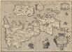
Britannicarum Insularum Typus. [Karte], in: Theatrum orbis terrarum, S. 456.
1 Karte aus Atlas Ortelius, Abraham Vrients, Jan Baptista
Die Britischen Inseln oder die Vereinigten Königreiche
1 : 1850000 Normanské ostrovy Kiepert, Heinrich Gräf, C. Geographisches Institut
Welká Britanie a Iry
1 : 3400000 Irsko Merklas, Václav W. Merklas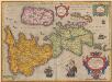
Britannicarum Insularum Typus. [Karte], in: Theatrum orbis terrarum, S. 365.
1 Karte aus Atlas Ortelius, Abraham
TABULA NOVISSIMA ACCURATISSIMA REGNORUM ANGLIAE, SCOTIAE HIBERNIAE
1 : 1900000 Anglie Seutter, Matthäus Mattheo Seutter
Tabula novissima accuratissima regnorum Angliae, Scotiae Hiberniae
1 : 1900000 Irsko Seutter, Matthäus M. Seutter
Nouvelle carte d'Angleterre, d'Ecosse et d'Irlande
1 Karte : Kupferdruck ; 44 x 49 cm Châtelain s.n.
Insularum Britannicarum Acurata Delineatio ex Geographicis Conatibus Abrahami Ortelii [Karte], in: Novus atlas absolutissimus, Bd. 7, S. 14.
1 Karte aus Atlas Janssonius Offizin
Tabula novissima accuratissima regnorum Angliae, Scotiae Hiberniae
1 : 1850000 Irsko Seutter, Matthäus Mattheo Seutter
Welká Britanie a Iry

British Isles - railways & industrial.
1 : 2000000 John Bartholomew & Co.
British Isles - bathy-orographical.
1 : 2000000 John Bartholomew & Co.
British Isles - political.
1 : 2000000 John Bartholomew & Co.

British Isles.
1 : 2950000 Wauthier, J. M.
Plain map British Islands.
1 : 2950000 Wauthier, J. M.
![BRITANNIA | prout divisa suit temporibus | ANGLO-SAXONVM [...].](https://images-2.georeferencer.com/images/iiif/157630456833/full/,300/0/native.jpg)

