Maps of British Isles

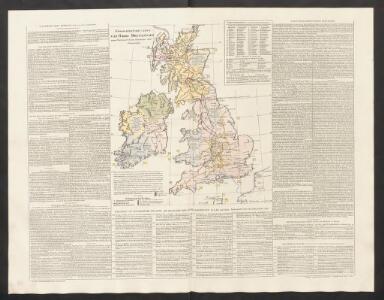
Geographische Carte von Gross-Britannien zum Gebrauch beim Studium der Geschichte
Historisch-genealogisch-geographischer Atlas von Le Sage Las Cases, Emmanuel Auguste Dieudonné Marius Joseph de Johann Velten, Kunsthändler
Nouvelle carte d'Angleterre, d'Ecosse et d'Irlande
1 Karte : Kupferdruck ; 44 x 49 cm Châtelain s.n.
Grossbritanien.
1 : 3900000 Haller von Hallerstein, Friedrich; Reichard, C. G.
Bradshaw's new railway map of Gt. Britain and Ireland shewing the stations-distance &c.
1 : 1560000 Bradshaw & Blacklock
Britannicæ insulæ
1 Karte : Kupferdruck ; 39 x 51 cm Sanson; Robert de Vaugondy chés le Sr. Robert geog. ord. du roy quay de l'horloge du Palais
Isles Britanniques.
1 : 2600000 Jouvet et Cie.
British Isles (outline)
1 : 4500000 Patteson, Edward
British Isles.
1 : 4500000 Patteson, Edward
Britische Inseln
Volksschul-Atlas über alle Teile der Erde Lange, Henry Druck und Verlag von Georg Westermann
Carte des grandes routes d'Angleterre, d'Ecosse, et d'Irlande
1 Karte : Kupferdruck ; 46 x 57 cm Robert de Vaugondy; Haussard s.n.
Magnæ Britanniæ tabula
1 Karte : Kupferdruck ; 46 x 55 cm Visscher; Schenk nunc apud P. Schenk jun
Novissima et accuratissima totius Angliæ, Scotiæ et Hiberniæ tabula
1 Karte : Kupferdruck ; 49 x 56 cm Danckerts Danckerts
Magnæ Britanniæ et Hiberniæ nova descriptio
1 Karte : Kupferdruck ; 41 x 52 cm Janssonius apud Ioannem Ianssonium
Accuratissima Angliæ Scotiæ et Hiberniæ tab
1 Karte : Kupferdruck ; 49 x 58 cm Allard by Carolus Allard op den Dam
Magnæ Britanniæ tabula, Angliam, Scotiam, et Hiberniam continens
1 Karte : Kupferdruck ; 44 x 55 cm Ram in lucem edita per Ioannem de Ram
Novissima et accuratissima totius Angliæ Scotiæ et Hiberniæ tabula
1 Karte : Kupferdruck ; 48 x 55 cm Danckerts; Homann; Funck David Funck excudit
Nova totius Angliæ, Scotiæ, et Hiberniæ tab
1 Karte : Kupferdruck ; 46 x 54 cm Schagen by Gerrit v. Schagen voor aen op de Haerlemmerdyck inde Stuerman
Nova totius Angliæ, Scotiæ, et Hiberniæ tab
1 Karte : Kupferdruck ; 47 x 55 cm Wit by Frederick de Wit in de Kalverstraet by den dam inde Witte Pascaert
Nieuwe perfecte carte van Engelant Schotlant en Ierlant
1 Karte : Kupferdruck ; 41 x 52 cm Wit by Frederick de Wit
Magnæ Britanniæ et Hiberniæ tabvla
1 Karte : Kupferdruck ; 36 x 48 cm Blaeu Guıljelmus Blaeuw excudit
Novissima et accuratissima totius Angliae, Scotiae et Hiberniae tabula
1 : 2100000 1 Karte : Kupferdruck ; 49 x 56 cm Danckerts, Theodorus [Danckerts]
Geology Of The British Isles.
1 : 1025000 Wyld, James, 1812-1887
Carte Physique et Mineralogique des Isles Britanniques
1 : 15000000 Malte-Brun, Conrad, 1775-1826
The British Isles
1 : 3000000 Debenham, Frank
Britannicæ insulæ
1 Karte : Kupferdruck ; 46 x 51 cm Sanson; Robert de Vaugondy; Santini; Remondini chez Mr. Remondini
Britannicæ insulæ
1 Karte : Kupferdruck ; 47 x 52 cm Robert de Vaugondy; Sanson; Delahaye G. et D. Robert de Vaugondy
Welká Britanie a Iry

Britania et Hibernia
1 : 3000000 Irsko, ostrov Spruner, Karl von Justus Perthes
Atlas für Handel und Industrie: Für Kaufleute, Fabrikante u. Gewerbetreibende, Handlungs- u. Gewerbe-Schulen