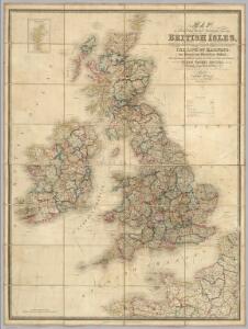
Maps of British Isles

Geology Of The British Isles.
1 : 1025000 Wyld, James, 1812-1887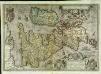
Angliae, Scotiae, et Hiberniæ, sive Britannicar: insularum descriptio
1 Karte : Kupferdruck ; 33 x 47 cm Janssonius excudebat Ioannes Ianssonius
Angliae, Scotiae, et Hiberniae, sive Britannicar: insvlarvm descriptio
1 Karte : Kupferdruck ; 33 x 48 cm Ortelius s.n.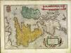
Angliae, Scotiae, et Hiberniae, sive Britannicar: insvlarvm descriptio
1 Karte : Kupferdruck ; 33 x 49 cm Ortelius s.n.
Carte de l' Angleterre
1 : 5900000 Velká Británie Delamarche, Francois Alexander
Isles Britanniques.
1 : 2600000 Jouvet et Cie.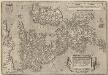
Angliae, Scotiae, Et Hiberniae, Sive Britannicar: Insularum Descriptio. [Karte], in: Theatrum orbis terrarum, S. 77.
1 Karte aus Atlas Ortelius, Abraham Vrients, Jan Baptista
Bradshaw's new railway map of Gt. Britain and Ireland shewing the stations-distance &c.
1 : 1560000 Bradshaw & Blacklock
Carte générale des Iles Britanniques
1 : 2750000 par A.H. Brué Paris : chez l'auteur [etc.]
Carte des isles Britanniques et de la Manche
1 Karte : Kupferdruck ; 72 x 49 cm Brion de la Tour; Esnault; Rapilly chez Esnauts et Rapilly rue S. Jacques à la ville de Coutances

British Isles railways.
1 : 1800000 Philip, George
Iles Britanniques.
1 : 2500000 Brue, Adrien Hubert, 1786-1832
Karte des Brittischen Reichs
1 : 2700000 Irsko Brué, Adrien Hubert bey Artaria et Comp.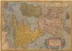
Angliae, Scotiae, Et Hiberniae, Sive Britaniicar: Insularum Descriptio. [Karte], in: Theatrum orbis terrarum, S. 24.
1 Karte aus Atlas Ortelius, Abraham
Britische Inseln
Volksschul-Atlas über alle Teile der Erde Lange, Henry Druck und Verlag von Georg Westermann
Pascaart Vant Canaal Tuẞchen Engelant en Vrancryck [...] [Karte], in: Het vijfde Deel Des Grooten Atlas : Vervatende De Water-Weereld, S. 160.
1 Karte aus Atlas Jansson, Jan Jansson, Jan
Iles Britanniques.
1 : 2950000 Montemont, A.
Iles Britanniques.
1 : 2500000 Picquet, C.
Great Britain and Ireland. Pergamon World Atlas.
1 : 2500000 Polish Army Topography Service
Britannicæ insulæ
1 Karte : Kupferdruck ; 39 x 51 cm Sanson; Robert de Vaugondy chés le Sr. Robert geog. ord. du roy quay de l'horloge du Palais
British Isles (outline)
1 : 4500000 Patteson, Edward
British Isles.
1 : 4500000 Patteson, Edward
Grossbritanien.
1 : 3900000 Haller von Hallerstein, Friedrich; Reichard, C. G.
Welká Britanie a Iry
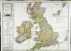
Carte des isles Britanniques qui renferment les royaumes d'Angleterre d'Ecosse [et] d'Irlande
1 Karte : Kupferdruck ; 53 x 59 cm Robert de Vaugondy; Beaublé; Fortin; Kitchin chés Fortin ingénieur du roi pour les globes et sphéres rue de la Harpe près celle du Foin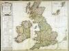
Carte des isles Britanniques qui renferment les royaumes d'Angleterre d'Ecosse [et] d'Irlande
1 Karte : Kupferdruck ; 53 x 59 cm Robert de Vaugondy; Beaublé; Delamarche; Kitchin chez le Sr. Delamarche géographe rue du Foin St. Jacques au collège de m.tre Gervais
Pascaart Vant Canaal [...] Tabula Hydrographica Freti seu Canalis [...] quod est Inter Angliam et Galliam, nec non Hiberniam et Scotiam [...] [Karte], in: Novus atlas absolutissimus, Bd. 9, S. 213.
1 Karte aus Atlas Janssonius Offizin
Grossbritannien
Plastischer Schul-Atlas über alle Theile der Erde : in 24 Karten Woldermann, G Verlag von P. Eckerlein