Maps of British Isles
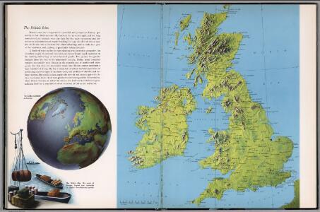
The British Isles
1 : 3000000 Debenham, Frank
Britania et Hibernia
1 : 3000000 Irsko, ostrov Spruner, Karl von Justus Perthes
Die Britischen Inseln nach ihrer kirchlichen Eintheilung bis zur Reformation.
1 : 3000000 Spruner von Merz, Karl
Die Britischen Inseln 1066 bis 1485.
1 : 3100000 Spruner von Merz, Karl
A new map of the Brittish Isles shewing their antient people, cities, and towns of note, in the time of the Romans
1 : 2846000
British Isles.
1 : 2500000 Andree, Richard; Times (London, England)
Großbritannien und Irland
1 : 1000000 Irsko Velhagen & Klasing
A new map of the Brittish Isles shewing their present genl. divisions, cities, and such other towns, or places, as answer to the towns of note in the time of the Romans
1 : 2851200
Britische Inseln
Volksschul-Atlas über alle Teile der Erde Lange, Henry Druck und Verlag von Georg Westermann
Die Britischen Inseln seit 1485.
1 : 3000000 Spruner von Merz, Karl
Magnae Britanniae et Hiberniae Tabula
1 : 2300000
Soubor němých map pro gymnasia a odborné školy

Philips Railway map of the British Isles

Britischen Inseln.
1 : 1800000 Kiepert, Heinrich, 1818-1899
British Islands.
1 : 5500000 Fitch, George W.
Gt. Britain, Ireland.
1 : 4800000 Mitchell, Samuel Augustus
Iles Britanniques.
1 : 2500000 Andriveau-Goujon, J.
British Isles.
1 : 5000000 Adams, Daniel
Nova totius Angliae, Scotiae, et Hiberniae tab: / auctore Frederick de Wit
1 : 2250000 Annotatie: Origineel is Blad 22 in atlas factice; Annotatie geografische gegevens: Met 3 schaalstokken Frederick de Wit 1630-1706 'T Amsterdam : by Frederick de Wit
[Grossbritannien; England, Scotland und Ireland]
Geographischer Atlas über alle Theile der Erde Ziegler, Jakob Melchior Verlag von Joh. Wurster um Comp.
Grossbritanien.
1 : 3900000 Haller von Hallerstein, Friedrich; Reichard, C. G.
Karte des Brittischen Reichs
1 : 2700000 Irsko Brué, Adrien Hubert bey Artaria et Comp.

Magnae Britanniae et Hiberniae nova descriptio
1 : 2500000 Amstelodami : apud Joannem Janssonium
Die Britischen Inseln
E. von Sydow's Schul-Atlas in sechs und dreissig Karten Sydow, Emil von bei Justus Perthes
Britannicae Insulae in quibus Albion seu Britannia Major, et Ivernia seu Britannia Minor ...
1 : 2300000
Geographische Carte von Gross-Britannien zum Gebrauch beim Studium der Geschichte
Historisch-genealogisch-geographischer Atlas von Le Sage Las Cases, Emmanuel Auguste Dieudonné Marius Joseph de Johann Velten, Kunsthändler
[Grossbritannien; England, Scotland und Ireland]
Geographischer Atlas über alle Theile der Erde Ziegler, Jakob Melchior Verlag von Dietrich Reimer
[85][85] Nova totius Angliae, Scotiae, et Hiberniae tab:, uit: Atlas sive Descriptio terrarum orbis
Annotatie: Gedigitaliseerde versie. Amsterdam. Heiloo : Picturae (vervaardiger), 2015. tiff-bestand. Gedigitaliseerd: 07-01-2015; Origineel: Universiteitsbibliotheek Vrije Universiteit (XL.05127.-) ; Netherlands; Titelpagina ontbreekt Wit, Frederik de Amsterdam : Frederick de Wit