Maps of British Isles

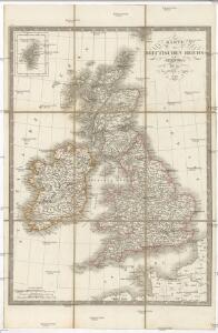
Karte des Brittischen Reichs
1 : 2700000 Irsko Brué, Adrien Hubert bey Artaria et Comp.

Die Britischen Jnseln England, Schotland, Jreland
Stieler's Hand-Atlas Stieler, Adolf bei Justus Perthes
Welká Britanie a Iry

[Grossbritannien; England, Scotland und Ireland]
Geographischer Atlas über alle Theile der Erde Ziegler, Jakob Melchior Verlag von Dietrich Reimer
British Isles.
1 : 2500000 Andree, Richard; Times (London, England)
Die Brittischen Inseln
Schul-Atlas über alle Theile der Erde nach dem neuesten Zustande, und über das Weltgebäude Stieler, Adolf bei Justus Perthes
Map of the British Isles
1 : 908500 Shetlandy (Skotsko) Cary, John
Carte générale des Iles Britanniques
1 : 2750000 par A.H. Brué Paris : chez l'auteur [etc.]
Carte de l' Angleterre
1 : 5900000 Velká Británie Delamarche, Francois Alexander
Britischen Inseln.
1 : 1800000 Kiepert, Heinrich, 1818-1899
British Islands.
1 : 5500000 Fitch, George W.
Gt. Britain, Ireland.
1 : 4800000 Mitchell, Samuel Augustus
Iles Britanniques.
1 : 2500000 Andriveau-Goujon, J.
British Isles.
1 : 5000000 Adams, Daniel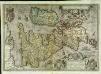
Angliae, Scotiae, et Hiberniæ, sive Britannicar: insularum descriptio
1 Karte : Kupferdruck ; 33 x 47 cm Janssonius excudebat Ioannes Ianssonius
Angliae, Scotiae, et Hiberniae, sive Britannicar: insvlarvm descriptio
1 Karte : Kupferdruck ; 33 x 48 cm Ortelius s.n.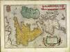
Angliae, Scotiae, et Hiberniae, sive Britannicar: insvlarvm descriptio
1 Karte : Kupferdruck ; 33 x 49 cm Ortelius s.n.
[Grossbritannien; England, Scotland und Ireland]
Geographischer Atlas über alle Theile der Erde Ziegler, Jakob Melchior Verlag von Joh. Wurster um Comp.
Die britischen Inseln
Hypsometrischer Atlas Ziegler, Jakob Melchior Topogr. Anstalt v. J. Wurster u. Comp.
Die Britischen Inseln
E. von Sydow's Schul-Atlas in sechs und dreissig Karten Sydow, Emil von bei Justus Perthes
Britische Inseln
Volksschul-Atlas über alle Teile der Erde Lange, Henry Druck und Verlag von Georg Westermann
Iles Britanniques.
1 : 2950000 Montemont, A.
Carte des isles Britanniques et de la Manche
1 Karte : Kupferdruck ; 72 x 49 cm Brion de la Tour; Esnault; Rapilly chez Esnauts et Rapilly rue S. Jacques à la ville de Coutances
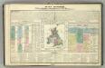
Tableau l'historie des Iles Britanniques.
1 : 8200000 Duval, Henri
Pas-caart van 't Canaal
1 Karte : Kupferdruck ; 44 x 54 cm Doncker bij Hendrick Doncker boekverkooper en graadbooghmaecker inde Nieuwbrughsteegh in 't Stuurmans gereedtschap
Great Britain and Ireland. Pergamon World Atlas.
1 : 2500000 Polish Army Topography Service
Angliae, Scotiae, Et Hiberniae, Sive Britannicar: Insularum Descriptio. [Karte], in: Theatrum orbis terrarum, S. 77.
1 Karte aus Atlas Ortelius, Abraham Vrients, Jan Baptista