Maps of United Kingdom

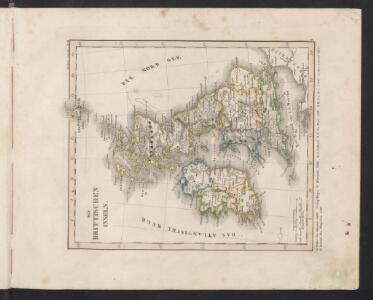
Die Brittischen Inseln
Schul-Atlas über alle Theile der Erde nach dem neuesten Zustande, und über das Weltgebäude Stieler, Adolf bei Justus Perthes
Die britischen Inseln
Hypsometrischer Atlas Ziegler, Jakob Melchior Topogr. Anstalt v. J. Wurster u. Comp.
Die Britischen Inseln
E. von Sydow's Schul-Atlas in sechs und dreissig Karten Sydow, Emil von bei Justus Perthes
Die Britischen Jnseln England, Schotland, Jreland
Stieler's Hand-Atlas Stieler, Adolf bei Justus Perthes
[Grossbritannien; England, Scotland und Ireland]
Geographischer Atlas über alle Theile der Erde Ziegler, Jakob Melchior Verlag von Joh. Wurster um Comp.
Iles Britanniques.
1 : 2500000 Lapie, M. (Pierre), 1779-1850
Die Brittischen Inseln
Schul-Atlas über alle Theile der Erde nach dem neuesten Zustande, und über das Weltgebäude Stieler, Adolf Justus Perthes

Britischen Inseln.
1 : 1800000 Kiepert, Heinrich, 1818-1899
British Islands.
1 : 5500000 Fitch, George W.
Gt. Britain, Ireland.
1 : 4800000 Mitchell, Samuel Augustus
Iles Britanniques.
1 : 2500000 Andriveau-Goujon, J.
British Isles.
1 : 5000000 Adams, Daniel
Map of the British Isles
1 : 908500 Shetlandy (Skotsko) Cary, John
Grossbritanien und Irrland
Allgemeiner Atlas [Walch, Johannes] im Verlag bei Johannes Walch
[Grossbritannien; England, Scotland und Ireland]
Geographischer Atlas über alle Theile der Erde Ziegler, Jakob Melchior Verlag von Dietrich Reimer
Neueste Karte von Grossbritannien und Jreland
Grosser Hand-Atlas über alle Theile der Erde in 170 Karten Meyer, J. Verlag des Bibliographischen Instituts
Welká Britanie a Iry

Britannia Antiqua cum Hibernia
1 : 3618000 Irsko Macpherson, A. Gleditsch
Carte Physique et Mineralogique des Isles Britanniques
1 : 15000000 Malte-Brun, Conrad, 1775-1826
Soubor němých map pro gymnasia a odborné školy

Grossbritannien, Ireland.
1 : 3800000 Flemming, Carl
Tableau l'historie des Iles Britanniques.
1 : 8200000 Duval, Henri
Grossbritannien und Ireland
Isles Britanniques.
1 : 3800000 Janvier, Jean
Composite: Geological, palaeontological map British Islands.
1 : 1550000 Johnston, Alexander Keith, 1804-1871
Insvlæ britannicæ antiqvæ
1 Karte : Kupferdruck ; 31 x 38 cm Weigel Christoph Weigel
58-59. Great Britain and Ireland. The World Atlas.
1 : 2500000 USSR (Union of Soviet Socialist Republics).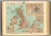
45-46. Gran Bretagna.
1 : 3000000 Touring club italiano