Maps of United Kingdom

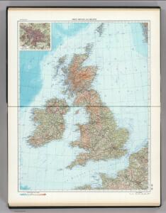
58-59. Great Britain and Ireland. The World Atlas.
1 : 2500000 USSR (Union of Soviet Socialist Republics).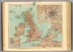
45-46. Gran Bretagna.
1 : 3000000 Touring club italiano
Neueste Karte von Grossbritannien und Jreland
Grosser Hand-Atlas über alle Theile der Erde in 170 Karten Meyer, J. Verlag des Bibliographischen Instituts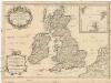
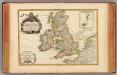
Les isles Britanniques
1 : 2600000 Anglie Sanson, Guillaume Boazius, I.B. chez H. Iaillot
Iles Britanniques.
1 : 2500000 Lapie, M. (Pierre), 1779-1850
British Isles.
1 : 2550000 Cary, John, ca. 1754-1835
Die Brittischen Inseln
Schul-Atlas über alle Theile der Erde nach dem neuesten Zustande, und über das Weltgebäude Stieler, Adolf Justus Perthes
Britannia Antiqua cum Hibernia
1 : 3618000 Irsko Macpherson, A. Gleditsch
Grossbritanien und Irrland
Allgemeiner Atlas [Walch, Johannes] im Verlag bei Johannes Walch
Isles Britanniques.
1 : 3800000 Janvier, Jean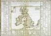
Tableau général des isles Britanniques
1 Karte : Kupferdruck ; 34 x 43 cm, Bildgrösse 52 x 73 cm Brion de la Tour; Le Campion; Le Campion chez les Campions freres m.ds d'estampes rue St. Jacques à la ville de Rouen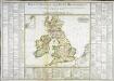
Tableau général des isles Britanniques
1 Karte : Kupferdruck ; 34 x 43 cm, Bildgrösse 52 x 73 cm Brion de la Tour; Le Campion; Le Campion chez les Campions freres m.ds d'estampes rue St. Jacques à la ville de Rouen
Magna Britannia, aut Anglia, Scotia et Hibernia
1 Karte : Kupferdruck ; 46 x 58 cm Valck; Valck G. und L. Valck
Die Britischen Inseln Und Das Umliegende Meer.
1 : 3700000 Petermann, A.
Grossbritannien
Plastischer Schul-Atlas über alle Theile der Erde : in 24 Karten Woldermann, G Verlag von P. Eckerlein
Nieuwe kaart van de eilanden van Groot Brittannien : behelzende de koningryken Engeland, Schotland en Ierland / volgens de laatste waarnemingen in het ligt gebragt ; C. Sepp del. et sculps. 1743
1 : 3500000 Annotatie: Oorspr. verschenen in: Nieuwe hand-atlas ... - Amsterdam : Isaak Tirion, 1744 Sepp, C. Te Amsterdam : by Isaak Tirion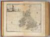
Great Britain & Ireland.
1 : 4250000 Bowen, Emanuel
Die Brittischen Inseln und die Nord-See
Hand-Atlas über alle Theile der Erde nach dem neuesten Zustande und über das Weltgebäude Stieler, Adolf bei Justus Perthes
Magna Britannia et Hibernia
1 Karte : Kupferdruck ; 54 x 45 cm Walch; Kitchin; Dorret Johann Walch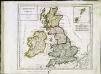
Britannicæ Insulæ
1 Karte : Kupferdruck ; 22 x 25 cm Delamarche s.n.
Die Britischen Inseln und die Nord-See
Hand-Atlas über alle Theile der Erde nach dem neuesten Zustande und über das Weltgebäude Stieler, Adolf bei Justus Perthes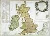
Les isles Britannicques ou sont le royaume d'Angleterre diuisé en ses quatre roy.mes des Saxons
1 Karte : Kupferdruck ; 53 x 79 cm Sanson; Robert de Vaugondy; Fortin; Gordon; Pont; Speed; Cochin chez le Sr. Fortin ing.r rue de la Harpe près celle du Foin
Nova totius Angliæ Scotiæ et Hiberniæ tab
1 Karte : Kupferdruck ; 46 x 54 cm Probst Iohann Michael Probst
[Die Britischen Inseln: Übersicht der Völker und Sprachen]
Zweiter Band, enthaltend in vier Abtheilungen die Vertheilung der Organismen: 5. Pflanzen-Geographie, 6. Thier-Geographie, 7. Anthropographie, 8. Ethnographie Humboldt, Alexander von Verlag von Justus Perthes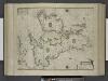
Paskaert, de Kusten van't Kanael, vertoonende alle, de Kusten van Engelandt, Schotlant, en Yerlandt, en een gedeelte van Vranckrijck.
from De zee-atlas ofte water-wereld : waer in vertoont werden alle de zee-kusten van het bekende des aerd-bodems : seer dienstigh voor alle heeren en kooplieden, als oock voor alle schippers en stuurlieden / by Pieter Goos.
Magnae Britanniae et Hiberniae Nova Descriptio [Karte] Orcades Insulae. [Nebenkarte], in: Novus atlas absolutissimus, Bd. 7, S. 29.
1 Karte aus Atlas Janssonius Offizin
Great Britain and Ireland.
1 : 4100000 Gray, Ormando Willis
Die Britischen Inseln und das Umliegende Meer
Hand-Atlas über alle Theile der Erde und über das Weltgebäude Stieler, Adolf Justus Perthes