Maps of United Kingdom

Iles Britanniques.
1 : 2500000 Lapie, M. (Pierre), 1779-1850
Die Brittischen Inseln
Schul-Atlas über alle Theile der Erde nach dem neuesten Zustande, und über das Weltgebäude Stieler, Adolf Justus Perthes
Grossbritanien und Irrland
Allgemeiner Atlas [Walch, Johannes] im Verlag bei Johannes Walch
58-59. Great Britain and Ireland. The World Atlas.
1 : 2500000 USSR (Union of Soviet Socialist Republics).
Neueste Karte von Grossbritannien und Jreland
Grosser Hand-Atlas über alle Theile der Erde in 170 Karten Meyer, J. Verlag des Bibliographischen Instituts
Die Brittischen Inseln
Schul-Atlas über alle Theile der Erde nach dem neuesten Zustande, und über das Weltgebäude Stieler, Adolf bei Justus Perthes
Die britischen Inseln
Hypsometrischer Atlas Ziegler, Jakob Melchior Topogr. Anstalt v. J. Wurster u. Comp.
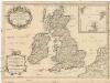
Britannia Antiqua cum Hibernia
1 : 3618000 Irsko Macpherson, A. Gleditsch
Die Britischen Inseln
E. von Sydow's Schul-Atlas in sechs und dreissig Karten Sydow, Emil von bei Justus Perthes
45-46. Gran Bretagna.
1 : 3000000 Touring club italiano
Great Britain and Ireland.
1 : 4100000 Gray, Ormando Willis
[Grossbritannien; England, Scotland und Ireland]
Geographischer Atlas über alle Theile der Erde Ziegler, Jakob Melchior Verlag von Joh. Wurster um Comp.
A new and correct chart of the sea coast of ENGLAND, SCOTLAND and IRELAND
from The sea-atlas : containing an hydrographical description of most of the sea-coasts of the known parts of the world.
British Islands.
1 : 2300000 Lizars, Daniel
Britischen Inseln.
1 : 1800000 Kiepert, Heinrich, 1818-1899
Composite: Geological, palaeontological map British Islands.
1 : 1550000 Johnston, Alexander Keith, 1804-1871
British Islands.
1 : 5500000 Fitch, George W.
Gt. Britain, Ireland.
1 : 4800000 Mitchell, Samuel Augustus
Iles Britanniques.
1 : 2500000 Andriveau-Goujon, J.
British Isles.
1 : 5000000 Adams, Daniel
Insvlæ britannicæ antiqvæ
1 Karte : Kupferdruck ; 31 x 38 cm Weigel Christoph Weigel
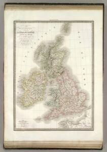
Grossbritannien, Ireland.
1 : 3800000 Flemming, Carl

Map of the British Isles
1 : 908500 Shetlandy (Skotsko) Cary, John
Grossbritannien und Ireland

Die Britischen Jnseln England, Schotland, Jreland
Stieler's Hand-Atlas Stieler, Adolf bei Justus Perthes
Magna Britannia et Hibernia
1 Karte : Kupferdruck ; 54 x 45 cm Walch; Kitchin; Dorret Johann Walch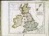
Britannicæ Insulæ
1 Karte : Kupferdruck ; 22 x 25 cm Delamarche s.n.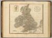
British Isles.
1 : 2550000 Cary, John, ca. 1754-1835