Maps of United Kingdom

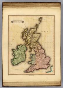
British Islands.
1 : 2300000 Lizars, Daniel
Iles Britanniques.
1 : 2500000 Lapie, M. (Pierre), 1779-1850
Pas-Caart vant Canaal 't Amsterdam. [Karte], in: De Nieuwe Groote Vermeerderde Zee-Atlas ofte Water-Werelt, S. 41.
1 Karte aus Atlas Doncker, Hendrick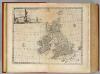
Great Britain & Ireland.
1 : 4250000 Bowen, Emanuel
Britischen Inseln.
1 : 1800000 Kiepert, Heinrich, 1818-1899
British Islands.
1 : 5500000 Fitch, George W.
Gt. Britain, Ireland.
1 : 4800000 Mitchell, Samuel Augustus
Iles Britanniques.
1 : 2500000 Andriveau-Goujon, J.
British Isles.
1 : 5000000 Adams, Daniel
Grossbritanien und Irrland
Allgemeiner Atlas [Walch, Johannes] im Verlag bei Johannes Walch
Die Brittischen Inseln
Schul-Atlas über alle Theile der Erde nach dem neuesten Zustande, und über das Weltgebäude Stieler, Adolf Justus Perthes
Grossbritannien, Ireland.
1 : 3800000 Flemming, Carl
[Grossbritannien; England, Scotland und Ireland]
Geographischer Atlas über alle Theile der Erde Ziegler, Jakob Melchior Verlag von Joh. Wurster um Comp.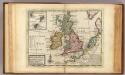
A general map of Great Britain and Ireland.
1 : 7500000 Moll, Herman, d. 1732
Great Britain and Ireland.
1 : 4100000 Gray, Ormando Willis
Die Brittischen Inseln
Schul-Atlas über alle Theile der Erde nach dem neuesten Zustande, und über das Weltgebäude Stieler, Adolf bei Justus Perthes
Die Britischen Inseln
E. von Sydow's Schul-Atlas in sechs und dreissig Karten Sydow, Emil von bei Justus Perthes
Neueste Karte von Grossbritannien und Jreland
Grosser Hand-Atlas über alle Theile der Erde in 170 Karten Meyer, J. Verlag des Bibliographischen Instituts
Die Britischen Jnseln England, Schotland, Jreland
Stieler's Hand-Atlas Stieler, Adolf bei Justus Perthes
Grossbritannien und Ireland

Map of the British Isles
1 : 908500 Shetlandy (Skotsko) Cary, John
[Grossbritannien; England, Scotland und Ireland]
Geographischer Atlas über alle Theile der Erde Ziegler, Jakob Melchior Verlag von Dietrich Reimer
Die britischen Inseln
Hypsometrischer Atlas Ziegler, Jakob Melchior Topogr. Anstalt v. J. Wurster u. Comp.
58-59. Great Britain and Ireland. The World Atlas.
1 : 2500000 USSR (Union of Soviet Socialist Republics).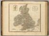
British Isles.
1 : 2550000 Cary, John, ca. 1754-1835
Anglia, Scotia et Hibernia. [Karte], in: Gerardi Mercatoris Atlas, sive, Cosmographicae meditationes de fabrica mundi et fabricati figura, S. 82.
1 Karte aus Atlas Mercator, Gerhard Montanus, Petrus
Paskaarte om achter Yrlant om te zeylen, van Hitlant tot aen Heÿssant
1 Karte : Kupferdruck ; 43 x 54 cm Doncker by Hendrick Doncker in de Nieuwbrughsteech in 't Stuurmans gereetschap
MAGNAE BRITANNIAE TABULA
1 : 3170000 Anglie Visscher, Nicolaes Jansz. per Nicolaum Visscher
British Isles - Physical Geography..
Milner, Thomas