Maps of British Isles
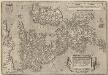
Angliae, Scotiae, Et Hiberniae, Sive Britannicar: Insularum Descriptio. [Karte], in: Theatrum orbis terrarum, S. 77.
1 Karte aus Atlas Ortelius, Abraham Vrients, Jan Baptista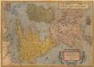
Angliae, Scotiae, Et Hiberniae, Sive Britaniicar: Insularum Descriptio. [Karte], in: Theatrum orbis terrarum, S. 24.
1 Karte aus Atlas Ortelius, Abraham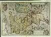
Angliae, Scotiae, et Hiberniæ, sive Britannicar: insularum descriptio
1 Karte : Kupferdruck ; 33 x 47 cm Janssonius excudebat Ioannes Ianssonius
Angliae, Scotiae, et Hiberniae, sive Britannicar: insvlarvm descriptio
1 Karte : Kupferdruck ; 33 x 48 cm Ortelius s.n.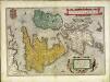
Angliae, Scotiae, et Hiberniae, sive Britannicar: insvlarvm descriptio
1 Karte : Kupferdruck ; 33 x 49 cm Ortelius s.n.
Carte des isles Britanniques et de la Manche
1 Karte : Kupferdruck ; 72 x 49 cm Brion de la Tour; Esnault; Rapilly chez Esnauts et Rapilly rue S. Jacques à la ville de Coutances
Carte générale des Iles Britanniques
1 : 2750000 par A.H. Brué Paris : chez l'auteur [etc.]

Karte des Brittischen Reichs
1 : 2700000 Irsko Brué, Adrien Hubert bey Artaria et Comp.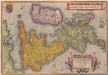
Angliae, Scotiae, Et Hiberniae, Sive Britannicarum Insularum Descriptio. [Karte] , in: Theatrum orbis terrarum, S. 30.
1 Karte aus Atlas Ortelius, Abraham
Iles Britanniques.
1 : 2950000 Montemont, A.
Great Britain and Ireland. Pergamon World Atlas.
1 : 2500000 Polish Army Topography Service
Carte de l' Angleterre
1 : 5900000 Velká Británie Delamarche, Francois Alexander
Iles Britanniques.
1 : 2500000 Picquet, C.
Geology Of The British Isles.
1 : 1025000 Wyld, James, 1812-1887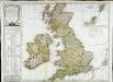
Carte des isles Britanniques qui renferment les royaumes d'Angleterre d'Ecosse [et] d'Irlande
1 Karte : Kupferdruck ; 53 x 59 cm Robert de Vaugondy; Beaublé; Fortin; Kitchin chés Fortin ingénieur du roi pour les globes et sphéres rue de la Harpe près celle du Foin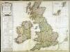
Carte des isles Britanniques qui renferment les royaumes d'Angleterre d'Ecosse [et] d'Irlande
1 Karte : Kupferdruck ; 53 x 59 cm Robert de Vaugondy; Beaublé; Delamarche; Kitchin chez le Sr. Delamarche géographe rue du Foin St. Jacques au collège de m.tre Gervais
Insularum Britannicarum Acurata Delineatio [Karte], in: Gerardi Mercatoris et I. Hondii Newer Atlas, oder, Grosses Weltbuch, Bd. 1, S. 48.
1 Karte aus Atlas Mercator, Gerhard und Hondius, Jodocus Jansson, Jan
Grossbritannien, Irland.
1 : 2500000 Andree, Richard
British Isles (outline)
1 : 4500000 Patteson, Edward
British Isles.
1 : 4500000 Patteson, Edward
Welká Britanie a Iry

Isles Britanniques.
1 : 2600000 Jouvet et Cie.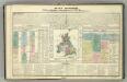
Tableau l'historie des Iles Britanniques.
1 : 8200000 Duval, Henri
Pascaart Vant Canaal Tuẞchen Engelant en Vrancryck [...] [Karte], in: Het vijfde Deel Des Grooten Atlas : Vervatende De Water-Weereld, S. 160.
1 Karte aus Atlas Jansson, Jan Jansson, Jan
Charte der vereinigten Königreiche Grosbritanien und Ireland
1 Karte : Kupferdruck ; 59 x 47 cm Weidner im Verlage des Industrie Comptoirs
Grossbritannien und Irland
1 Karte : Kupferdruck ; 29 x 25 cm Sotzmann; Jättnig s.n.
A compleat map of the British Isles or Great Britain and Ireland
1 Karte : Kupferdruck ; 59 x 46 cm Sayer publish'd by Rob.t Sayer no. 53 Fleet Street as the act directs
Carte réduite des isles Britanniques
1 Karte : Kupferdruck ; 85 x 53 cm Bellin; Haussard s.n.
![Angliae, Scotiae, Et Hiberniae, Sive Britannicar: Insularum Descriptio. [Karte], in: Theatrum orbis terrarum, S. 77.](https://images-2.georeferencer.com/images/iiif/132097932315/full/,300/0/native.jpg)

