Maps of British Isles

Pascaart Vant Canaal Tuẞchen Engelant en Vrancryck [...] [Karte], in: Het vijfde Deel Des Grooten Atlas : Vervatende De Water-Weereld, S. 160.
1 Karte aus Atlas Jansson, Jan Jansson, Jan
Pascaart Vant Canaal [...] Tabula Hydrographica Freti seu Canalis [...] quod est Inter Angliam et Galliam, nec non Hiberniam et Scotiam [...] [Karte], in: Novus atlas absolutissimus, Bd. 9, S. 213.
1 Karte aus Atlas Janssonius Offizin
Carte générale des Iles Britanniques
1 : 2750000 par A.H. Brué Paris : chez l'auteur [etc.]
Carte de l' Angleterre
1 : 5900000 Velká Británie Delamarche, Francois Alexander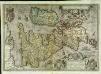
Angliae, Scotiae, et Hiberniæ, sive Britannicar: insularum descriptio
1 Karte : Kupferdruck ; 33 x 47 cm Janssonius excudebat Ioannes Ianssonius
Angliae, Scotiae, et Hiberniae, sive Britannicar: insvlarvm descriptio
1 Karte : Kupferdruck ; 33 x 48 cm Ortelius s.n.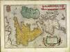
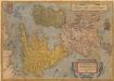
Angliae, Scotiae, et Hiberniae, sive Britannicar: insvlarvm descriptio
1 Karte : Kupferdruck ; 33 x 49 cm Ortelius s.n.
British Isles railways.
1 : 1800000 Philip, George
Pas-caart van 't Canaal
1 Karte : Kupferdruck ; 44 x 54 cm Doncker bij Hendrick Doncker boekverkooper en graadbooghmaecker inde Nieuwbrughsteegh in 't Stuurmans gereedtschap
Grossbritannien, Irland.
1 : 2500000 Andree, Richard
Carte des isles Britanniques et de la Manche
1 Karte : Kupferdruck ; 72 x 49 cm Brion de la Tour; Esnault; Rapilly chez Esnauts et Rapilly rue S. Jacques à la ville de Coutances
Angliae, Scotiae, Et Hiberniae, Sive Britaniicar: Insularum Descriptio. [Karte], in: Theatrum orbis terrarum, S. 24.
1 Karte aus Atlas Ortelius, Abraham
Iles Britanniques.
1 : 2500000 Brue, Adrien Hubert, 1786-1832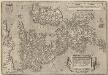
Angliae, Scotiae, Et Hiberniae, Sive Britannicar: Insularum Descriptio. [Karte], in: Theatrum orbis terrarum, S. 77.
1 Karte aus Atlas Ortelius, Abraham Vrients, Jan Baptista
Isles Britanniques.
1 : 2600000 Jouvet et Cie.
Iles Britanniques.
1 : 2950000 Montemont, A.
Geology Of The British Isles.
1 : 1025000 Wyld, James, 1812-1887
Karte des Brittischen Reichs
1 : 2700000 Irsko Brué, Adrien Hubert bey Artaria et Comp.
Iles Britanniques.
1 : 2500000 Picquet, C.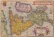
Angliae, Scotiae, Et Hiberniae, Sive Britannicarum Insularum Descriptio. [Karte] , in: Theatrum orbis terrarum, S. 30.
1 Karte aus Atlas Ortelius, Abraham
Grossbritanien.
1 : 3900000 Haller von Hallerstein, Friedrich; Reichard, C. G.
Britische Inseln
Volksschul-Atlas über alle Teile der Erde Lange, Henry Druck und Verlag von Georg Westermann
Pas-Caart vant Canaal 't Amsterdam. [Karte], in: De Nieuwe Groote Vermeerderde Zee-Atlas ofte Water-Werelt, S. 41.
1 Karte aus Atlas Doncker, Hendrick
Great Britain and Ireland. Pergamon World Atlas.
1 : 2500000 Polish Army Topography Service
The British Isles. (with) inset map of the Shetland Islands.
1 : 3801600 Tallis, J. & F.
Great Britain, Ireland.
1 : 5500000 Huntington, Nathaniel G. (Nathaniel Gilbert), 1785-1848
British Isles.
1 : 6200000 Worcester, Joseph E.
Tabula novissima accuratissima regnorum Angliæ, Scotiæ Hiberniæ
1 Karte : Kupferdruck ; 56 x 48 cm Lotter Tobias Konrad Lotter
Tabula novissima accuratissima regnorum Angliæ, Scotiæ Hiberniæ
1 Karte : Kupferdruck ; 57 x 48 cm Seutter Matthäus Seutter
Carte du gouvernement militaire d'Angleterre
1 Karte : Kupferdruck ; 16 x 15 cm, Bildgrösse 35 x 46 cm Châtelain s.n.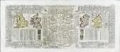
Nouvelle carte pour introduire a la geographie et a la genealogie des rois d'Angleterre et d'Ecosse
4 Karten auf 2 Blättern : Kupferdruck ; Bildgrösse 38 x 92 cm Châtelain s.n.
![Pascaart Vant Canaal Tuẞchen Engelant en Vrancryck [...] [Karte], in: Het vijfde Deel Des Grooten Atlas : Vervatende De Water-Weereld, S. 160.](https://images-2.georeferencer.com/images/iiif/206478324999/full/,300/0/native.jpg)

