Maps of British Isles

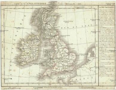
Carte de l' Angleterre
1 : 5900000 Velká Británie Delamarche, Francois Alexander
Carte générale des Iles Britanniques
1 : 2750000 par A.H. Brué Paris : chez l'auteur [etc.]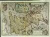
Angliae, Scotiae, et Hiberniæ, sive Britannicar: insularum descriptio
1 Karte : Kupferdruck ; 33 x 47 cm Janssonius excudebat Ioannes Ianssonius
Angliae, Scotiae, et Hiberniae, sive Britannicar: insvlarvm descriptio
1 Karte : Kupferdruck ; 33 x 48 cm Ortelius s.n.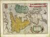
Angliae, Scotiae, et Hiberniae, sive Britannicar: insvlarvm descriptio
1 Karte : Kupferdruck ; 33 x 49 cm Ortelius s.n.
Karte des Brittischen Reichs
1 : 2700000 Irsko Brué, Adrien Hubert bey Artaria et Comp.

Pas-caart van 't Canaal
1 Karte : Kupferdruck ; 44 x 54 cm Doncker bij Hendrick Doncker boekverkooper en graadbooghmaecker inde Nieuwbrughsteegh in 't Stuurmans gereedtschap
Britische Inseln
Volksschul-Atlas über alle Teile der Erde Lange, Henry Druck und Verlag von Georg Westermann
British Isles.
1 : 2500000 Andree, Richard; Times (London, England)
Pascaart Vant Canaal Tuẞchen Engelant en Vrancryck [...] [Karte], in: Het vijfde Deel Des Grooten Atlas : Vervatende De Water-Weereld, S. 160.
1 Karte aus Atlas Jansson, Jan Jansson, Jan
Grossbritanien und Irrland
Allgemeiner Atlas [Walch, Johannes] im Verlag bei Johannes Walch
Die Brittischen Inseln
Schul-Atlas über alle Theile der Erde nach dem neuesten Zustande, und über das Weltgebäude Stieler, Adolf bei Justus Perthes
Isles Britanniques.
1 : 2600000 Jouvet et Cie.
Carte des isles Britanniques et de la Manche
1 Karte : Kupferdruck ; 72 x 49 cm Brion de la Tour; Esnault; Rapilly chez Esnauts et Rapilly rue S. Jacques à la ville de Coutances
Welká Britanie a Iry

Geology Of The British Isles.
1 : 1025000 Wyld, James, 1812-1887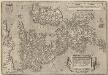
Angliae, Scotiae, Et Hiberniae, Sive Britannicar: Insularum Descriptio. [Karte], in: Theatrum orbis terrarum, S. 77.
1 Karte aus Atlas Ortelius, Abraham Vrients, Jan Baptista
Die Brittischen Inseln
Schul-Atlas über alle Theile der Erde nach dem neuesten Zustande, und über das Weltgebäude Stieler, Adolf Justus Perthes
Die britischen Inseln
Hypsometrischer Atlas Ziegler, Jakob Melchior Topogr. Anstalt v. J. Wurster u. Comp.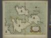
A new and correct chart of the sea coast of ENGLAND, SCOTLAND and IRELAND
from The sea-atlas : containing an hydrographical description of most of the sea-coasts of the known parts of the world.
Die Britischen Inseln
E. von Sydow's Schul-Atlas in sechs und dreissig Karten Sydow, Emil von bei Justus Perthes
Die Britischen Jnseln England, Schotland, Jreland
Stieler's Hand-Atlas Stieler, Adolf bei Justus Perthes
INSVLÆ | ALBION | et | HIBERNIA | cum minoribus adjacentibus
[Amsterdam : Joan Blaeu]
Neueste Karte von Grossbritannien und Jreland
Grosser Hand-Atlas über alle Theile der Erde in 170 Karten Meyer, J. Verlag des Bibliographischen Instituts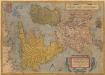
Angliae, Scotiae, Et Hiberniae, Sive Britaniicar: Insularum Descriptio. [Karte], in: Theatrum orbis terrarum, S. 24.
1 Karte aus Atlas Ortelius, Abraham
[Grossbritannien; England, Scotland und Ireland]
Geographischer Atlas über alle Theile der Erde Ziegler, Jakob Melchior Verlag von Joh. Wurster um Comp.
Map of the British Isles
1 : 908500 Shetlandy (Skotsko) Cary, John
[Grossbritannien; England, Scotland und Ireland]
Geographischer Atlas über alle Theile der Erde Ziegler, Jakob Melchior Verlag von Dietrich Reimer