Maps of British Isles

Großbritannien und Irland
1 : 1000000 Irsko Velhagen & Klasing
Die Britischen Inseln nach ihrer kirchlichen Eintheilung bis zur Reformation.
1 : 3000000 Spruner von Merz, Karl
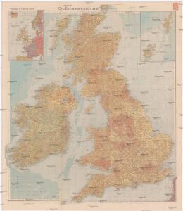
The British Isles
1 : 3000000 Debenham, Frank
Regno Unito della Gran Brettagna e dell'Irlanda.
1 : 2500000 Picquet, C.
British Isles.
1 : 2500000 Andree, Richard; Times (London, England)
Die Britischen Inseln seit 1485.
1 : 3000000 Spruner von Merz, Karl
Britische Inseln
Volksschul-Atlas über alle Teile der Erde Lange, Henry Druck und Verlag von Georg Westermann
British Islands.
1 : 4000000 Schonberg & Co.
Philips Railway map of the British Isles

Grossbritanien.
1 : 3900000 Haller von Hallerstein, Friedrich; Reichard, C. G.
[Ethnographic Map of Great Britain and Ireland]
The physical atlas Johnston, Alexander Keith William Blackwood & Sons
Welká Britanie a Iry

Britania et Hibernia
1 : 3000000 Irsko, ostrov Spruner, Karl von Justus Perthes
Karte des Brittischen Reichs
1 : 2700000 Irsko Brué, Adrien Hubert bey Artaria et Comp.

[Grossbritannien; England, Scotland und Ireland]
Geographischer Atlas über alle Theile der Erde Ziegler, Jakob Melchior Verlag von Dietrich Reimer
Welká Britanie a Iry
1 : 3400000 Irsko Merklas, Václav W. Merklas
Die Britischen Inseln 1066 bis 1485.
1 : 3100000 Spruner von Merz, Karl
Soubor němých map pro gymnasia a odborné školy

Grossbritannien, Ireland.
1 : 3800000 Flemming, Carl
Pascaart Vant Canaal [...] Tabula Hydrographica Freti seu Canalis [...] quod est Inter Angliam et Galliam, nec non Hiberniam et Scotiam [...] [Karte], in: Novus atlas absolutissimus, Bd. 9, S. 213.
1 Karte aus Atlas Janssonius Offizin
Britischen Inseln.
1 : 1800000 Kiepert, Heinrich, 1818-1899
British Islands.
1 : 5500000 Fitch, George W.
Gt. Britain, Ireland.
1 : 4800000 Mitchell, Samuel Augustus
Iles Britanniques.
1 : 2500000 Andriveau-Goujon, J.
British Isles.
1 : 5000000 Adams, Daniel
British Isles.
1 : 2661120 Letts, Son & Co.
Railway Map of the British Isles.
1 : 2217600 Fullarton, A. & Co.
The British Isles.
1 : 2700000 Society for the Diffusion of Useful Knowledge (Great Britain)
British Islands.
1 : 3484800 Burr, David H., 1803-1875
British Isles, Asia.
Adams, Daniel