Maps of British Isles

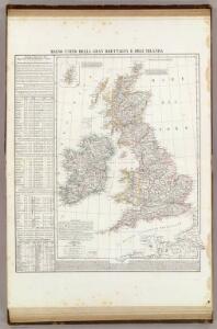
Regno Unito della Gran Brettagna e dell'Irlanda.
1 : 2500000 Picquet, C.
British Isles.
1 : 2500000 Andree, Richard; Times (London, England)
Map of the British Isles.
1 : 3500000 Warner & Beers
British Isles.
1 : 4100000 Cornell, S. S. (Sarah S.)
Iles Britanniques, chemins de fer, canaux.
1 : 2700000 Garnier, F. A., 1803-1863
Iles Britanniques.
1 : 2900000 Garnier, F. A., 1803-1863
British Isles.
1 : 9300000 Fenner, Rest.
Gt. Britain, Ireland.
1 : 1800000 Robert Laurie & James Whittle
A compleat map of the British Isles.
1 : 2200000 Kitchin, Thomas
Pas-caart van 't Canaal
1 Karte : Kupferdruck ; 44 x 54 cm Doncker bij Hendrick Doncker boekverkooper en graadbooghmaecker inde Nieuwbrughsteegh in 't Stuurmans gereedtschap
[Grossbritannien; England, Scotland und Ireland]
Geographischer Atlas über alle Theile der Erde Ziegler, Jakob Melchior Verlag von Dietrich Reimer
Britischen Inseln.
1 : 1800000 Kiepert, Heinrich, 1818-1899
British Islands.
1 : 5500000 Fitch, George W.
Gt. Britain, Ireland.
1 : 4800000 Mitchell, Samuel Augustus
Iles Britanniques.
1 : 2500000 Andriveau-Goujon, J.
British Isles.
1 : 5000000 Adams, Daniel
The British Isles. (with) inset map of the Shetland Islands.
1 : 3801600 Tallis, J. & F.
Great Britain, Ireland.
1 : 5500000 Huntington, Nathaniel G. (Nathaniel Gilbert), 1785-1848
British Isles.
1 : 6200000 Worcester, Joseph E.
Tabula novissima accuratissima regnorum Angliæ, Scotiæ Hiberniæ
1 Karte : Kupferdruck ; 56 x 48 cm Lotter Tobias Konrad Lotter
Tabula novissima accuratissima regnorum Angliæ, Scotiæ Hiberniæ
1 Karte : Kupferdruck ; 57 x 48 cm Seutter Matthäus Seutter
Carte du gouvernement militaire d'Angleterre
1 Karte : Kupferdruck ; 16 x 15 cm, Bildgrösse 35 x 46 cm Châtelain s.n.
Nouvelle carte pour introduire a la geographie et a la genealogie des rois d'Angleterre et d'Ecosse
4 Karten auf 2 Blättern : Kupferdruck ; Bildgrösse 38 x 92 cm Châtelain s.n.
Insvlarvm britannicarvm acurata delineatio
1 Karte : Kupferdruck ; 37 x 49 cm Ortelius; Janssonius; Keere apud Ioannem Ianssonium
[Grossbritannien; England, Scotland und Ireland]
Geographischer Atlas über alle Theile der Erde Ziegler, Jakob Melchior Verlag von Joh. Wurster um Comp.
United Kingdom of England, Scotland and Ireland.
1 : 4500000 Worcester, J. E.
Die Britischen Inseln
E. von Sydow's Schul-Atlas in sechs und dreissig Karten Sydow, Emil von bei Justus Perthes
Die Britischen Jnseln England, Schotland, Jreland
Stieler's Hand-Atlas Stieler, Adolf bei Justus Perthes
Grossbritannien, Ireland.
1 : 3800000 Flemming, Carl