Maps of British Isles

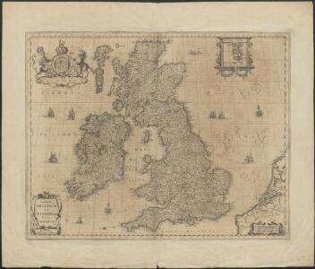
Magnae Britanniae et Hiberniae nova descriptio
1 : 2500000 Amstelodami : apud Joannem Janssonium
Magnae Britanniae et Hiberniae Tabula [Karte] Orcades Insulae [Nebenkarte], in: Novus Atlas, das ist, Weltbeschreibung, Bd. 3, S. 358.
1 Karte aus Atlas Blaeu, Joan Blaeu, Willem Janszoon
Magnae Britanniae et Hiberniae Tabula [Karte] [Orcades Insulae] [Nebenkarte], in: Theatrum orbis terrarum, sive, Atlas novus, Bd. 4, S. 16.
1 Karte aus Atlas Blaeu, Joan Blaeu, Willem Janszoon
Nieuwe en perfeckte caerte van Engelandt, Schotlandt en Yerlandt
1 : 2470000 [Amsterdam] : nieuwelijck uyt gegeven bij Hugo Allardt, in de Calverstraet inde Werrelt Caert
Magnae Britanniae et Hiberniae Tabula [Karte] [Orcades Insulae] [Nebenkarte], in: Theatrum orbis terrarum, sive, Atlas novus, Bd. 4, S. 16.
1 Karte aus Atlas Blaeu, Joan Blaeu, Willem Janszoon
Magnae Britanniae et Hiberniae Tabula [Karte] Orcades Insulae [Nebenkarte], in: Le théâtre du monde, ou, Nouvel atlas contenant les chartes et descriptions de tous les païs de la terre, Bd. 4, S. 18.
1 Karte aus Atlas Blaeu, Willem Janszoon und Blaeu, Joan Blaeu, Willem Janszoon
Magnae Britanniae et Hiberniae Nova Descriptio [Karte] Orcades Insulae. [Nebenkarte], in: Novus atlas absolutissimus, Bd. 7, S. 29.
1 Karte aus Atlas Janssonius Offizin
Magnae Britanniae et Hiberniae Tabula. [Karte] Orcades Insulae [Nebenkarte], in: Gerardi Mercatoris et I. Hondii Newer Atlas, oder, Grosses Weltbuch, Bd. 1, S. 51.
1 Karte aus Atlas Mercator, Gerhard und Hondius, Jodocus Jansson, Jan
Nieuwe kaart van de eilanden van Groot Brittannien : behelzende de koningryken Engeland, Schotland en Ierland / volgens de laatste waarnemingen in het ligt gebragt ; C. Sepp del. et sculps. 1743
1 : 3500000 Annotatie: Oorspr. verschenen in: Nieuwe hand-atlas ... - Amsterdam : Isaak Tirion, 1744 Sepp, C. Te Amsterdam : by Isaak Tirion
Nova totius Angliae, Scotiae, et Hiberniae tab: / auctore Frederick de Wit
1 : 2250000 Annotatie: Origineel is Blad 22 in atlas factice; Annotatie geografische gegevens: Met 3 schaalstokken Frederick de Wit 1630-1706 'T Amsterdam : by Frederick de Wit
Britannia prout divisa fuit temporibus Anglo-Saxonum, praesertim durante illorum Heptarchia [Karte], in: Theatrum orbis terrarum, sive, Atlas novus, Bd. 4, S. 87.
1 Karte aus Atlas Blaeu, Joan Blaeu, Willem Janszoon
[85][85] Nova totius Angliae, Scotiae, et Hiberniae tab:, uit: Atlas sive Descriptio terrarum orbis
Annotatie: Gedigitaliseerde versie. Amsterdam. Heiloo : Picturae (vervaardiger), 2015. tiff-bestand. Gedigitaliseerd: 07-01-2015; Origineel: Universiteitsbibliotheek Vrije Universiteit (XL.05127.-) ; Netherlands; Titelpagina ontbreekt Wit, Frederik de Amsterdam : Frederick de Wit
Britannia prout divisa fuit temporibus Anglo-Saxonum, praesertim durante illorum Heptarchia [Karte], in: Novus atlas absolutissimus, Bd. 7, S. 88.
1 Karte aus Atlas Janssonius Offizin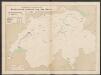
Britannia prout divisa fuit temporibus Anglo-Saxonum praesertim durante illorum Heptarchia. [Karte], in: Le théâtre du monde, ou, Nouvel atlas contenant les chartes et descriptions de tous les païs de la terre, Bd. 4, S. 81.
1 Karte aus Atlas Blaeu, Willem Janszoon und Blaeu, Joan Blaeu, Willem Janszoon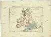
Allgemeine Postkarte von Gross Britanien und Ireland zur Uebersicht
Irsko Stenger, Johann im von Reillyschen Landkarten und Kunstwerke Verschleiss Komptoir
Britannia prout divisa fuit temporibus Anglo-Saxonum, praesertim durante illorum Heptarchia [Karte], in: Theatrum orbis terrarum, sive, Atlas novus, Bd. 4, S. 87.
1 Karte aus Atlas Blaeu, Joan Blaeu, Willem Janszoon
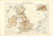
Nieuwe kaart der Britsche Eilanden Engeland, Schotland en Irland.
1 : 6000000 [S.l.] : [s.n.]
Magnae Britanniae et Hiberniae Tabula
1 : 2300000
MAGNÆ | BRITANNIÆ | et | HIBERNIÆ | TABVLA.
AMSTELODAMI, | Guiljelmus Blaeuw ecudit
58-59. Great Britain and Ireland. The World Atlas.
1 : 2500000 USSR (Union of Soviet Socialist Republics).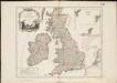
Les Isles Britanniques, qui comprennent les Royaumes d'Angleterre, d'Ecosse et d'Irlande
1 : 2000000
La grande Bretagne ou les Royaumes d'Angleterre et d'Ecosse comme aussi le Royaume d'Irlande
1 : 2300000 Anglie Lotter, Matthäus Albrecht T. C. Lotter
Les Isles Britanniques

La Grande Bretagne ou les royaumes d'Angleterre et d'Ecosse comme aussi le royaume d'Irlande
1 : 2300000 Anglie Lotter, Tobias Conrad Lotter, Matthäus Albrecht par Tobie Conrad Lotter
MAGNAE BRITANNIAE TABULA
1 : 3170000 Anglie Visscher, Nicolaes Jansz. per Nicolaum Visscher
LES ISLES BRITANNIQUES
1 : 2500000 Anglie Jaillot, Alexis-Hubert H. Iaillot

Atlas für Industrie- und Handelsgeographie: Für commercielle und technische Lehranstalten, für Kaufleute und Industrielle

Regnorum Magnae Britanniae et Hiberniae mappa geographica
1 : 2500000 Irsko Mayer, Tobias Homan[n]ianis Heredibus