Maps of British Isles

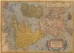
Britannicarum insularum typus / ex conatibus geographicis Abrah. Ortelius
1 : 2500000 Annotatie: Oorspr. verschenen in: Theatrum Orbis Terrarum opus nunc denuo ... - [Antwerpen : Abraham Ortelius]; Origineel is Blad 24 in atlas factice; Annotatie geografische gegevens: West boven Ortelius, Abraham [Antwerpen : Arbraham Ortelius]
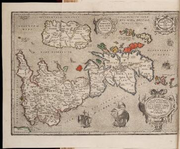
Insularum Britannicarum acurata delineatio ex geographicis conatibus Abrahami Ortelii
1 : 2500000 Petrus Kaerius caelavit Amstelodami : apud Joannem Janssonium
Her most excellent majesty queen Victoria this Hydrolographical map of the British Isles
1 : 1600000 Velká Británie Petermann, August Symons, G. J. Edward Stanford
Welká Britanie a Iry
Britannicarum Insularum Typus. [Karte], in: Theatrum orbis terrarum, S. 365.
1 Karte aus Atlas Ortelius, Abraham
Welká Britanie a Iry
1 : 3400000 Irsko Merklas, Václav W. Merklas

Grande Bretagne, Irlande 1400 a 1603.
1 : 4500000 Houze, Antoine Philippe
Angleterre, Ecosse & Irlande en 900.
1 : 4500000 Houze, Antoine Philippe
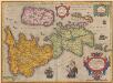
Insularum Britannicarum Acurata Delineatio ex Geographicis Conatibus Abrahami Ortelii [Karte], in: Novus atlas absolutissimus, Bd. 7, S. 14.
1 Karte aus Atlas Janssonius Offizin
Grossbritannien und Ireland
1 : 2200000 Irsko Weiland, Karl Ferdinand Maedel, Carl Jos. Geograph. Institut
Insularum Britannicarum Acurata Delineatio [Karte], in: Gerardi Mercatoris et I. Hondii Newer Atlas, oder, Grosses Weltbuch, Bd. 1, S. 48.
1 Karte aus Atlas Mercator, Gerhard und Hondius, Jodocus Jansson, Jan
British Isles (outline)
1 : 4500000 Patteson, Edward
British Isles.
1 : 4500000 Patteson, Edward
British Isles.
1 : 3651000 Fisher, Richard Swainson
Die Britischen Inseln oder die Vereinigten Königreiche
1 : 1850000 Normanské ostrovy Kiepert, Heinrich Gräf, C. Geographisches Institut
Insulae Britannicae
1 : 3760000 Velká Británie Bonne, Rigobert André
British Islands.
1 : 4700000 Grigg, John
Britannia et Hibernia.
1 : 3000000 Strabo
Geological map, British Isles.
1 : 1600000 Stanford, Edward
Composite: Carte des Iles Britanniques.
1 : 2600000 Vivien de St Martin, L.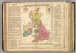
British Empire.
1 : 3200000 Lavoisne, M.
Rainfall, temperature, British Isles.
1 : 6950000 Stanford, Edward
British Islands.
1 : 2300000 Morse, Jedidiah; Morse, Sidney E. (Sidney Edwards), 1794-1871
Tabula novissima accuratissima regnorum Angliae, Scotiae Hiberniae
1 : 1850000 Irsko Seutter, Matthäus Mattheo Seutter
Stereographical map, British Isles.
1 : 1600000 Stanford, Edward
British Isles.
1 : 2250000 Hall, S. (Sidney)
Magna Britannia et Hibernia
1 : 2400000 Irsko Walch, Johann Dorret, J. J. Walch
Magna Britannia et Hibernia
1 : 2400000 Irsko Walch, Johann Dorret, J. J. Walch